Property Record
46550 Se North Bend Way, North Bend, WA 98045
NEARBY LISTINGS FOR SALE OR LEASE
-
-
View all North Bend listings for sale on LoopNet.com
Property Detail
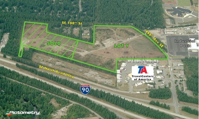
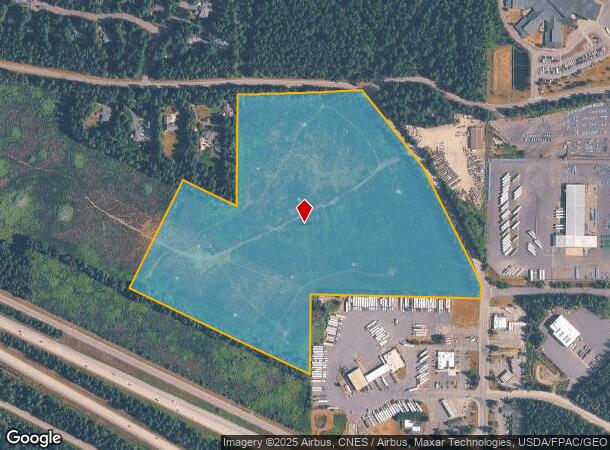
46550 Se North Bend Way
Seattle-Tacoma-Bellevue, WA
Bla L08l0051
132308-9020
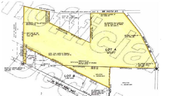
LOT Y OF KC BLA L08L0051 REC #20081014900009 SD LLA LOCATED IN S 1/2 OF SE 1/4 OF 13-23-08 & NW 1/4 OF NE 1/4 OF 24-23-08
Industrialacreage
King
D
Washington
53033C1076J
y
2025
35.74 AC
2024
E King County
032704
Seattle/Puget Sound
DEMOGRAPHICS near 46550 Se North Bend Way
1 Mile
3 Mile
5 Mile
2024 Total Population
2,104
10,399
15,945
2029 Population
2,157
10,520
16,065
Pop Growth 2024-2029
+ 2.52%
+ 1.16%
+ 0.75%
Average Age
41
41
41
2024 Total Households
747
3,752
5,847
HH Growth 2024-2029
+ 2.28%
+ 0.91%
+ 0.53%
Median Household Inc
$162,594
$150,682
$139,220
Avg Household Size
2.80
2.70
2.70
2024 Avg HH Vehicles
2.00
2.00
2.00
Median Home Value
$740,740
$754,964
$763,770
Median Year Built
1991
1987
1986
Nearby Places
Map Layers
Map Styles
 Street
 Aerial
- Restaurants
- Banks
- Shops
- Fitness
- Groceries
PUBLIC TRANSPORTATION
AIRPORT
Seattle-Tacoma International
DRIVE
WALK
Distance
Seattle-Tacoma International
52 min
39.7 mi
Freight Ports
Port of Seattle
DRIVE
WALK
Distance
Port of Seattle
47 min
36.3 mi
SALE & LEASE HISTORY
LISTING DATE
SALE/LEASE

Sep 24, 2016
For Sale
Nearby Properties
Address
Land Use
TOTAL SIZE
Lot Size
Zoning
Address
Land Use
TOTAL SIZE
Lot Size
Zoning
157,785 SF
8.21 AC
EP
Address
Land Use
TOTAL SIZE
Lot Size
Zoning
970 SF
5.40 AC
NMU
Address
Land Use
TOTAL SIZE
Lot Size
Zoning
87,600 SF
40.21 AC
RA5
Address
Land Use
TOTAL SIZE
Lot Size
Zoning
1,060 SF
10.86 AC
NMU
Address
Land Use
TOTAL SIZE
Lot Size
Zoning
2,050 SF
2.10 AC
NMU
Address
Land Use
TOTAL SIZE
Lot Size
Zoning
1,488 SF
30.76 AC
F
Address
Land Use
TOTAL SIZE
Lot Size
Zoning
1,760 SF
4.82 AC
POSPF
Address
Land Use
TOTAL SIZE
Lot Size
Zoning
12,100 SF
38.68 AC
RA10
Address
Land Use
TOTAL SIZE
Lot Size
Zoning
42,723 SF
15.56 AC
POSPF
Address
Land Use
TOTAL SIZE
Lot Size
Zoning
42,719 SF
6.70 AC
EP
Address
Land Use
TOTAL SIZE
Lot Size
Zoning
7,603 SF
15.50 AC
IC
Address
Land Use
TOTAL SIZE
Lot Size
Zoning
40,600 SF
3.21 AC
EP
Address
Land Use
TOTAL SIZE
Lot Size
Zoning
5.24 AC
IC
Address
Land Use
TOTAL SIZE
Lot Size
Zoning
33,595 SF
3.44 AC
EP
Address
Land Use
TOTAL SIZE
Lot Size
Zoning
18,672 SF
4.22 AC
NMU
Address
Land Use
TOTAL SIZE
Lot Size
Zoning
13,166 SF
2.36 AC
POSPF
Address
Land Use
TOTAL SIZE
Lot Size
Zoning
16.97 AC
EP
Address
Land Use
TOTAL SIZE
Lot Size
Zoning
18,488 SF
0.93 AC
IC
Address
Land Use
TOTAL SIZE
Lot Size
Zoning
19,000 SF
5.04 AC
MDR
Address
Land Use
TOTAL SIZE
Lot Size
Zoning
9.30 AC
NMU
Address
Land Use
TOTAL SIZE
Lot Size
Zoning
5.01 AC
HDR
Address
Land Use
TOTAL SIZE
Lot Size
Zoning
4,650 SF
2.42 AC
EP
Address
Land Use
TOTAL SIZE
Lot Size
Zoning
17,600 SF
1 AC
NMU
Address
Land Use
TOTAL SIZE
Lot Size
Zoning
10.98 AC
EP
Address
Land Use
TOTAL SIZE
Lot Size
Zoning
6,944 SF
6.69 AC
EP
Address
Land Use
TOTAL SIZE
Lot Size
Zoning
12,992 SF
1.33 AC
NMU
Address
Land Use
TOTAL SIZE
Lot Size
Zoning
1,800 SF
4.53 AC
EP
The World's #1 Commercial Real Estate Marketplace
Connect with us
© 2026 CoStar Group
The information above has been obtained from sources believed reliable. While we do not doubt its accuracy we have not verified it and make no guarantee, warranty or representation about it. It is your responsibility to independently confirm its accuracy and completeness. Any projections, opinions, assumptions, or estimates used are for example only and do not represent the current or future performance of the property. The value of this transaction to you depends on tax and other factors which should be evaluated by your tax, financial, and legal advisors. You and your advisors should conduct a careful, independent investigation of the property to determine to your satisfaction the suitability of the property for your needs.