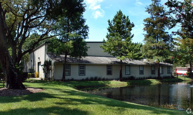
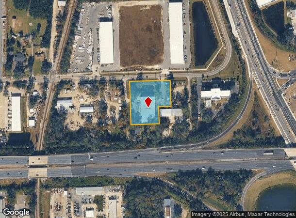
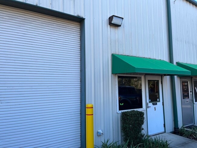
Property Record
4656 Collins Rd, Jacksonville, FL 32244

NEARBY LISTINGS FOR SALE OR LEASE
Property Detail
4656 Collins Rd
Jacksonville, FL
Island View
100221-0010
6-10 40-3S-26E 1.750 ISLAND VIEW PT LOTS 1,11 RECD O/R 11399-173, LOT 12 BLK 3
Warehouse
Duval
X
Florida
12031C0529J
1,11
2025
1.72 AC
2026
Orange Park/Clay Cnty
013302
Jacksonville (Florida)
20,295 SF
DEMOGRAPHICS near 4656 Collins Rd
1 Mile
3 Mile
5 Mile
2024 Total Population
9,008
49,532
117,885
2029 Population
9,833
53,189
125,557
Pop Growth 2024-2029
+ 9.16%
+ 7.38%
+ 6.51%
Average Age
39
39
40
2024 Total Households
3,623
19,494
45,691
HH Growth 2024-2029
+ 9.52%
+ 7.53%
+ 6.62%
Median Household Inc
$48,664
$56,578
$65,137
Avg Household Size
2.20
2.40
2.50
2024 Avg HH Vehicles
2.00
2.00
2.00
Median Home Value
$138,497
$193,715
$234,421
Median Year Built
1990
1987
1985
Nearby Places
Map Layers
Map Styles
 Street
 Aerial
- Restaurants
- Banks
- Shops
- Fitness
- Groceries
PUBLIC TRANSPORTATION
AIRPORT
Jacksonville International
DRIVE
WALK
Distance
Jacksonville International
31 min
28.3 mi
Freight Ports
Jacksonville Port
DRIVE
WALK
Distance
Jacksonville Port
1 min
12.4 mi
SALE & LEASE HISTORY
LISTING DATE
SALE/LEASE

Sep 25, 2025
For Lease
Jun 21, 2021
For Lease
Jan 24, 2023
For Lease
Jan 17, 2017
For Lease
Feb 12, 2024
For Lease
Aug 08, 2019
For Lease
Nearby Properties
Address
Land Use
TOTAL SIZE
Lot Size
Zoning
Address
Land Use
TOTAL SIZE
Lot Size
Zoning
721,413 SF
46.72 AC
REBS
Address
Land Use
TOTAL SIZE
Lot Size
Zoning
446,722 SF
13.26 AC
PUD
Address
Land Use
TOTAL SIZE
Lot Size
Zoning
336,253 SF
30.19 AC
PUD
Address
Land Use
TOTAL SIZE
Lot Size
Zoning
270,088 SF
18.50 AC
PUD
Address
Land Use
TOTAL SIZE
Lot Size
Zoning
411,303 SF
26.71 AC
RMD-C
Address
Land Use
TOTAL SIZE
Lot Size
Zoning
250,798 SF
16.84 AC
PUD
Address
Land Use
TOTAL SIZE
Lot Size
Zoning
246,982 SF
24.84 AC
PUD
Address
Land Use
TOTAL SIZE
Lot Size
Zoning
238,713 SF
53.48 AC
BB
Address
Land Use
TOTAL SIZE
Lot Size
Zoning
227,234 SF
19.99 AC
RD-4
Address
Land Use
TOTAL SIZE
Lot Size
Zoning
281,440 SF
17.01 AC
Address
Land Use
TOTAL SIZE
Lot Size
Zoning
402,240 SF
20.66 AC
PUD
Address
Land Use
TOTAL SIZE
Lot Size
Zoning
355,124 SF
18.80 AC
PUD
Address
Land Use
TOTAL SIZE
Lot Size
Zoning
278,173 SF
27.85 AC
Address
Land Use
TOTAL SIZE
Lot Size
Zoning
296,311 SF
20.07 AC
Address
Land Use
TOTAL SIZE
Lot Size
Zoning
290,919 SF
18.75 AC
PUD
Address
Land Use
TOTAL SIZE
Lot Size
Zoning
380,002 SF
60.91 AC
RG-1
Address
Land Use
TOTAL SIZE
Lot Size
Zoning
277,912 SF
19.65 AC
Address
Land Use
TOTAL SIZE
Lot Size
Zoning
348,247 SF
31.85 AC
PUD
Address
Land Use
TOTAL SIZE
Lot Size
Zoning
244,004 SF
24.97 AC
PUD
Address
Land Use
TOTAL SIZE
Lot Size
Zoning
281,174 SF
25.34 AC
PUD
Address
Land Use
TOTAL SIZE
Lot Size
Zoning
92,193 SF
20.65 AC
PUD
Address
Land Use
TOTAL SIZE
Lot Size
Zoning
33,237 SF
33.08 AC
Address
Land Use
TOTAL SIZE
Lot Size
Zoning
188,578 SF
13.44 AC
RMD-D
Address
Land Use
TOTAL SIZE
Lot Size
Zoning
216,883 SF
18.80 AC
CCG-1
Address
Land Use
TOTAL SIZE
Lot Size
Zoning
228,290 SF
12.65 AC
RMD-D
Address
Land Use
TOTAL SIZE
Lot Size
Zoning
168,475 SF
9.38 AC
RD-4
Address
Land Use
TOTAL SIZE
Lot Size
Zoning
222,038 SF
18.22 AC
RMD-C
Address
Land Use
TOTAL SIZE
Lot Size
Zoning
96,314 SF
21.05 AC
CCG-1
Address
Land Use
TOTAL SIZE
Lot Size
Zoning
159,684 SF
6.48 AC
Address
Land Use
TOTAL SIZE
Lot Size
Zoning
130,452 SF
6.50 AC
The World's #1 Commercial Real Estate Marketplace
Connect with us
© 2026 CoStar Group
The information above has been obtained from sources believed reliable. While we do not doubt its accuracy we have not verified it and make no guarantee, warranty or representation about it. It is your responsibility to independently confirm its accuracy and completeness. Any projections, opinions, assumptions, or estimates used are for example only and do not represent the current or future performance of the property. The value of this transaction to you depends on tax and other factors which should be evaluated by your tax, financial, and legal advisors. You and your advisors should conduct a careful, independent investigation of the property to determine to your satisfaction the suitability of the property for your needs.