Property Record
467 Main St, Wilbraham, MA 01095
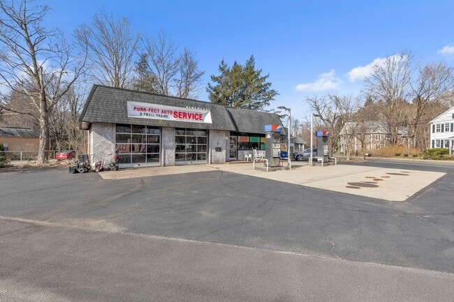


This Property Is For Sale
Property Detail
467 Main St
WILB-007000-000330-002767
Hampden
Gasolinefuelbulkstorage
Massachusetts
NS
2767
B and X Area of moderate flood hazard, usually the area between the limits of the 100-year and 500-year floods.
0.21 AC
2025
Hampden County
2025
Hartford
813602
Springfield, MA
1,296 SF
NEARBY LISTINGS FOR SALE OR LEASE
-
-
View all Wilbraham listings for sale on LoopNet.com
DEMOGRAPHICS near 467 Main St
1 mile
3 mile
5 mile
2025 Total Population
1,766
18,062
77,205
2030 Population
1,772
18,114
77,403
Pop Growth 2025-2030
+ 0.34%
+ 0.29%
+ 0.26%
Average Age
45
44
42
2025 Total Households
662
6,996
29,931
HH Growth 2025-2030
+ 0.30%
+ 0.29%
+ 0.21%
Median Household Inc
$127,113
$111,109
$82,108
Avg Household Size
2.60
2.50
2.50
2025 Avg HH Vehicles
2.00
2.00
2.00
Median Home Value
$401,034
$370,393
$311,791
Median Year Built
1957
1963
1961
Nearby Places
Map Layers
Map Styles
 Street
 Aerial
Layers
 Traffic
 Biking
Places
Listings with unknown addresses are not visible on the map
- Restaurants
- Banks
- Shops
- Fitness
- Groceries
PUBLIC TRANSPORTATION
COMMUTER RAIL
Drive
Walk
Distance
16 min
9.3 mi
AIRPORT
Bradley International
Drive
Walk
Distance
Bradley International
46 min
24.4 mi
Worcester Regional
Drive
Walk
Distance
Worcester Regional
69 min
44.3 mi
Nearby Properties
Address
Land Use
TOTAL SIZE
Lot Size
Zoning
Address
Land Use
TOTAL SIZE
Lot Size
Zoning
89,312 SF
38.72 AC
R1
Address
Land Use
TOTAL SIZE
Lot Size
Zoning
248,182 SF
46.27 AC
R34
Address
Land Use
TOTAL SIZE
Lot Size
Zoning
102,932 SF
60.01 AC
R6
Address
Land Use
TOTAL SIZE
Lot Size
Zoning
94,076 SF
63.12 AC
Address
Land Use
TOTAL SIZE
Lot Size
Zoning
28.31 AC
Address
Land Use
TOTAL SIZE
Lot Size
Zoning
79.26 AC
R-2
Address
Land Use
TOTAL SIZE
Lot Size
Zoning
15.31 AC
GB
Address
Land Use
TOTAL SIZE
Lot Size
Zoning
10,439 SF
79.80 AC
Address
Land Use
TOTAL SIZE
Lot Size
Zoning
3,534 SF
38.61 AC
R-3
Address
Land Use
TOTAL SIZE
Lot Size
Zoning
34.44 AC
I
Address
Land Use
TOTAL SIZE
Lot Size
Zoning
116,670 SF
13 AC
GB
Address
Land Use
TOTAL SIZE
Lot Size
Zoning
54,396 SF
13.50 AC
R34
Address
Land Use
TOTAL SIZE
Lot Size
Zoning
88,560 SF
2.81 AC
GB
Address
Land Use
TOTAL SIZE
Lot Size
Zoning
77,200 SF
10.63 AC
I
Address
Land Use
TOTAL SIZE
Lot Size
Zoning
32,603 SF
11.42 AC
R34
Address
Land Use
TOTAL SIZE
Lot Size
Zoning
14,371 SF
1.42 AC
GB
Address
Land Use
TOTAL SIZE
Lot Size
Zoning
25,860 SF
8.18 AC
R-2
Address
Land Use
TOTAL SIZE
Lot Size
Zoning
10,946 SF
170.18 AC
R34
Address
Land Use
TOTAL SIZE
Lot Size
Zoning
67,851 SF
24.30 AC
R26
Address
Land Use
TOTAL SIZE
Lot Size
Zoning
26,712 SF
6.18 AC
GB
Address
Land Use
TOTAL SIZE
Lot Size
Zoning
26,796 SF
14.84 AC
GB
Address
Land Use
TOTAL SIZE
Lot Size
Zoning
48,895 SF
40 AC
R-2
Address
Land Use
TOTAL SIZE
Lot Size
Zoning
55.51 AC
I
Address
Land Use
TOTAL SIZE
Lot Size
Zoning
21,126 SF
8.69 AC
R26
Address
Land Use
TOTAL SIZE
Lot Size
Zoning
50,321 SF
7.36 AC
ACF
Address
Land Use
TOTAL SIZE
Lot Size
Zoning
40,440 SF
11.98 AC
R34
Address
Land Use
TOTAL SIZE
Lot Size
Zoning
21,389 SF
3.50 AC
R26
Address
Land Use
TOTAL SIZE
Lot Size
Zoning
3,616 SF
24.40 AC
GB
Address
Land Use
TOTAL SIZE
Lot Size
Zoning
47,909 SF
8.80 AC
ACF
Address
Land Use
TOTAL SIZE
Lot Size
Zoning
25,266 SF
8.84 AC
R26
The World's #1 Commercial Real Estate Marketplace
Connect with us
© 2026 CoStar Group
The information above has been obtained from sources believed reliable. While we do not doubt its accuracy we have not verified it and make no guarantee, warranty or representation about it. It is your responsibility to independently confirm its accuracy and completeness. Any projections, opinions, assumptions, or estimates used are for example only and do not represent the current or future performance of the property. The value of this transaction to you depends on tax and other factors which should be evaluated by your tax, financial, and legal advisors. You and your advisors should conduct a careful, independent investigation of the property to determine to your satisfaction the suitability of the property for your needs.