Property Record
4674 E Highway 20, Claremore, OK 74019
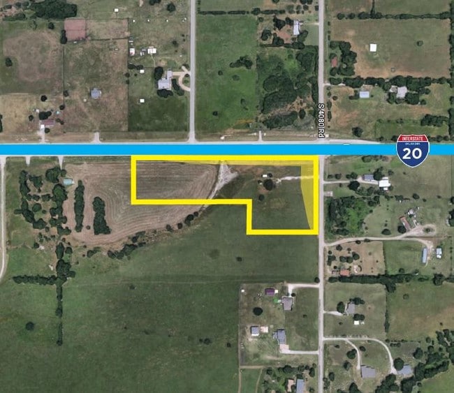

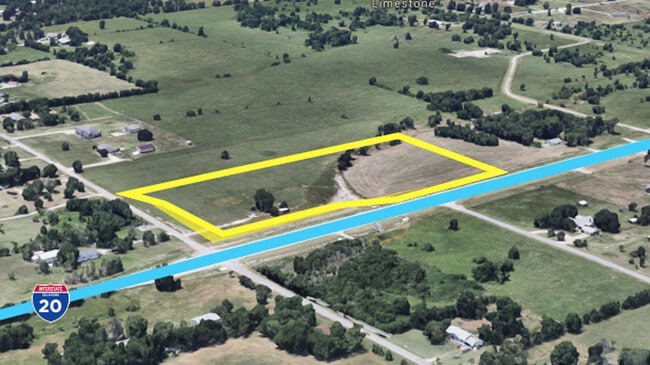
This Property Is For Sale
Property Detail
4674 E Highway 20
Tulsa, OK
E 264' OF NE NW NE; LESS THE N 75' THEREOF.
660080671
Rogers
Residentialacreage
Oklahoma
B and X Area of moderate flood hazard, usually the area between the limits of the 100-year and 500-year floods.
3.54 AC
2025
Rogers County
2025
Tulsa
050403
NEARBY LISTINGS FOR SALE OR LEASE
-
-
View all Claremore listings for sale on LoopNet.com
DEMOGRAPHICS near 4674 E Highway 20
1 mile
3 mile
5 mile
2025 Total Population
834
7,388
28,419
2030 Population
877
7,769
29,698
Pop Growth 2025-2030
+ 5.16%
+ 5.16%
+ 4.50%
Average Age
40
42
40
2025 Total Households
285
2,560
10,133
HH Growth 2025-2030
+ 5.26%
+ 5.20%
+ 4.53%
Median Household Inc
$91,666
$108,213
$91,874
Avg Household Size
2.80
2.80
2.80
2025 Avg HH Vehicles
3.00
3.00
2.00
Median Home Value
$264,666
$312,048
$301,482
Median Year Built
1998
1996
2001
Nearby Places
Map Layers
Map Styles
 Street
 Aerial
Layers
 Traffic
 Biking
Places
Listings with unknown addresses are not visible on the map
- Restaurants
- Banks
- Shops
- Fitness
- Groceries
PUBLIC TRANSPORTATION
AIRPORT
Tulsa International
Drive
Walk
Distance
Tulsa International
21 min
15.4 mi
Freight Ports
Tulsa Port Of Catoosa
Drive
Walk
Distance
Tulsa Port Of Catoosa
18 min
10.0 mi
Nearby Properties
Address
Land Use
TOTAL SIZE
Lot Size
Zoning
Address
Land Use
TOTAL SIZE
Lot Size
Zoning
288 SF
3.95 AC
Address
Land Use
TOTAL SIZE
Lot Size
Zoning
27,000 SF
4.44 AC
Address
Land Use
TOTAL SIZE
Lot Size
Zoning
9,230 SF
1.34 AC
Address
Land Use
TOTAL SIZE
Lot Size
Zoning
22,512 SF
3.62 AC
Address
Land Use
TOTAL SIZE
Lot Size
Zoning
3,390 SF
1.11 AC
Address
Land Use
TOTAL SIZE
Lot Size
Zoning
600 SF
3.04 AC
Address
Land Use
TOTAL SIZE
Lot Size
Zoning
3,309 SF
1.15 AC
Address
Land Use
TOTAL SIZE
Lot Size
Zoning
3,600 SF
2.65 AC
Address
Land Use
TOTAL SIZE
Lot Size
Zoning
7.03 AC
Address
Land Use
TOTAL SIZE
Lot Size
Zoning
3,625 SF
1.25 AC
Address
Land Use
TOTAL SIZE
Lot Size
Zoning
4,064 SF
149.85 AC
Address
Land Use
TOTAL SIZE
Lot Size
Zoning
384 SF
9.01 AC
Address
Land Use
TOTAL SIZE
Lot Size
Zoning
2,765 SF
0.65 AC
Address
Land Use
TOTAL SIZE
Lot Size
Zoning
1,606 SF
1.99 AC
Address
Land Use
TOTAL SIZE
Lot Size
Zoning
5,600 SF
1.07 AC
Address
Land Use
TOTAL SIZE
Lot Size
Zoning
3,870 SF
1.57 AC
Address
Land Use
TOTAL SIZE
Lot Size
Zoning
36.44 AC
Address
Land Use
TOTAL SIZE
Lot Size
Zoning
2,800 SF
2.10 AC
Address
Land Use
TOTAL SIZE
Lot Size
Zoning
920 SF
2.90 AC
Address
Land Use
TOTAL SIZE
Lot Size
Zoning
1.99 AC
Address
Land Use
TOTAL SIZE
Lot Size
Zoning
3,000 SF
0.46 AC
Address
Land Use
TOTAL SIZE
Lot Size
Zoning
Address
Land Use
TOTAL SIZE
Lot Size
Zoning
2.72 AC
Address
Land Use
TOTAL SIZE
Lot Size
Zoning
4.87 AC
Address
Land Use
TOTAL SIZE
Lot Size
Zoning
3.95 AC
Address
Land Use
TOTAL SIZE
Lot Size
Zoning
5.29 AC
Address
Land Use
TOTAL SIZE
Lot Size
Zoning
1,998 SF
4.80 AC
Address
Land Use
TOTAL SIZE
Lot Size
Zoning
3.99 AC
Address
Land Use
TOTAL SIZE
Lot Size
Zoning
6.49 AC
Address
Land Use
TOTAL SIZE
Lot Size
Zoning
984 SF
3.80 AC
The World's #1 Commercial Real Estate Marketplace
Connect with us
© 2026 CoStar Group
The information above has been obtained from sources believed reliable. While we do not doubt its accuracy we have not verified it and make no guarantee, warranty or representation about it. It is your responsibility to independently confirm its accuracy and completeness. Any projections, opinions, assumptions, or estimates used are for example only and do not represent the current or future performance of the property. The value of this transaction to you depends on tax and other factors which should be evaluated by your tax, financial, and legal advisors. You and your advisors should conduct a careful, independent investigation of the property to determine to your satisfaction the suitability of the property for your needs.