Property Record
4675 Walnut Rd, Buckeye Lake, OH 43008
NEARBY LISTINGS FOR SALE OR LEASE
-
-
View all Buckeye Lake listings for sale on LoopNet.com
Property Detail
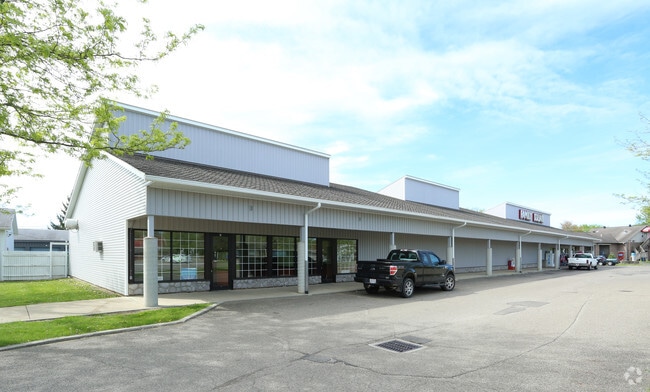
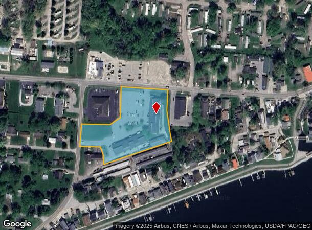
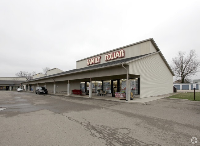
4675 Walnut Rd
074-335652-00.028
Paul D Childers Lands
Communitycenter
TRACT 1-C PAUL D CHILDER'S LANDS REPLAT (3.263 AC)
AE
Licking
39045C0090G
Ohio
2024
3.26 AC
2024
Licking County
758300
Columbus
10,050 SF
Columbus, OH
DEMOGRAPHICS near 4675 Walnut Rd
1 Mile
3 Mile
5 Mile
2024 Total Population
2,637
10,874
17,650
2029 Population
2,793
11,640
18,678
Pop Growth 2024-2029
+ 5.92%
+ 7.04%
+ 5.82%
Average Age
45
45
45
2024 Total Households
1,219
4,848
7,653
HH Growth 2024-2029
+ 5.99%
+ 7.12%
+ 5.98%
Median Household Inc
$69,137
$68,243
$72,802
Avg Household Size
2.20
2.20
2.30
2024 Avg HH Vehicles
2.00
2.00
2.00
Median Home Value
$221,756
$226,097
$264,460
Median Year Built
1972
1971
1975
Nearby Places
Map Layers
Map Styles
 Street
 Aerial
- Restaurants
- Banks
- Shops
- Fitness
- Groceries
PUBLIC TRANSPORTATION
AIRPORT
John Glenn Columbus International
DRIVE
WALK
Distance
John Glenn Columbus International
39 min
30.3 mi
Rickenbacker International
DRIVE
WALK
Distance
Rickenbacker International
42 min
32.5 mi
SALE & LEASE HISTORY
LISTING DATE
SALE/LEASE

Nov 01, 2016
For Sale
Nearby Properties
Address
Land Use
TOTAL SIZE
Lot Size
Zoning
Address
Land Use
TOTAL SIZE
Lot Size
Zoning
50,871 SF
51.13 AC
Address
Land Use
TOTAL SIZE
Lot Size
Zoning
22,425 SF
45.87 AC
Address
Land Use
TOTAL SIZE
Lot Size
Zoning
58,368 SF
25 AC
Address
Land Use
TOTAL SIZE
Lot Size
Zoning
2,067,827 SF
45.19 AC
Address
Land Use
TOTAL SIZE
Lot Size
Zoning
399,520 SF
21.62 AC
Address
Land Use
TOTAL SIZE
Lot Size
Zoning
249,920 SF
13.62 AC
Address
Land Use
TOTAL SIZE
Lot Size
Zoning
616 SF
47.52 AC
Address
Land Use
TOTAL SIZE
Lot Size
Zoning
68,656 SF
7.48 AC
Address
Land Use
TOTAL SIZE
Lot Size
Zoning
134,723 SF
19.93 AC
Address
Land Use
TOTAL SIZE
Lot Size
Zoning
1,109 SF
8.93 AC
Address
Land Use
TOTAL SIZE
Lot Size
Zoning
112,001 SF
10.35 AC
Address
Land Use
TOTAL SIZE
Lot Size
Zoning
82,507 SF
12.43 AC
Address
Land Use
TOTAL SIZE
Lot Size
Zoning
96,407 SF
5 AC
Address
Land Use
TOTAL SIZE
Lot Size
Zoning
2,496 SF
25.95 AC
Address
Land Use
TOTAL SIZE
Lot Size
Zoning
80,000 SF
5.10 AC
Address
Land Use
TOTAL SIZE
Lot Size
Zoning
62,734 SF
2.50 AC
Address
Land Use
TOTAL SIZE
Lot Size
Zoning
48,609 SF
18 AC
Address
Land Use
TOTAL SIZE
Lot Size
Zoning
82,028 SF
25.03 AC
Address
Land Use
TOTAL SIZE
Lot Size
Zoning
24,446 SF
17.36 AC
Address
Land Use
TOTAL SIZE
Lot Size
Zoning
31,984 SF
2.50 AC
Address
Land Use
TOTAL SIZE
Lot Size
Zoning
2,100 SF
7 AC
Address
Land Use
TOTAL SIZE
Lot Size
Zoning
8,425 SF
14.04 AC
Address
Land Use
TOTAL SIZE
Lot Size
Zoning
4,647 SF
4 AC
Address
Land Use
TOTAL SIZE
Lot Size
Zoning
44,277 SF
9.37 AC
Address
Land Use
TOTAL SIZE
Lot Size
Zoning
8,425 SF
27.02 AC
Address
Land Use
TOTAL SIZE
Lot Size
Zoning
640 SF
6 AC
Address
Land Use
TOTAL SIZE
Lot Size
Zoning
8,998 SF
2.90 AC
Address
Land Use
TOTAL SIZE
Lot Size
Zoning
3,112 SF
217.39 AC
Address
Land Use
TOTAL SIZE
Lot Size
Zoning
1,200 SF
3.35 AC
Address
Land Use
TOTAL SIZE
Lot Size
Zoning
6,528 SF
15.03 AC
The World's #1 Commercial Real Estate Marketplace
Connect with us
© 2026 CoStar Group
The information above has been obtained from sources believed reliable. While we do not doubt its accuracy we have not verified it and make no guarantee, warranty or representation about it. It is your responsibility to independently confirm its accuracy and completeness. Any projections, opinions, assumptions, or estimates used are for example only and do not represent the current or future performance of the property. The value of this transaction to you depends on tax and other factors which should be evaluated by your tax, financial, and legal advisors. You and your advisors should conduct a careful, independent investigation of the property to determine to your satisfaction the suitability of the property for your needs.