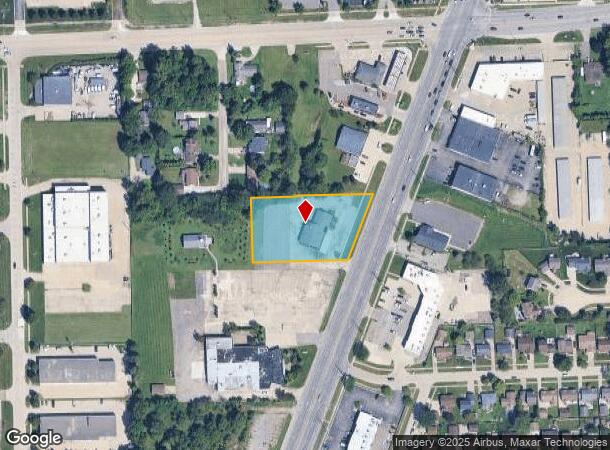
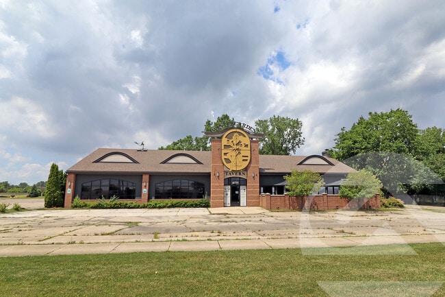
Property Record
46777 Gratiot Ave, Chesterfield, MI 48051

Current Lease Availabilities
NEARBY LISTINGS FOR SALE OR LEASE
Property Detail
46777 Gratiot Ave
15-09-31-103-008
Gratiot
Restaurantbuilding
T3N,R14E SEC 31; COM AT NW COR SEC 31; TH S0*15'W 454.76 FT ALG W SEC LINE; TH N89*33'18"E 339.97 FT TO POB; TH CONT
X
Macomb
26099C0263G
Michigan
2025
1.54 AC
2025
Macomb East
221100
Detroit
5,232 SF
Detroit-Warren-Dearborn, MI
DEMOGRAPHICS near 46777 Gratiot Ave
1 Mile
3 Mile
5 Mile
2024 Total Population
5,776
52,938
154,238
2029 Population
5,765
52,675
153,139
Pop Growth 2024-2029
(0.19%)
(0.50%)
(0.71%)
Average Age
42
39
41
2024 Total Households
2,169
20,392
60,305
HH Growth 2024-2029
(0.28%)
(0.47%)
(0.67%)
Median Household Inc
$99,453
$78,437
$82,904
Avg Household Size
2.60
2.50
2.50
2024 Avg HH Vehicles
2.00
2.00
2.00
Median Home Value
$247,833
$256,123
$269,387
Median Year Built
1993
1995
1991
Nearby Places
Map Layers
Map Styles
 Street
 Aerial
- Restaurants
- Banks
- Shops
- Fitness
- Groceries
PUBLIC TRANSPORTATION
AIRPORT
Windsor International
DRIVE
WALK
Distance
Windsor International
60 min
38.1 mi
Freight Ports
Port of Toledo
DRIVE
WALK
Distance
Port of Toledo
110 min
88.4 mi
Nearby Properties
Address
Land Use
TOTAL SIZE
Lot Size
Zoning
Address
Land Use
TOTAL SIZE
Lot Size
Zoning
122.50 AC
RML
Address
Land Use
TOTAL SIZE
Lot Size
Zoning
20,891 SF
289.61 AC
R3
Address
Land Use
TOTAL SIZE
Lot Size
Zoning
404,160 SF
22.52 AC
I-1
Address
Land Use
TOTAL SIZE
Lot Size
Zoning
44.65 AC
RML
Address
Land Use
TOTAL SIZE
Lot Size
Zoning
181,094 SF
14.89 AC
C3 GEN
Address
Land Use
TOTAL SIZE
Lot Size
Zoning
20.27 AC
RML
Address
Land Use
TOTAL SIZE
Lot Size
Zoning
25.14 AC
RML
Address
Land Use
TOTAL SIZE
Lot Size
Zoning
252,226 SF
52.79 AC
Address
Land Use
TOTAL SIZE
Lot Size
Zoning
26.92 AC
RML
Address
Land Use
TOTAL SIZE
Lot Size
Zoning
670,448 SF
37.23 AC
L-2
Address
Land Use
TOTAL SIZE
Lot Size
Zoning
196,459 SF
19.18 AC
I-1
Address
Land Use
TOTAL SIZE
Lot Size
Zoning
143,731 SF
16.25 AC
C2 SHO
Address
Land Use
TOTAL SIZE
Lot Size
Zoning
229,878 SF
19.93 AC
C4 MULT
Address
Land Use
TOTAL SIZE
Lot Size
Zoning
42,385 SF
25.55 AC
B-2
Address
Land Use
TOTAL SIZE
Lot Size
Zoning
72,572 SF
10 AC
B-3
Address
Land Use
TOTAL SIZE
Lot Size
Zoning
134,327 SF
10.02 AC
I-1
Address
Land Use
TOTAL SIZE
Lot Size
Zoning
167,281 SF
16.12 AC
C3 GEN
Address
Land Use
TOTAL SIZE
Lot Size
Zoning
600 SF
18.79 AC
R2L
Address
Land Use
TOTAL SIZE
Lot Size
Zoning
124,956 SF
15.78 AC
C2 SHO
Address
Land Use
TOTAL SIZE
Lot Size
Zoning
87.32 AC
MH
Address
Land Use
TOTAL SIZE
Lot Size
Zoning
115,349 SF
14.39 AC
C3
Address
Land Use
TOTAL SIZE
Lot Size
Zoning
45,864 SF
4.60 AC
C2
Address
Land Use
TOTAL SIZE
Lot Size
Zoning
149,652 SF
8.04 AC
SP-1
Address
Land Use
TOTAL SIZE
Lot Size
Zoning
322,418 SF
8.08 AC
MU
Address
Land Use
TOTAL SIZE
Lot Size
Zoning
252,226 SF
49.16 AC
Address
Land Use
TOTAL SIZE
Lot Size
Zoning
88,452 SF
8.36 AC
C3 GEN
Address
Land Use
TOTAL SIZE
Lot Size
Zoning
204,318 SF
27.75 AC
C3 GEN
Address
Land Use
TOTAL SIZE
Lot Size
Zoning
136,474 SF
12.62 AC
I-1
Address
Land Use
TOTAL SIZE
Lot Size
Zoning
98,014 SF
8.69 AC
I-1
Address
Land Use
TOTAL SIZE
Lot Size
Zoning
679,606 SF
29.98 AC
M2 GEN
The World's #1 Commercial Real Estate Marketplace
Connect with us
© 2026 CoStar Group
The information above has been obtained from sources believed reliable. While we do not doubt its accuracy we have not verified it and make no guarantee, warranty or representation about it. It is your responsibility to independently confirm its accuracy and completeness. Any projections, opinions, assumptions, or estimates used are for example only and do not represent the current or future performance of the property. The value of this transaction to you depends on tax and other factors which should be evaluated by your tax, financial, and legal advisors. You and your advisors should conduct a careful, independent investigation of the property to determine to your satisfaction the suitability of the property for your needs.