Property Record
46795 E State Highway 96, Avondale, CO 81022
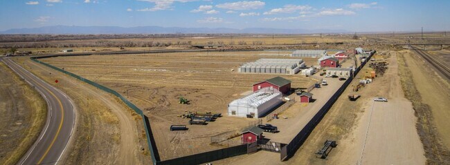


Property Detail
46795 E State Highway 96
0-2-32-0-00-022
A PARCEL OF LAND BEING A PORTION OF THE SW4 SEC 32 +,THE SE4 31-20-62, BEING MORE PARTICULARLY DESCRIBED AS,FOLLOWS: BEGINNING AT A POINT ON THE SLY ROW LN OF THE,MISSOURI PACIFIC RAILROAD FROM WHICH PUEBLO COUNTY GPS,MONUMENT 0231 BEARS N 59 DEG 00
Farms
Pueblo
B and X Area of moderate flood hazard, usually the area between the limits of the 100-year and 500-year floods.
Colorado
2024
36.18 AC
2024
Colorado East Area
003600
Other Market Areas
63,292 SF
Pueblo, CO
NEARBY LISTINGS FOR SALE OR LEASE
-
-
View all Avondale listings for sale on LoopNet.com
DEMOGRAPHICS near 46795 E State Highway 96
1 mile
3 mile
5 mile
2025 Total Population
47
824
1,340
2030 Population
47
825
1,358
Pop Growth 2025-2030
0.00%
+ 0.12%
+ 1.34%
Average Age
44
43
43
2025 Total Households
19
334
539
HH Growth 2025-2030
0.00%
0.00%
+ 1.48%
Median Household Inc
$67,500
$85,156
$85,912
Avg Household Size
2.20
2.40
2.40
2025 Avg HH Vehicles
2.00
2.00
2.00
Median Home Value
$183,333
$250,568
$267,802
Median Year Built
1954
1958
1964
Nearby Places
Map Layers
Map Styles
 Street
 Aerial
Layers
 Traffic
 Biking
Places
Listings with unknown addresses are not visible on the map
- Restaurants
- Banks
- Shops
- Fitness
- Groceries
SALE & LEASE HISTORY
LISTING DATE
SALE/LEASE

May 10, 2023
For Sale
Nearby Properties
Address
Land Use
TOTAL SIZE
Lot Size
Zoning
Address
Land Use
TOTAL SIZE
Lot Size
Zoning
3,093 SF
0.29 AC
B-4
Address
Land Use
TOTAL SIZE
Lot Size
Zoning
988 SF
0.40 AC
R-2
Address
Land Use
TOTAL SIZE
Lot Size
Zoning
20,000 SF
285.50 AC
A-1
Address
Land Use
TOTAL SIZE
Lot Size
Zoning
1,260 SF
0.36 AC
R-2
Address
Land Use
TOTAL SIZE
Lot Size
Zoning
4,524 SF
1.21 AC
R1:RES/1 F
Address
Land Use
TOTAL SIZE
Lot Size
Zoning
5,280 SF
143.50 AC
A-1
Address
Land Use
TOTAL SIZE
Lot Size
Zoning
31,492 SF
14.28 AC
Address
Land Use
TOTAL SIZE
Lot Size
Zoning
Address
Land Use
TOTAL SIZE
Lot Size
Zoning
13,738 SF
136 AC
A-1
Address
Land Use
TOTAL SIZE
Lot Size
Zoning
1,632 SF
0.22 AC
B4:COMM/RE
Address
Land Use
TOTAL SIZE
Lot Size
Zoning
5,540 SF
35 AC
Address
Land Use
TOTAL SIZE
Lot Size
Zoning
3,200 SF
0.33 AC
B4:COMM/RE
Address
Land Use
TOTAL SIZE
Lot Size
Zoning
4,664 SF
6.15 AC
A-2
Address
Land Use
TOTAL SIZE
Lot Size
Zoning
8,695 SF
19 AC
PUD
Address
Land Use
TOTAL SIZE
Lot Size
Zoning
7,453 SF
17.50 AC
PUD
Address
Land Use
TOTAL SIZE
Lot Size
Zoning
8,132 SF
Address
Land Use
TOTAL SIZE
Lot Size
Zoning
15,354 SF
1.93 AC
R2:RES/1 F
Address
Land Use
TOTAL SIZE
Lot Size
Zoning
7,111 SF
17.66 AC
A-1
Address
Land Use
TOTAL SIZE
Lot Size
Zoning
6,109 SF
8.84 AC
A-2
Address
Land Use
TOTAL SIZE
Lot Size
Zoning
2,923 SF
38.64 AC
A-1
Address
Land Use
TOTAL SIZE
Lot Size
Zoning
4,021 SF
1.53 AC
A-1
Address
Land Use
TOTAL SIZE
Lot Size
Zoning
864 SF
128.88 AC
A-1
Address
Land Use
TOTAL SIZE
Lot Size
Zoning
880 SF
139.10 AC
A-1
Address
Land Use
TOTAL SIZE
Lot Size
Zoning
2,621 SF
18.97 AC
A-1
Address
Land Use
TOTAL SIZE
Lot Size
Zoning
4,480 SF
1.26 AC
B4:COMM/RE
Address
Land Use
TOTAL SIZE
Lot Size
Zoning
5,376 SF
37.04 AC
A-1
Address
Land Use
TOTAL SIZE
Lot Size
Zoning
2,931 SF
4.38 AC
Address
Land Use
TOTAL SIZE
Lot Size
Zoning
3,771 SF
16.59 AC
A-1
Address
Land Use
TOTAL SIZE
Lot Size
Zoning
3,167 SF
20 AC
The World's #1 Commercial Real Estate Marketplace
Connect with us
© 2026 CoStar Group
The information above has been obtained from sources believed reliable. While we do not doubt its accuracy we have not verified it and make no guarantee, warranty or representation about it. It is your responsibility to independently confirm its accuracy and completeness. Any projections, opinions, assumptions, or estimates used are for example only and do not represent the current or future performance of the property. The value of this transaction to you depends on tax and other factors which should be evaluated by your tax, financial, and legal advisors. You and your advisors should conduct a careful, independent investigation of the property to determine to your satisfaction the suitability of the property for your needs.