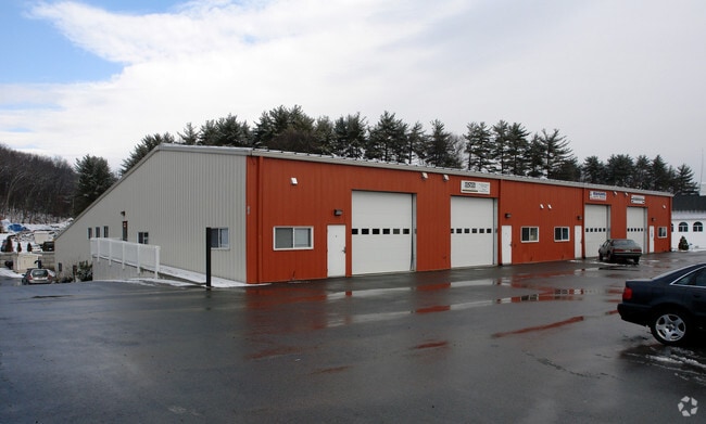
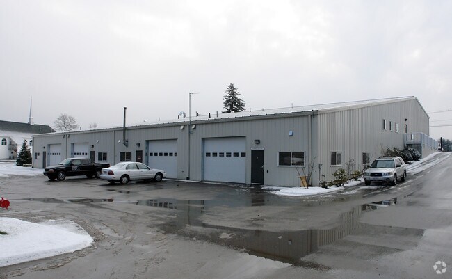
Property Record
469 River Rd, Hudson, MA 01749

Current Lease Availabilities
Property Detail
469 River Rd
HUDS-000071-000000-000005
Middlesex
Autorepair
Massachusetts
M7
5
B and X Area of moderate flood hazard, usually the area between the limits of the 100-year and 500-year floods.
5.66 AC
2025
Concord/Maynard
2025
Boston
322200
Boston-Cambridge-Newton, MA-NH
15,960 SF
NEARBY LISTINGS FOR SALE OR LEASE
DEMOGRAPHICS near 469 River Rd
1 mile
3 mile
5 mile
2025 Total Population
2,439
36,859
86,013
2030 Population
2,559
38,142
89,001
Pop Growth 2025-2030
+ 4.92%
+ 3.48%
+ 3.47%
Average Age
44
42
42
2025 Total Households
974
14,790
33,932
HH Growth 2025-2030
+ 5.03%
+ 3.62%
+ 3.62%
Median Household Inc
$123,780
$105,570
$113,026
Avg Household Size
2.50
2.40
2.50
2025 Avg HH Vehicles
2.00
2.00
2.00
Median Home Value
$639,933
$525,785
$580,035
Median Year Built
1984
1970
1974
Nearby Places
Map Layers
Map Styles
 Street
 Aerial
Layers
 Traffic
 Biking
Places
Listings with unknown addresses are not visible on the map
- Restaurants
- Banks
- Shops
- Fitness
- Groceries
PUBLIC TRANSPORTATION
COMMUTER RAIL
Westborough (Framingham/Worcester Line - Massachusetts Bay Transportation Authority Commuter Rail (Purple Line))
Drive
Walk
Distance
Westborough (Framingham/Worcester Line - Massachusetts Bay Transportation Authority Commuter Rail (Purple Line))
21 min
9.1 mi
AIRPORT
Worcester Regional
Drive
Walk
Distance
Worcester Regional
31 min
19.0 mi
Freight Ports
Port of Boston
Drive
Walk
Distance
Port of Boston
59 min
39.9 mi
Nearby Properties
Address
Land Use
TOTAL SIZE
Lot Size
Zoning
Address
Land Use
TOTAL SIZE
Lot Size
Zoning
284,231 SF
62.04 AC
A2
Address
Land Use
TOTAL SIZE
Lot Size
Zoning
71.70 AC
LI
Address
Land Use
TOTAL SIZE
Lot Size
Zoning
18.73 AC
I
Address
Land Use
TOTAL SIZE
Lot Size
Zoning
13.86 AC
SB
Address
Land Use
TOTAL SIZE
Lot Size
Zoning
54.67 AC
LI
Address
Land Use
TOTAL SIZE
Lot Size
Zoning
24.39 AC
Address
Land Use
TOTAL SIZE
Lot Size
Zoning
267,805 SF
30.74 AC
A2
Address
Land Use
TOTAL SIZE
Lot Size
Zoning
14.80 AC
M6
Address
Land Use
TOTAL SIZE
Lot Size
Zoning
657,045 SF
46.52 AC
LI
Address
Land Use
TOTAL SIZE
Lot Size
Zoning
121,434 SF
21.35 AC
SA8
Address
Land Use
TOTAL SIZE
Lot Size
Zoning
113.78 AC
I
Address
Land Use
TOTAL SIZE
Lot Size
Zoning
188,882 SF
19.37 AC
A3
Address
Land Use
TOTAL SIZE
Lot Size
Zoning
56.73 AC
LI
Address
Land Use
TOTAL SIZE
Lot Size
Zoning
91,722 SF
8.38 AC
A2
Address
Land Use
TOTAL SIZE
Lot Size
Zoning
12.42 AC
M1
Address
Land Use
TOTAL SIZE
Lot Size
Zoning
209,220 SF
19.33 AC
I
Address
Land Use
TOTAL SIZE
Lot Size
Zoning
118,126 SF
82.89 AC
Address
Land Use
TOTAL SIZE
Lot Size
Zoning
283,750 SF
27.03 AC
LI
Address
Land Use
TOTAL SIZE
Lot Size
Zoning
99,619 SF
1.56 AC
B
Address
Land Use
TOTAL SIZE
Lot Size
Zoning
47,301 SF
8.07 AC
Address
Land Use
TOTAL SIZE
Lot Size
Zoning
199,892 SF
46.51 AC
Address
Land Use
TOTAL SIZE
Lot Size
Zoning
119,850 SF
49.66 AC
LC1
Address
Land Use
TOTAL SIZE
Lot Size
Zoning
136,790 SF
11.64 AC
B
Address
Land Use
TOTAL SIZE
Lot Size
Zoning
10,338 SF
4.76 AC
CA
Address
Land Use
TOTAL SIZE
Lot Size
Zoning
215,936 SF
15.63 AC
I
Address
Land Use
TOTAL SIZE
Lot Size
Zoning
174,315 SF
29.04 AC
B
Address
Land Use
TOTAL SIZE
Lot Size
Zoning
196,145 SF
10.18 AC
LI
Address
Land Use
TOTAL SIZE
Lot Size
Zoning
132,659 SF
11.67 AC
I
Address
Land Use
TOTAL SIZE
Lot Size
Zoning
128,838 SF
4.27 AC
RC
Address
Land Use
TOTAL SIZE
Lot Size
Zoning
120,146 SF
7.33 AC
LI
The World's #1 Commercial Real Estate Marketplace
Connect with us
© 2026 CoStar Group
The information above has been obtained from sources believed reliable. While we do not doubt its accuracy we have not verified it and make no guarantee, warranty or representation about it. It is your responsibility to independently confirm its accuracy and completeness. Any projections, opinions, assumptions, or estimates used are for example only and do not represent the current or future performance of the property. The value of this transaction to you depends on tax and other factors which should be evaluated by your tax, financial, and legal advisors. You and your advisors should conduct a careful, independent investigation of the property to determine to your satisfaction the suitability of the property for your needs.