Property Record
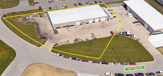
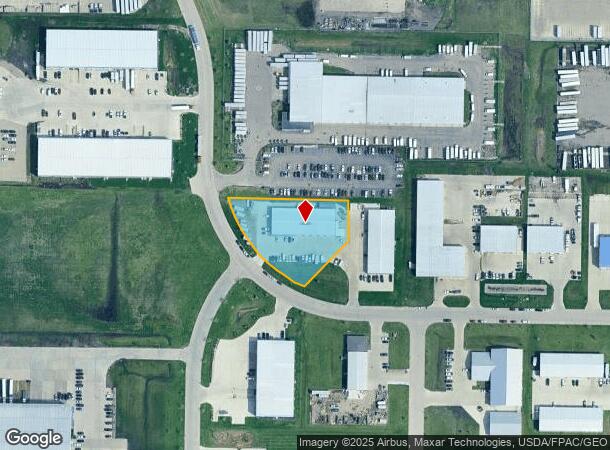
4693 13Th Ave N, Fargo, ND 58102
NEARBY LISTINGS FOR SALE OR LEASE
Property Detail
4693 13Th Ave N
01-7700-00703-000
Fayland Industrial 1St
Realpropertynec
LOT: 7 BLOCK: 1 ADDITION: FAYLAND INDUSTRIAL FIRST ADDITION ADDITIONAL: FAYLAND INDUSTRIAL 1ST LT 7 BLK 1 LESS THE FOLL: BEG
X
Cass
38017C0588G
North Dakota
2024
7
2024
1.18 AC
010107
Other Market Areas
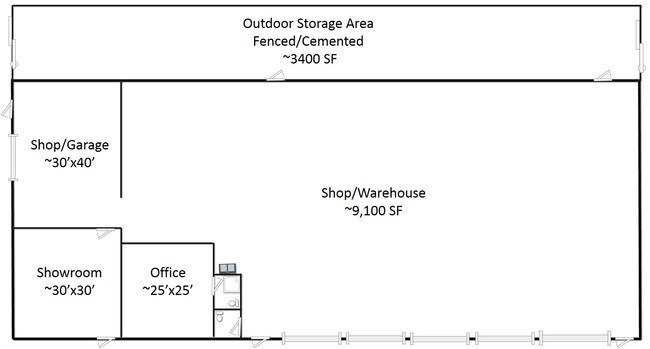
11,900 SF
Fargo, ND-MN
DEMOGRAPHICS near 4693 13Th Ave N
1 Mile
3 Mile
5 Mile
2024 Total Population
71
35,459
137,310
2029 Population
79
37,753
146,638
Pop Growth 2024-2029
+ 11.27%
+ 6.47%
+ 6.79%
Average Age
33
36
36
2024 Total Households
28
15,093
60,674
HH Growth 2024-2029
+ 10.71%
+ 7.42%
+ 7.55%
Median Household Inc
$71,249
$53,412
$59,882
Avg Household Size
2.30
2.10
2.10
2024 Avg HH Vehicles
2.00
2.00
2.00
Median Home Value
$299,999
$212,790
$236,669
Median Year Built
2011
1990
1987
Nearby Places
Map Layers
Map Styles
 Street
 Aerial
- Restaurants
- Banks
- Shops
- Fitness
- Groceries
PUBLIC TRANSPORTATION
COMMUTER RAIL
Fargo Amtrak Station (Empire Builder - Amtrak)
DRIVE
WALK
Distance
Fargo Amtrak Station (Empire Builder - Amtrak)
10 min
4.8 mi
AIRPORT
Hector International
DRIVE
WALK
Distance
Hector International
13 min
6.0 mi
Freight Ports
Port Milwaukee
DRIVE
WALK
Distance
Port Milwaukee
635 min
577.6 mi
SALE & LEASE HISTORY
LISTING DATE
SALE/LEASE

Sep 06, 2017
For Lease
Apr 19, 2017
For Sale
Nearby Properties
Address
Land Use
TOTAL SIZE
Lot Size
Zoning
Address
Land Use
TOTAL SIZE
Lot Size
Zoning
408,617 SF
9.33 AC
GC
Address
Land Use
TOTAL SIZE
Lot Size
Zoning
122,006 SF
24.45 AC
GI
Address
Land Use
TOTAL SIZE
Lot Size
Zoning
230,272 SF
21.77 AC
GC
Address
Land Use
TOTAL SIZE
Lot Size
Zoning
175,969 SF
35.10 AC
GI
Address
Land Use
TOTAL SIZE
Lot Size
Zoning
621,097 SF
49.49 AC
LI
Address
Land Use
TOTAL SIZE
Lot Size
Zoning
109,174 SF
1.25 AC
UMU
Address
Land Use
TOTAL SIZE
Lot Size
Zoning
163,195 SF
11.95 AC
GC
Address
Land Use
TOTAL SIZE
Lot Size
Zoning
45.33 AC
GC
Address
Land Use
TOTAL SIZE
Lot Size
Zoning
12.33 AC
PAC
Address
Land Use
TOTAL SIZE
Lot Size
Zoning
303,970 SF
49.72 AC
GI
Address
Land Use
TOTAL SIZE
Lot Size
Zoning
Address
Land Use
TOTAL SIZE
Lot Size
Zoning
37.39 AC
Address
Land Use
TOTAL SIZE
Lot Size
Zoning
146,131 SF
15.67 AC
GO
Address
Land Use
TOTAL SIZE
Lot Size
Zoning
206,540 SF
16.68 AC
GI
Address
Land Use
TOTAL SIZE
Lot Size
Zoning
104,817 SF
13.93 AC
GC
Address
Land Use
TOTAL SIZE
Lot Size
Zoning
190,588 SF
6.32 AC
Address
Land Use
TOTAL SIZE
Lot Size
Zoning
75 AC
MHP
Address
Land Use
TOTAL SIZE
Lot Size
Zoning
218,579 SF
21.28 AC
GC
Address
Land Use
TOTAL SIZE
Lot Size
Zoning
49.50 AC
Address
Land Use
TOTAL SIZE
Lot Size
Zoning
152,508 SF
13.85 AC
GI
Address
Land Use
TOTAL SIZE
Lot Size
Zoning
155,989 SF
11.62 AC
GC
Address
Land Use
TOTAL SIZE
Lot Size
Zoning
193,488 SF
8.27 AC
GC
Address
Land Use
TOTAL SIZE
Lot Size
Zoning
15,895 SF
41.76 AC
Address
Land Use
TOTAL SIZE
Lot Size
Zoning
184,560 SF
17.11 AC
Address
Land Use
TOTAL SIZE
Lot Size
Zoning
135,235 SF
6.01 AC
GC
Address
Land Use
TOTAL SIZE
Lot Size
Zoning
34,757 SF
1.34 AC
MR3
Address
Land Use
TOTAL SIZE
Lot Size
Zoning
99,300 SF
12.72 AC
Address
Land Use
TOTAL SIZE
Lot Size
Zoning
Address
Land Use
TOTAL SIZE
Lot Size
Zoning
207,189 SF
23.72 AC
Address
Land Use
TOTAL SIZE
Lot Size
Zoning
12.97 AC
GI
The World's #1 Commercial Real Estate Marketplace
Connect with us
© 2025 CoStar Group
The information above has been obtained from sources believed reliable. While we do not doubt its accuracy we have not verified it and make no guarantee, warranty or representation about it. It is your responsibility to independently confirm its accuracy and completeness. Any projections, opinions, assumptions, or estimates used are for example only and do not represent the current or future performance of the property. The value of this transaction to you depends on tax and other factors which should be evaluated by your tax, financial, and legal advisors. You and your advisors should conduct a careful, independent investigation of the property to determine to your satisfaction the suitability of the property for your needs.