Property Record
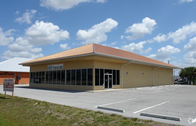
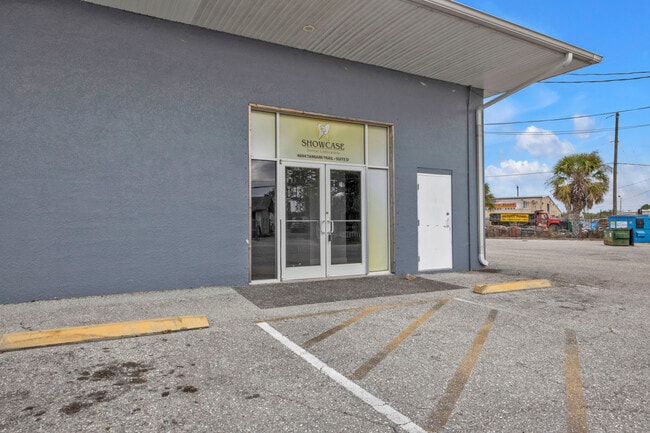
4694 Tamiami Trl, Punta Gorda, FL 33980

Current Lease Availabilities
NEARBY LISTINGS FOR SALE OR LEASE
Property Detail
4694 Tamiami Trl
Punta Gorda, FL
Wilsons Add Char Harb
402225376005
WILSONS ADD CHAR HARB BLK 38 LT 6 & PART LTS 7 & 8 326/859 362/181 536/72 E544/1779 663/2065 1026/963 UNREC DC-JDR 1523/13161567/548 1567/550 1567/556 2660/1271 WSA 000 0038 0005 WILSONS ADD C HARB BLK 38 BEG NE COR LT 5 W 82.5FT SW 47.5FT CONT
Storemultistory
Charlotte
AE
Florida
12015C0229G
6,7,8
2024
0.60 AC
2025
Charlotte County
021003
Southwest Florida
6,996 SF
DEMOGRAPHICS near 4694 Tamiami Trl
1 Mile
3 Mile
5 Mile
2024 Total Population
3,352
34,774
100,622
2029 Population
4,058
41,742
120,292
Pop Growth 2024-2029
+ 21.06%
+ 20.04%
+ 19.55%
Average Age
54
52
52
2024 Total Households
1,712
16,296
46,441
HH Growth 2024-2029
+ 21.50%
+ 20.49%
+ 19.90%
Median Household Inc
$41,007
$51,114
$57,345
Avg Household Size
1.80
2.00
2.10
2024 Avg HH Vehicles
1.00
2.00
2.00
Median Home Value
$172,867
$205,959
$247,308
Median Year Built
1981
1980
1986
Nearby Places
- Restaurants
- Banks
- Shops
- Fitness
- Groceries
PUBLIC TRANSPORTATION
AIRPORT
Punta Gorda
DRIVE
WALK
Distance
Punta Gorda
13 min
6.7 mi
Freight Ports
Port Manatee
DRIVE
WALK
Distance
Port Manatee
83 min
68.7 mi
Nearby Properties
Address
Land Use
TOTAL SIZE
Lot Size
Zoning
Address
Land Use
TOTAL SIZE
Lot Size
Zoning
333,027 SF
9.79 AC
CHRW
Address
Land Use
TOTAL SIZE
Lot Size
Zoning
349,844 SF
78.47 AC
P
Address
Land Use
TOTAL SIZE
Lot Size
Zoning
156,350 SF
12.49 AC
OMI
Address
Land Use
TOTAL SIZE
Lot Size
Zoning
129,475 SF
16.04 AC
OMI
Address
Land Use
TOTAL SIZE
Lot Size
Zoning
77,154 SF
10.30 AC
CC
Address
Land Use
TOTAL SIZE
Lot Size
Zoning
121,585 SF
696.03 AC
RE1
Address
Land Use
TOTAL SIZE
Lot Size
Zoning
172,298 SF
37.42 AC
OMI
Address
Land Use
TOTAL SIZE
Lot Size
Zoning
789,392 SF
31.39 AC
RMF15
Address
Land Use
TOTAL SIZE
Lot Size
Zoning
47,443 SF
7.94 AC
CC
Address
Land Use
TOTAL SIZE
Lot Size
Zoning
238,852 SF
26.63 AC
CG
Address
Land Use
TOTAL SIZE
Lot Size
Zoning
15,253 SF
13.27 AC
P
Address
Land Use
TOTAL SIZE
Lot Size
Zoning
40,430 SF
5.63 AC
RMF12
Address
Land Use
TOTAL SIZE
Lot Size
Zoning
6,313 SF
15.49 AC
P
Address
Land Use
TOTAL SIZE
Lot Size
Zoning
73,095 SF
5 AC
NC
Address
Land Use
TOTAL SIZE
Lot Size
Zoning
44,185 SF
1.22 AC
CC
Address
Land Use
TOTAL SIZE
Lot Size
Zoning
128,594 SF
25.54 AC
PD
Address
Land Use
TOTAL SIZE
Lot Size
Zoning
25,356 SF
1.40 AC
CC
Address
Land Use
TOTAL SIZE
Lot Size
Zoning
70,518 SF
2.08 AC
PD
Address
Land Use
TOTAL SIZE
Lot Size
Zoning
12,101 SF
15.92 AC
ES
Address
Land Use
TOTAL SIZE
Lot Size
Zoning
82,379 SF
0.88 AC
CC
Address
Land Use
TOTAL SIZE
Lot Size
Zoning
12,159 SF
0.56 AC
CC
Address
Land Use
TOTAL SIZE
Lot Size
Zoning
24,880 SF
84.50 AC
PKR
Address
Land Use
TOTAL SIZE
Lot Size
Zoning
1,296 SF
14.46 AC
CG
Address
Land Use
TOTAL SIZE
Lot Size
Zoning
34,975 SF
2.90 AC
RMF15
Address
Land Use
TOTAL SIZE
Lot Size
Zoning
35,587 SF
6.27 AC
RMF15
Address
Land Use
TOTAL SIZE
Lot Size
Zoning
43,755 SF
8.19 AC
CC
Address
Land Use
TOTAL SIZE
Lot Size
Zoning
30,472 SF
3.19 AC
NR-10
Address
Land Use
TOTAL SIZE
Lot Size
Zoning
81,167 SF
5.63 AC
CG
Address
Land Use
TOTAL SIZE
Lot Size
Zoning
30,940 SF
0.42 AC
NC
Address
Land Use
TOTAL SIZE
Lot Size
Zoning
448 SF
16.37 AC
PD
The World's #1 Commercial Real Estate Marketplace
Connect with us
© 2025 CoStar Group
The information above has been obtained from sources believed reliable. While we do not doubt its accuracy we have not verified it and make no guarantee, warranty or representation about it. It is your responsibility to independently confirm its accuracy and completeness. Any projections, opinions, assumptions, or estimates used are for example only and do not represent the current or future performance of the property. The value of this transaction to you depends on tax and other factors which should be evaluated by your tax, financial, and legal advisors. You and your advisors should conduct a careful, independent investigation of the property to determine to your satisfaction the suitability of the property for your needs.