Property Record
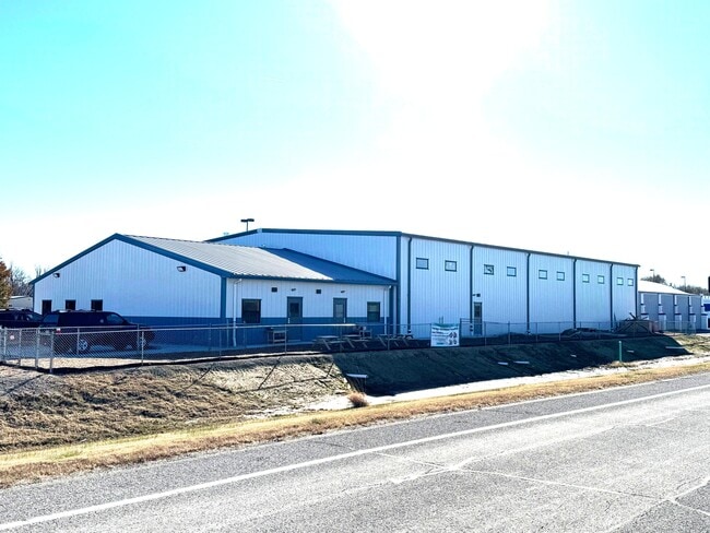
4701 Stagg Hill Rd, Manhattan, KS 66502


Property Detail
4701 Stagg Hill Rd
218-27-0-00-00-012.00-0
STAGG HILL BUSINESS COMMUNITY ADDITION, S27, T10, R07E, LOT 2, 55993 SQUARE FEET, K-980, 894/4188-AFFIDAVIT OF ERROR ON PLAT
Warehouse
Riley
D2
Kansas
AE The base floodplain where base flood elevations are provided. AE Zones are now used on new format FIRMs instead of A1-A30 Zones.
2
2024
1.29 AC
2025
Kansas Area
000900
Other Market Areas
7,200 SF
Manhattan, KS
NEARBY LISTINGS FOR SALE OR LEASE
-
-
View all Manhattan listings for lease on LoopNet.com
DEMOGRAPHICS near 4701 Stagg Hill Rd
1 mile
3 mile
5 mile
2025 Total Population
488
11,299
47,932
2030 Population
498
11,445
48,402
Pop Growth 2025-2030
+ 2.05%
+ 1.29%
+ 0.98%
Average Age
39
37
34
2025 Total Households
170
4,479
19,079
HH Growth 2025-2030
+ 1.76%
+ 1.18%
+ 1.07%
Median Household Inc
$95,126
$85,670
$62,986
Avg Household Size
2.70
2.40
2.20
2025 Avg HH Vehicles
2.00
2.00
2.00
Median Home Value
$353,906
$348,680
$284,976
Median Year Built
2008
2000
1982
Nearby Places
Map Layers
Map Styles
 Street
 Aerial
Layers
 Traffic
 Biking
Places
Listings with unknown addresses are not visible on the map
- Restaurants
- Banks
- Shops
- Fitness
- Groceries
PUBLIC TRANSPORTATION
AIRPORT
Manhattan Regional
Drive
Walk
Distance
Manhattan Regional
10 min
4.0 mi
SALE & LEASE HISTORY
LISTING DATE
SALE/LEASE

Sep 13, 2025
For Lease
Dec 04, 2024
For Sale
Nearby Properties
Address
Land Use
TOTAL SIZE
Lot Size
Zoning
Address
Land Use
TOTAL SIZE
Lot Size
Zoning
32,402 SF
5.76 AC
R
Address
Land Use
TOTAL SIZE
Lot Size
Zoning
56,522 SF
17.60 AC
ROW
Address
Land Use
TOTAL SIZE
Lot Size
Zoning
23,900 SF
4.51 AC
I3
Address
Land Use
TOTAL SIZE
Lot Size
Zoning
42,878 SF
8.75 AC
I5
Address
Land Use
TOTAL SIZE
Lot Size
Zoning
54,232 SF
1.53 AC
PUD
Address
Land Use
TOTAL SIZE
Lot Size
Zoning
25,764 SF
7.63 AC
R
Address
Land Use
TOTAL SIZE
Lot Size
Zoning
57,317 SF
9.32 AC
C5
Address
Land Use
TOTAL SIZE
Lot Size
Zoning
123,150 SF
12.55 AC
PUD
Address
Land Use
TOTAL SIZE
Lot Size
Zoning
200,158 SF
20.07 AC
I3
Address
Land Use
TOTAL SIZE
Lot Size
Zoning
24,519 SF
4.82 AC
N1
Address
Land Use
TOTAL SIZE
Lot Size
Zoning
71,669 SF
5.14 AC
PUD
Address
Land Use
TOTAL SIZE
Lot Size
Zoning
97,241 SF
12.10 AC
PUD
Address
Land Use
TOTAL SIZE
Lot Size
Zoning
24,120 SF
0.98 AC
PUD
Address
Land Use
TOTAL SIZE
Lot Size
Zoning
21,326 SF
1.08 AC
PUD
Address
Land Use
TOTAL SIZE
Lot Size
Zoning
82,503 SF
12.40 AC
PUD
Address
Land Use
TOTAL SIZE
Lot Size
Zoning
2,511 SF
180.75 AC
AG
Address
Land Use
TOTAL SIZE
Lot Size
Zoning
6,579 SF
88.68 AC
C1
Address
Land Use
TOTAL SIZE
Lot Size
Zoning
69,765 SF
5.91 AC
C5
Address
Land Use
TOTAL SIZE
Lot Size
Zoning
1,152 SF
98.80 AC
AG
Address
Land Use
TOTAL SIZE
Lot Size
Zoning
14,645 SF
8.74 AC
SF1
Address
Land Use
TOTAL SIZE
Lot Size
Zoning
7,178 SF
0.33 AC
Address
Land Use
TOTAL SIZE
Lot Size
Zoning
22,729 SF
3.11 AC
PUD
Address
Land Use
TOTAL SIZE
Lot Size
Zoning
148,975 SF
7.63 AC
C5
Address
Land Use
TOTAL SIZE
Lot Size
Zoning
0.71 AC
R
Address
Land Use
TOTAL SIZE
Lot Size
Zoning
7,242 SF
2.03 AC
C2
Address
Land Use
TOTAL SIZE
Lot Size
Zoning
1,600 SF
66.80 AC
R5
Address
Land Use
TOTAL SIZE
Lot Size
Zoning
53,602 SF
5.85 AC
I3
Address
Land Use
TOTAL SIZE
Lot Size
Zoning
22,087 SF
4.45 AC
C2
Address
Land Use
TOTAL SIZE
Lot Size
Zoning
15,960 SF
3.05 AC
PUD
Address
Land Use
TOTAL SIZE
Lot Size
Zoning
3,834 SF
1.15 AC
C2
The World's #1 Commercial Real Estate Marketplace
Connect with us
© 2026 CoStar Group
The information above has been obtained from sources believed reliable. While we do not doubt its accuracy we have not verified it and make no guarantee, warranty or representation about it. It is your responsibility to independently confirm its accuracy and completeness. Any projections, opinions, assumptions, or estimates used are for example only and do not represent the current or future performance of the property. The value of this transaction to you depends on tax and other factors which should be evaluated by your tax, financial, and legal advisors. You and your advisors should conduct a careful, independent investigation of the property to determine to your satisfaction the suitability of the property for your needs.