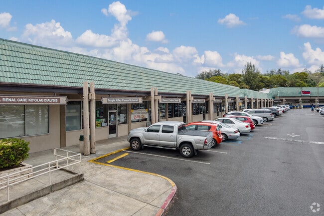
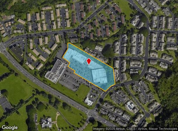
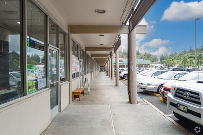
Property Record
47-388 Hui Iwa St, Kaneohe, HI 96744
NEARBY LISTINGS FOR SALE OR LEASE
Property Detail
47-388 Hui Iwa St
Urban Honolulu, HI
Arco
1-4-7-004-025-0000
LOT 198 MAP 60 LCAPP 1805 207,125 SF TOG/E
Commercialnec
Honolulu
D
Hawaii
15003C0270J
198
2024
4.76 AC
2025
Windward
010310
Hawaii
139,362 SF
DEMOGRAPHICS near 47-388 Hui Iwa St
1 Mile
3 Mile
5 Mile
2024 Total Population
6,802
38,421
54,578
2029 Population
6,300
36,545
51,888
Pop Growth 2024-2029
(7.38%)
(4.88%)
(4.93%)
Average Age
43
42
42
2024 Total Households
2,143
12,032
16,661
HH Growth 2024-2029
(8.59%)
(5.76%)
(5.97%)
Median Household Inc
$130,357
$118,009
$120,283
Avg Household Size
3.00
3.00
3.00
2024 Avg HH Vehicles
2.00
2.00
2.00
Median Home Value
$808,939
$816,580
$843,045
Median Year Built
1974
1973
1973
Nearby Places
Map Layers
Map Styles
 Street
 Aerial
- Restaurants
- Banks
- Shops
- Fitness
- Groceries
PUBLIC TRANSPORTATION
AIRPORT
Daniel K Inouye International
DRIVE
WALK
Distance
Daniel K Inouye International
27 min
13.5 mi
Freight Ports
Honolulu Harbor, Oahu
DRIVE
WALK
Distance
Honolulu Harbor, Oahu
30 min
14.3 mi
SALE & LEASE HISTORY
LISTING DATE
SALE/LEASE

Mar 21, 2017
For Lease
Nearby Properties
Address
Land Use
TOTAL SIZE
Lot Size
Zoning
Address
Land Use
TOTAL SIZE
Lot Size
Zoning
370,415 SF
9.03 AC
B-2
Address
Land Use
TOTAL SIZE
Lot Size
Zoning
118,302 SF
9.55 AC
B-2
Address
Land Use
TOTAL SIZE
Lot Size
Zoning
86.85 AC
AG-2
Address
Land Use
TOTAL SIZE
Lot Size
Zoning
128,707 SF
4.57 AC
B-2
Address
Land Use
TOTAL SIZE
Lot Size
Zoning
88,447 SF
4.41 AC
B-2
Address
Land Use
TOTAL SIZE
Lot Size
Zoning
85,618 SF
4.82 AC
B-2
Address
Land Use
TOTAL SIZE
Lot Size
Zoning
59,491 SF
1.55 AC
B-2
Address
Land Use
TOTAL SIZE
Lot Size
Zoning
52,880 SF
3.47 AC
B-2
Address
Land Use
TOTAL SIZE
Lot Size
Zoning
52.93 AC
AG-2
Address
Land Use
TOTAL SIZE
Lot Size
Zoning
64.05 AC
AG-2
Address
Land Use
TOTAL SIZE
Lot Size
Zoning
3.21 AC
B-2
Address
Land Use
TOTAL SIZE
Lot Size
Zoning
38,744 SF
2.11 AC
B-2
Address
Land Use
TOTAL SIZE
Lot Size
Zoning
17,510 SF
2.63 AC
B-2
Address
Land Use
TOTAL SIZE
Lot Size
Zoning
36,640 SF
3.49 AC
B-1
Address
Land Use
TOTAL SIZE
Lot Size
Zoning
66,451 SF
1.49 AC
B-2
Address
Land Use
TOTAL SIZE
Lot Size
Zoning
20,444 SF
0.53 AC
B-2
Address
Land Use
TOTAL SIZE
Lot Size
Zoning
69,403 SF
0.65 AC
B-2
Address
Land Use
TOTAL SIZE
Lot Size
Zoning
8,206 SF
5.88 AC
P-2
Address
Land Use
TOTAL SIZE
Lot Size
Zoning
10,383 SF
1.80 AC
B-2
Address
Land Use
TOTAL SIZE
Lot Size
Zoning
56,250 SF
2.17 AC
I-2
Address
Land Use
TOTAL SIZE
Lot Size
Zoning
224.76 AC
P-1
Address
Land Use
TOTAL SIZE
Lot Size
Zoning
16,524 SF
1.17 AC
B-2
Address
Land Use
TOTAL SIZE
Lot Size
Zoning
2.88 AC
I-2
Address
Land Use
TOTAL SIZE
Lot Size
Zoning
3,498 SF
2.12 AC
B-1
Address
Land Use
TOTAL SIZE
Lot Size
Zoning
15,375 SF
1.16 AC
B-2
Address
Land Use
TOTAL SIZE
Lot Size
Zoning
31,000 SF
2.16 AC
I-2
Address
Land Use
TOTAL SIZE
Lot Size
Zoning
1.34 AC
B-2
Address
Land Use
TOTAL SIZE
Lot Size
Zoning
12,617 SF
0.99 AC
B-2
Address
Land Use
TOTAL SIZE
Lot Size
Zoning
17,066 SF
0.42 AC
B-2
The World's #1 Commercial Real Estate Marketplace
Connect with us
© 2025 CoStar Group
The information above has been obtained from sources believed reliable. While we do not doubt its accuracy we have not verified it and make no guarantee, warranty or representation about it. It is your responsibility to independently confirm its accuracy and completeness. Any projections, opinions, assumptions, or estimates used are for example only and do not represent the current or future performance of the property. The value of this transaction to you depends on tax and other factors which should be evaluated by your tax, financial, and legal advisors. You and your advisors should conduct a careful, independent investigation of the property to determine to your satisfaction the suitability of the property for your needs.