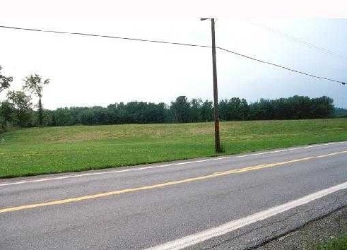
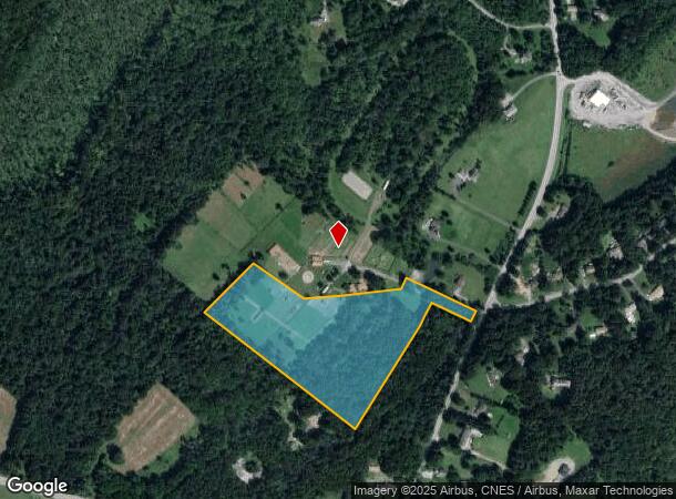
Property Record
47 Collabar Rd, Montgomery, NY 12549
NEARBY LISTINGS FOR SALE OR LEASE
Property Detail
47 Collabar Rd
New York-Jersey City-White Plains, NY-NJ
Dapple Gray Farms
332600-020-000-0001-060.000-0000
SEC 6 DAPPLE GRAY FARMS
Recreationalacreage
Orange
X
New York
36071C0090E
60.00
2024
12.20 AC
2024
Middletown
010902
Northern New Jersey
2,074 SF
DEMOGRAPHICS near 47 Collabar Rd
1 Mile
3 Mile
5 Mile
2024 Total Population
680
4,444
22,210
2029 Population
674
4,456
22,440
Pop Growth 2024-2029
(0.88%)
+ 0.27%
+ 1.04%
Average Age
41
41
41
2024 Total Households
239
1,545
7,886
HH Growth 2024-2029
(0.84%)
+ 0.39%
+ 1.10%
Median Household Inc
$117,129
$112,162
$105,429
Avg Household Size
2.80
2.80
2.70
2024 Avg HH Vehicles
2.00
2.00
2.00
Median Home Value
$360,810
$371,672
$336,672
Median Year Built
1986
1980
1977
Nearby Places
- Restaurants
- Banks
- Shops
- Fitness
- Groceries
PUBLIC TRANSPORTATION
COMMUTER RAIL
Middletown New York (Bergen County/Port Jervis Line - NJ Transit Commuter Rail (NJ Transit), Main/Port Jervis Line - NJ Transit Commuter Rail (NJ Transit))
DRIVE
WALK
Distance
Middletown New York (Bergen County/Port Jervis Line - NJ Transit Commuter Rail (NJ Transit), Main/Port Jervis Line - NJ Transit Commuter Rail (NJ Transit))
18 min
8.1 mi
AIRPORT
New York Stewart International
DRIVE
WALK
Distance
New York Stewart International
23 min
14.5 mi
Freight Ports
Port Newark Container Terminal
DRIVE
WALK
Distance
Port Newark Container Terminal
104 min
79.7 mi
Nearby Properties
Address
Land Use
TOTAL SIZE
Lot Size
Zoning
Address
Land Use
TOTAL SIZE
Lot Size
Zoning
152.90 AC
Address
Land Use
TOTAL SIZE
Lot Size
Zoning
5,484 SF
129 AC
07
Address
Land Use
TOTAL SIZE
Lot Size
Zoning
4,559 SF
216.50 AC
RA-.5
Address
Land Use
TOTAL SIZE
Lot Size
Zoning
20 AC
07
Address
Land Use
TOTAL SIZE
Lot Size
Zoning
34,268 SF
8.30 AC
B
Address
Land Use
TOTAL SIZE
Lot Size
Zoning
19.90 AC
RA07
Address
Land Use
TOTAL SIZE
Lot Size
Zoning
4,246 SF
282 AC
RA5
Address
Land Use
TOTAL SIZE
Lot Size
Zoning
8,514 SF
81.40 AC
RA-.5
Address
Land Use
TOTAL SIZE
Lot Size
Zoning
Address
Land Use
TOTAL SIZE
Lot Size
Zoning
18.80 AC
07
Address
Land Use
TOTAL SIZE
Lot Size
Zoning
7,023 SF
174.60 AC
RA5
Address
Land Use
TOTAL SIZE
Lot Size
Zoning
Address
Land Use
TOTAL SIZE
Lot Size
Zoning
20,056 SF
12.70 AC
B
Address
Land Use
TOTAL SIZE
Lot Size
Zoning
8,136 SF
35 AC
07
Address
Land Use
TOTAL SIZE
Lot Size
Zoning
73.60 AC
07
Address
Land Use
TOTAL SIZE
Lot Size
Zoning
246.20 AC
Address
Land Use
TOTAL SIZE
Lot Size
Zoning
Address
Land Use
TOTAL SIZE
Lot Size
Zoning
10.90 AC
Address
Land Use
TOTAL SIZE
Lot Size
Zoning
1,488 SF
138 AC
RA5
Address
Land Use
TOTAL SIZE
Lot Size
Zoning
1,012 SF
131.57 AC
RA5
Address
Land Use
TOTAL SIZE
Lot Size
Zoning
17.80 AC
Address
Land Use
TOTAL SIZE
Lot Size
Zoning
5,180 SF
141.20 AC
RA
Address
Land Use
TOTAL SIZE
Lot Size
Zoning
Address
Land Use
TOTAL SIZE
Lot Size
Zoning
1,872 SF
124 AC
RA5
Address
Land Use
TOTAL SIZE
Lot Size
Zoning
16,000 SF
14.70 AC
RA07
Address
Land Use
TOTAL SIZE
Lot Size
Zoning
3,057 SF
91.10 AC
RA
Address
Land Use
TOTAL SIZE
Lot Size
Zoning
6.50 AC
07
Address
Land Use
TOTAL SIZE
Lot Size
Zoning
3,166 SF
123 AC
RA
Address
Land Use
TOTAL SIZE
Lot Size
Zoning
Address
Land Use
TOTAL SIZE
Lot Size
Zoning
2,768 SF
93.10 AC
The World's #1 Commercial Real Estate Marketplace
Connect with us
© 2025 CoStar Group
The information above has been obtained from sources believed reliable. While we do not doubt its accuracy we have not verified it and make no guarantee, warranty or representation about it. It is your responsibility to independently confirm its accuracy and completeness. Any projections, opinions, assumptions, or estimates used are for example only and do not represent the current or future performance of the property. The value of this transaction to you depends on tax and other factors which should be evaluated by your tax, financial, and legal advisors. You and your advisors should conduct a careful, independent investigation of the property to determine to your satisfaction the suitability of the property for your needs.