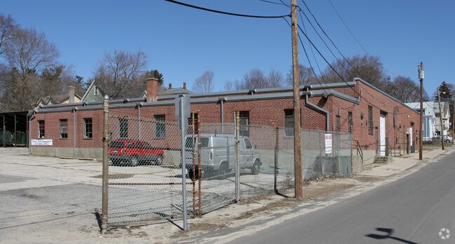
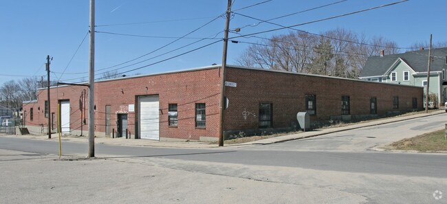
Property Record
47 Liberty St, East Greenwich, RI 02818

NEARBY LISTINGS FOR SALE OR LEASE
Property Detail
47 Liberty St
EGRE-000075-000003-000275
Kent
Commercialbuilding
Rhode Island
X
275
44003C0137H
0.93 AC
2025
East Greenwich
2025
Providence
020901
Providence-Warwick, RI-MA
16,416 SF
DEMOGRAPHICS near 47 Liberty St
1 Mile
3 Mile
5 Mile
2024 Total Population
5,599
32,784
99,791
2029 Population
5,634
33,101
100,951
Pop Growth 2024-2029
+ 0.63%
+ 0.97%
+ 1.16%
Average Age
44
45
43
2024 Total Households
2,688
14,311
43,010
HH Growth 2024-2029
+ 0.56%
+ 0.89%
+ 1.13%
Median Household Inc
$102,462
$91,719
$73,349
Avg Household Size
2.10
2.20
2.30
2024 Avg HH Vehicles
2.00
2.00
2.00
Median Home Value
$462,085
$422,828
$335,372
Median Year Built
1953
1968
1968
Nearby Places
Map Layers
Map Styles
 Street
 Aerial
- Restaurants
- Banks
- Shops
- Fitness
- Groceries
PUBLIC TRANSPORTATION
AIRPORT
Rhode Island Tf Green International
DRIVE
WALK
Distance
Rhode Island Tf Green International
21 min
11.2 mi
Freight Ports
Port of Davisville, RI
DRIVE
WALK
Distance
Port of Davisville, RI
1 min
3.7 mi
Nearby Properties
Address
Land Use
TOTAL SIZE
Lot Size
Zoning
Address
Land Use
TOTAL SIZE
Lot Size
Zoning
24,276 SF
0.01 AC
A15
Address
Land Use
TOTAL SIZE
Lot Size
Zoning
6,640 SF
0.01 AC
A10
Address
Land Use
TOTAL SIZE
Lot Size
Zoning
283,536 SF
97.97 AC
O
Address
Land Use
TOTAL SIZE
Lot Size
Zoning
19.60 AC
CH
Address
Land Use
TOTAL SIZE
Lot Size
Zoning
18,720 SF
15 AC
PDR
Address
Land Use
TOTAL SIZE
Lot Size
Zoning
3,743 SF
A15
Address
Land Use
TOTAL SIZE
Lot Size
Zoning
Address
Land Use
TOTAL SIZE
Lot Size
Zoning
20.43 AC
MUPD
Address
Land Use
TOTAL SIZE
Lot Size
Zoning
541,370 SF
34.08 AC
CI
Address
Land Use
TOTAL SIZE
Lot Size
Zoning
25,632 SF
A15
Address
Land Use
TOTAL SIZE
Lot Size
Zoning
10,375 SF
75.99 AC
A10
Address
Land Use
TOTAL SIZE
Lot Size
Zoning
19.65 AC
BP
Address
Land Use
TOTAL SIZE
Lot Size
Zoning
161,263 SF
61.75 AC
R30
Address
Land Use
TOTAL SIZE
Lot Size
Zoning
63.69 AC
LI
Address
Land Use
TOTAL SIZE
Lot Size
Zoning
107,212 SF
18.50 AC
R10
Address
Land Use
TOTAL SIZE
Lot Size
Zoning
137,323 SF
22.84 AC
PR
Address
Land Use
TOTAL SIZE
Lot Size
Zoning
97,308 SF
9.36 AC
P
Address
Land Use
TOTAL SIZE
Lot Size
Zoning
5.31 AC
M/LI
Address
Land Use
TOTAL SIZE
Lot Size
Zoning
160,971 SF
175 AC
A15
Address
Land Use
TOTAL SIZE
Lot Size
Zoning
83.12 AC
MLIO
Address
Land Use
TOTAL SIZE
Lot Size
Zoning
9,216 SF
A7
Address
Land Use
TOTAL SIZE
Lot Size
Zoning
147,866 SF
6.08 AC
A7
Address
Land Use
TOTAL SIZE
Lot Size
Zoning
147,866 SF
A7
Address
Land Use
TOTAL SIZE
Lot Size
Zoning
137,511 SF
14.80 AC
GB
Address
Land Use
TOTAL SIZE
Lot Size
Zoning
116,034 SF
10.65 AC
B
Address
Land Use
TOTAL SIZE
Lot Size
Zoning
60,324 SF
4.39 AC
BP
Address
Land Use
TOTAL SIZE
Lot Size
Zoning
28.16 AC
B
Address
Land Use
TOTAL SIZE
Lot Size
Zoning
48,468 SF
4.50 AC
M/LI
Address
Land Use
TOTAL SIZE
Lot Size
Zoning
4,622 SF
473.27 AC
OS
Address
Land Use
TOTAL SIZE
Lot Size
Zoning
112,179 SF
13.45 AC
PR
The World's #1 Commercial Real Estate Marketplace
Connect with us
© 2025 CoStar Group
The information above has been obtained from sources believed reliable. While we do not doubt its accuracy we have not verified it and make no guarantee, warranty or representation about it. It is your responsibility to independently confirm its accuracy and completeness. Any projections, opinions, assumptions, or estimates used are for example only and do not represent the current or future performance of the property. The value of this transaction to you depends on tax and other factors which should be evaluated by your tax, financial, and legal advisors. You and your advisors should conduct a careful, independent investigation of the property to determine to your satisfaction the suitability of the property for your needs.