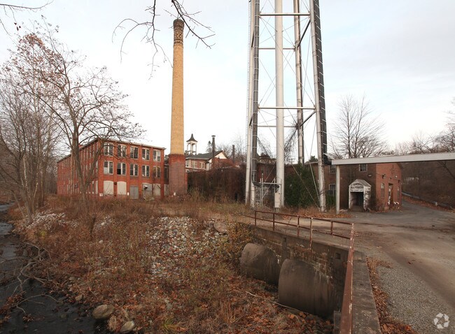
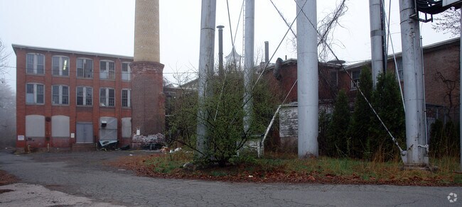
Property Record
47 Main St, Vernon Rockville, CT 06066

NEARBY LISTINGS FOR SALE OR LEASE
Property Detail
47 Main St
Hartford-West Hartford-East Hartford, CT
Tolland
VERN-000002-000158A-000003
Connecticut
Apartment
3
2024
7.60 AC
2025
Tolland County
530500
Hartford
DEMOGRAPHICS near 47 Main St
1 Mile
3 Mile
5 Mile
2024 Total Population
4,230
51,803
121,126
2029 Population
4,228
51,591
120,606
Pop Growth 2024-2029
(0.05%)
(0.41%)
(0.43%)
Average Age
45
42
41
2024 Total Households
1,903
21,794
51,196
HH Growth 2024-2029
(0.05%)
(0.44%)
(0.46%)
Median Household Inc
$70,499
$90,652
$82,023
Avg Household Size
2.20
2.30
2.30
2024 Avg HH Vehicles
2.00
2.00
2.00
Median Home Value
$246,774
$247,723
$246,907
Median Year Built
1968
1974
1968
Nearby Places
Map Layers
Map Styles
 Street
 Aerial
- Restaurants
- Banks
- Shops
- Fitness
- Groceries
PUBLIC TRANSPORTATION
AIRPORT
Bradley International
DRIVE
WALK
Distance
Bradley International
38 min
19.2 mi
Freight Ports
Port of New Haven
DRIVE
WALK
Distance
Port of New Haven
63 min
48.2 mi
Nearby Properties
Address
Land Use
TOTAL SIZE
Lot Size
Zoning
Address
Land Use
TOTAL SIZE
Lot Size
Zoning
75.65 AC
PDZ GE
Address
Land Use
TOTAL SIZE
Lot Size
Zoning
467,349 SF
13.83 AC
CUD
Address
Land Use
TOTAL SIZE
Lot Size
Zoning
29.87 AC
PDZ GE
Address
Land Use
TOTAL SIZE
Lot Size
Zoning
63.72 AC
R-22
Address
Land Use
TOTAL SIZE
Lot Size
Zoning
20,384 SF
40 AC
PRD
Address
Land Use
TOTAL SIZE
Lot Size
Zoning
28,608 SF
25.37 AC
CUD
Address
Land Use
TOTAL SIZE
Lot Size
Zoning
43.60 AC
PRD
Address
Land Use
TOTAL SIZE
Lot Size
Zoning
12,068 SF
21.79 AC
CUD
Address
Land Use
TOTAL SIZE
Lot Size
Zoning
29,744 SF
29.50 AC
PRD
Address
Land Use
TOTAL SIZE
Lot Size
Zoning
24.02 AC
COMMER
Address
Land Use
TOTAL SIZE
Lot Size
Zoning
53.59 AC
RA
Address
Land Use
TOTAL SIZE
Lot Size
Zoning
188,775 SF
74.13 AC
R-27
Address
Land Use
TOTAL SIZE
Lot Size
Zoning
149,322 SF
16.76 AC
A30
Address
Land Use
TOTAL SIZE
Lot Size
Zoning
111,800 SF
5.80 AC
GD
Address
Land Use
TOTAL SIZE
Lot Size
Zoning
156,929 SF
43 AC
GD
Address
Land Use
TOTAL SIZE
Lot Size
Zoning
68,988 SF
9.17 AC
GB
Address
Land Use
TOTAL SIZE
Lot Size
Zoning
43,394 SF
35 AC
A30
Address
Land Use
TOTAL SIZE
Lot Size
Zoning
11 AC
R-27
Address
Land Use
TOTAL SIZE
Lot Size
Zoning
27.05 AC
COMMER
Address
Land Use
TOTAL SIZE
Lot Size
Zoning
81,412 SF
9.20 AC
GD
Address
Land Use
TOTAL SIZE
Lot Size
Zoning
127,089 SF
12.89 AC
GD
Address
Land Use
TOTAL SIZE
Lot Size
Zoning
7.11 AC
CUD
Address
Land Use
TOTAL SIZE
Lot Size
Zoning
106,380 SF
12.55 AC
CUD
Address
Land Use
TOTAL SIZE
Lot Size
Zoning
144,679 SF
16.39 AC
CUD
Address
Land Use
TOTAL SIZE
Lot Size
Zoning
69,939 SF
4.62 AC
GD
Address
Land Use
TOTAL SIZE
Lot Size
Zoning
16 AC
RA
Address
Land Use
TOTAL SIZE
Lot Size
Zoning
19.72 AC
GB
Address
Land Use
TOTAL SIZE
Lot Size
Zoning
16.18 AC
COMMER
Address
Land Use
TOTAL SIZE
Lot Size
Zoning
3,200 SF
9.09 AC
COMMER
Address
Land Use
TOTAL SIZE
Lot Size
Zoning
129,695 SF
14.11 AC
GD
The World's #1 Commercial Real Estate Marketplace
Connect with us
© 2026 CoStar Group
The information above has been obtained from sources believed reliable. While we do not doubt its accuracy we have not verified it and make no guarantee, warranty or representation about it. It is your responsibility to independently confirm its accuracy and completeness. Any projections, opinions, assumptions, or estimates used are for example only and do not represent the current or future performance of the property. The value of this transaction to you depends on tax and other factors which should be evaluated by your tax, financial, and legal advisors. You and your advisors should conduct a careful, independent investigation of the property to determine to your satisfaction the suitability of the property for your needs.