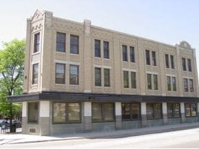
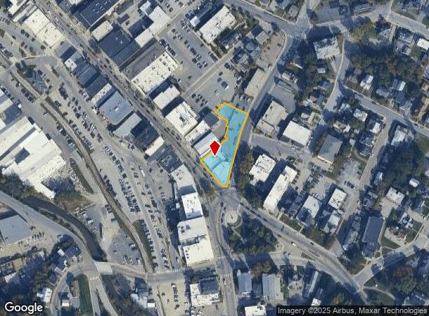
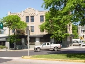
Property Record
47 N Main St, Barre, VT 05641
NEARBY LISTINGS FOR SALE OR LEASE
Property Detail
47 N Main St
036-011-12186
RESTAURANT/OFFICES/2 APTS/RETAIL-0.59AC
Commercialofficeresidentialmixeduse
Washington
AE
Vermont
50023C0434E
0.59 AC
2023
Vermont North Area
2024
Other Market Areas
955100
Barre, VT
10,527 SF
DEMOGRAPHICS near 47 N Main St
1 Mile
3 Mile
5 Mile
2024 Total Population
8,738
14,717
21,426
2029 Population
8,822
14,778
21,494
Pop Growth 2024-2029
+ 0.96%
+ 0.41%
+ 0.32%
Average Age
42
43
43
2024 Total Households
4,065
6,539
9,361
HH Growth 2024-2029
+ 0.93%
+ 0.40%
+ 0.31%
Median Household Inc
$54,371
$64,012
$68,384
Avg Household Size
2.00
2.10
2.20
2024 Avg HH Vehicles
1.00
2.00
2.00
Median Home Value
$167,517
$194,906
$210,718
Median Year Built
1951
1965
1969
Nearby Places
Map Layers
Map Styles
 Street
 Aerial
- Restaurants
- Banks
- Shops
- Fitness
- Groceries
PUBLIC TRANSPORTATION
COMMUTER RAIL
DRIVE
WALK
Distance
14 min
8.6 mi
AIRPORT
Patrick Leahy Burlington International
DRIVE
WALK
Distance
Patrick Leahy Burlington International
63 min
43.5 mi
Nearby Properties
Address
Land Use
TOTAL SIZE
Lot Size
Zoning
Address
Land Use
TOTAL SIZE
Lot Size
Zoning
7,500 SF
21.47 AC
A
Address
Land Use
TOTAL SIZE
Lot Size
Zoning
0.58 AC
AE
Address
Land Use
TOTAL SIZE
Lot Size
Zoning
3,084 SF
20 AC
HDR
Address
Land Use
TOTAL SIZE
Lot Size
Zoning
Address
Land Use
TOTAL SIZE
Lot Size
Zoning
Address
Land Use
TOTAL SIZE
Lot Size
Zoning
242.35 AC
Address
Land Use
TOTAL SIZE
Lot Size
Zoning
11.40 AC
CIV
Address
Land Use
TOTAL SIZE
Lot Size
Zoning
Address
Land Use
TOTAL SIZE
Lot Size
Zoning
54,324 SF
2.76 AC
MU-1
Address
Land Use
TOTAL SIZE
Lot Size
Zoning
27,913 SF
10.45 AC
CIV
Address
Land Use
TOTAL SIZE
Lot Size
Zoning
43,014 SF
1.01 AC
UC-1
Address
Land Use
TOTAL SIZE
Lot Size
Zoning
3.40 AC
UC-2
Address
Land Use
TOTAL SIZE
Lot Size
Zoning
130,680 SF
0.76 AC
UC-1
Address
Land Use
TOTAL SIZE
Lot Size
Zoning
21,600 SF
7.70 AC
I
Address
Land Use
TOTAL SIZE
Lot Size
Zoning
103,980 SF
0.95 AC
AE
Address
Land Use
TOTAL SIZE
Lot Size
Zoning
62,930 SF
0.62 AC
UC-2
Address
Land Use
TOTAL SIZE
Lot Size
Zoning
30,338 SF
6.10 AC
HC
Address
Land Use
TOTAL SIZE
Lot Size
Zoning
28,780 SF
4.08 AC
AE
Address
Land Use
TOTAL SIZE
Lot Size
Zoning
39,183 SF
1.50 AC
UC-2
Address
Land Use
TOTAL SIZE
Lot Size
Zoning
26,093 SF
6.90 AC
R-4
Address
Land Use
TOTAL SIZE
Lot Size
Zoning
126,256 SF
31.48 AC
Address
Land Use
TOTAL SIZE
Lot Size
Zoning
11.55 AC
AE
Address
Land Use
TOTAL SIZE
Lot Size
Zoning
10.30 AC
R-4
Address
Land Use
TOTAL SIZE
Lot Size
Zoning
36,809 SF
5.20 AC
HC
Address
Land Use
TOTAL SIZE
Lot Size
Zoning
31,671 SF
0.29 AC
AE
Address
Land Use
TOTAL SIZE
Lot Size
Zoning
34,700 SF
0.37 AC
UC-2
Address
Land Use
TOTAL SIZE
Lot Size
Zoning
6,175 SF
1.50 AC
AE
Address
Land Use
TOTAL SIZE
Lot Size
Zoning
13.70 AC
R-4
Address
Land Use
TOTAL SIZE
Lot Size
Zoning
10.60 AC
Address
Land Use
TOTAL SIZE
Lot Size
Zoning
57,600 SF
10 AC
I
The World's #1 Commercial Real Estate Marketplace
Connect with us
© 2026 CoStar Group
The information above has been obtained from sources believed reliable. While we do not doubt its accuracy we have not verified it and make no guarantee, warranty or representation about it. It is your responsibility to independently confirm its accuracy and completeness. Any projections, opinions, assumptions, or estimates used are for example only and do not represent the current or future performance of the property. The value of this transaction to you depends on tax and other factors which should be evaluated by your tax, financial, and legal advisors. You and your advisors should conduct a careful, independent investigation of the property to determine to your satisfaction the suitability of the property for your needs.