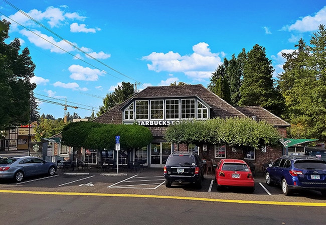
Property Record
47 N State St, Lake Oswego, OR 97034

NEARBY LISTINGS FOR SALE OR LEASE
Property Detail
47 N State St
Portland-Vancouver-Hillsboro, OR-WA
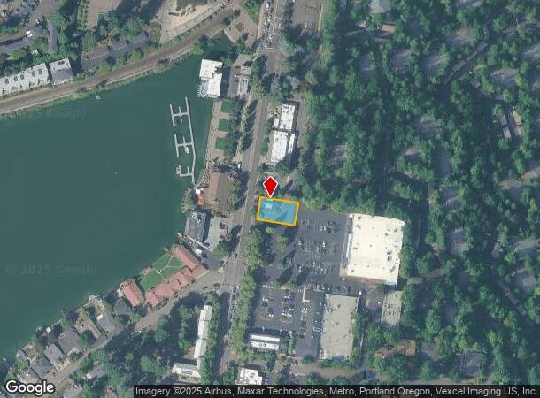
Map Of Oswego
00253692
SECTION 10 TOWNSHIP 2S RANGE 1E QUARTER AA TAX LOT 04001
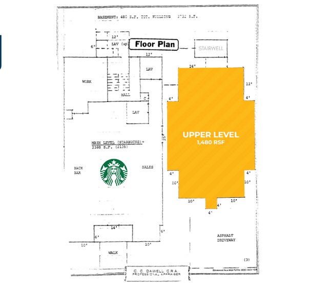
Commercialbuilding
Clackamas
X
Oregon
41067C0575E
4001
2025
0.19 AC
2025
Lake Oswego/West Linn
020201
Portland
1 SF
DEMOGRAPHICS near 47 N State St
1 Mile
3 Mile
5 Mile
2024 Total Population
11,264
83,532
262,911
2029 Population
11,609
85,625
265,772
Pop Growth 2024-2029
+ 3.06%
+ 2.51%
+ 1.09%
Average Age
46
45
42
2024 Total Households
4,896
34,459
107,175
HH Growth 2024-2029
+ 3.08%
+ 2.57%
+ 1.01%
Median Household Inc
$118,600
$101,528
$97,052
Avg Household Size
2.30
2.30
2.40
2024 Avg HH Vehicles
2.00
2.00
2.00
Median Home Value
$871,987
$691,631
$611,740
Median Year Built
1973
1976
1976
Nearby Places
Map Layers
Map Styles
 Street
 Aerial
- Restaurants
- Banks
- Shops
- Fitness
- Groceries
PUBLIC TRANSPORTATION
COMMUTER RAIL
Oregon City Amtrak (Amtrak Cascades - Amtrak)
DRIVE
WALK
Distance
Oregon City Amtrak (Amtrak Cascades - Amtrak)
15 min
6.4 mi
Tigard Transit Center (Westside Express Service - Tri-County Metropolitan Transportation District of Oregon Rail (TriMet Rail))
DRIVE
WALK
Distance
Tigard Transit Center (Westside Express Service - Tri-County Metropolitan Transportation District of Oregon Rail (TriMet Rail))
16 min
6.8 mi
AIRPORT
Portland International
DRIVE
WALK
Distance
Portland International
34 min
20.0 mi
Freight Ports
Port of Portland
DRIVE
WALK
Distance
Port of Portland
20 min
11.2 mi
SALE & LEASE HISTORY
LISTING DATE
SALE/LEASE

May 01, 2023
For Lease
Jan 06, 2017
For Lease
Nearby Properties
Address
Land Use
TOTAL SIZE
Lot Size
Zoning
Address
Land Use
TOTAL SIZE
Lot Size
Zoning
931,749 SF
85.50 AC
CI1
Address
Land Use
TOTAL SIZE
Lot Size
Zoning
Address
Land Use
TOTAL SIZE
Lot Size
Zoning
138,295 SF
29.79 AC
CI1
Address
Land Use
TOTAL SIZE
Lot Size
Zoning
28.30 AC
EC/R-0
Address
Land Use
TOTAL SIZE
Lot Size
Zoning
6.48 AC
R-3
Address
Land Use
TOTAL SIZE
Lot Size
Zoning
Address
Land Use
TOTAL SIZE
Lot Size
Zoning
1 SF
1 AC
PF
Address
Land Use
TOTAL SIZE
Lot Size
Zoning
3,550 SF
3.99 AC
DMU
Address
Land Use
TOTAL SIZE
Lot Size
Zoning
5,724 SF
13.95 AC
NC/R-0
Address
Land Use
TOTAL SIZE
Lot Size
Zoning
1 SF
0.14 AC
EC
Address
Land Use
TOTAL SIZE
Lot Size
Zoning
10.35 AC
PF
Address
Land Use
TOTAL SIZE
Lot Size
Zoning
0.26 AC
C3
Address
Land Use
TOTAL SIZE
Lot Size
Zoning
21.39 AC
CI
Address
Land Use
TOTAL SIZE
Lot Size
Zoning
11.35 AC
C3
Address
Land Use
TOTAL SIZE
Lot Size
Zoning
62,048 SF
8.58 AC
R20
Address
Land Use
TOTAL SIZE
Lot Size
Zoning
35.26 AC
PNA
Address
Land Use
TOTAL SIZE
Lot Size
Zoning
11.10 AC
HDR
Address
Land Use
TOTAL SIZE
Lot Size
Zoning
1.61 AC
DMU
Address
Land Use
TOTAL SIZE
Lot Size
Zoning
1 SF
4.73 AC
R-3
Address
Land Use
TOTAL SIZE
Lot Size
Zoning
7 AC
NME
Address
Land Use
TOTAL SIZE
Lot Size
Zoning
22.01 AC
BI
Address
Land Use
TOTAL SIZE
Lot Size
Zoning
6 AC
R-0
Address
Land Use
TOTAL SIZE
Lot Size
Zoning
122,430 SF
10.85 AC
NC
Address
Land Use
TOTAL SIZE
Lot Size
Zoning
3.45 AC
R-15
Address
Land Use
TOTAL SIZE
Lot Size
Zoning
1 SF
11.53 AC
OC/R-3
Address
Land Use
TOTAL SIZE
Lot Size
Zoning
Address
Land Use
TOTAL SIZE
Lot Size
Zoning
121,443 SF
6.58 AC
NC/R-0
Address
Land Use
TOTAL SIZE
Lot Size
Zoning
6 AC
HDR
Address
Land Use
TOTAL SIZE
Lot Size
Zoning
9.67 AC
C3
Address
Land Use
TOTAL SIZE
Lot Size
Zoning
1.43 AC
C3
The World's #1 Commercial Real Estate Marketplace
Connect with us
© 2026 CoStar Group
The information above has been obtained from sources believed reliable. While we do not doubt its accuracy we have not verified it and make no guarantee, warranty or representation about it. It is your responsibility to independently confirm its accuracy and completeness. Any projections, opinions, assumptions, or estimates used are for example only and do not represent the current or future performance of the property. The value of this transaction to you depends on tax and other factors which should be evaluated by your tax, financial, and legal advisors. You and your advisors should conduct a careful, independent investigation of the property to determine to your satisfaction the suitability of the property for your needs.