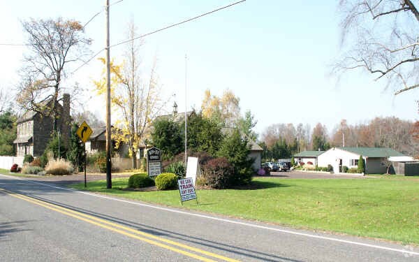
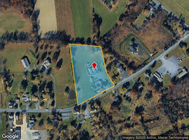
Property Record
47 Ridge Rd, Telford, PA 18969
NEARBY LISTINGS FOR SALE OR LEASE
-
-
View all Telford listings for sale on LoopNet.com
Property Detail
47 Ridge Rd
44-00-01639-009
ASSESSOR BLOCK-UNIT NUMBER 4-22
Commercialnec
Montgomery
X
Pennsylvania
42091C0107G
22
2024
3.69 AC
2025
West Montgomery County
207103
Philadelphia
6,842 SF
Philadelphia-Camden-Wilmington, PA-NJ-DE-MD
DEMOGRAPHICS near 47 Ridge Rd
1 Mile
3 Mile
5 Mile
2024 Total Population
1,192
12,420
65,047
2029 Population
1,181
12,389
65,334
Pop Growth 2024-2029
(0.92%)
(0.25%)
+ 0.44%
Average Age
42
43
43
2024 Total Households
437
4,683
24,926
HH Growth 2024-2029
(0.92%)
(0.36%)
+ 0.37%
Median Household Inc
$111,775
$105,727
$95,459
Avg Household Size
2.70
2.60
2.50
2024 Avg HH Vehicles
2.00
2.00
2.00
Median Home Value
$414,557
$365,770
$342,247
Median Year Built
1976
1975
1977
Nearby Places
Map Layers
Map Styles
 Street
 Aerial
- Restaurants
- Banks
- Shops
- Fitness
- Groceries
PUBLIC TRANSPORTATION
COMMUTER RAIL
Colmar (R5 - Southeastern Pennsylvania Transportation Authority Regional Rail (SEPTA Regional Rail))
DRIVE
WALK
Distance
Colmar (R5 - Southeastern Pennsylvania Transportation Authority Regional Rail (SEPTA Regional Rail))
18 min
9.3 mi
AIRPORT
Lehigh Valley International
DRIVE
WALK
Distance
Lehigh Valley International
44 min
31.2 mi
Freight Ports
Port of Philadelphia
DRIVE
WALK
Distance
Port of Philadelphia
55 min
39.5 mi
Nearby Properties
Address
Land Use
TOTAL SIZE
Lot Size
Zoning
Address
Land Use
TOTAL SIZE
Lot Size
Zoning
412,306 SF
40.91 AC
I
Address
Land Use
TOTAL SIZE
Lot Size
Zoning
77,878 SF
17.60 AC
INST
Address
Land Use
TOTAL SIZE
Lot Size
Zoning
30,267 SF
149.18 AC
REC
Address
Land Use
TOTAL SIZE
Lot Size
Zoning
39,066 SF
24.21 AC
REC
Address
Land Use
TOTAL SIZE
Lot Size
Zoning
125,845 SF
11.85 AC
LI
Address
Land Use
TOTAL SIZE
Lot Size
Zoning
27,623 SF
4.44 AC
A
Address
Land Use
TOTAL SIZE
Lot Size
Zoning
24,794 SF
346.93 AC
R1
Address
Land Use
TOTAL SIZE
Lot Size
Zoning
39,874 SF
11.52 AC
R100
Address
Land Use
TOTAL SIZE
Lot Size
Zoning
25,354 SF
13.62 AC
INST
Address
Land Use
TOTAL SIZE
Lot Size
Zoning
80,544 SF
5.30 AC
LI
Address
Land Use
TOTAL SIZE
Lot Size
Zoning
29,049 SF
17.69 AC
R130
Address
Land Use
TOTAL SIZE
Lot Size
Zoning
53,148 SF
2.93 AC
B
Address
Land Use
TOTAL SIZE
Lot Size
Zoning
34,168 SF
4.50 AC
R100
Address
Land Use
TOTAL SIZE
Lot Size
Zoning
18,687 SF
20.51 AC
RR
Address
Land Use
TOTAL SIZE
Lot Size
Zoning
7,970 SF
5.26 AC
C
Address
Land Use
TOTAL SIZE
Lot Size
Zoning
29,166 SF
2.18 AC
LI
Address
Land Use
TOTAL SIZE
Lot Size
Zoning
27,500 SF
2.37 AC
LI
Address
Land Use
TOTAL SIZE
Lot Size
Zoning
29.01 AC
REC
Address
Land Use
TOTAL SIZE
Lot Size
Zoning
24,612 SF
2.34 AC
LI
Address
Land Use
TOTAL SIZE
Lot Size
Zoning
10,465 SF
1.79 AC
C
Address
Land Use
TOTAL SIZE
Lot Size
Zoning
213,419 SF
33.19 AC
PI
Address
Land Use
TOTAL SIZE
Lot Size
Zoning
31,139 SF
12.86 AC
VC
Address
Land Use
TOTAL SIZE
Lot Size
Zoning
5,416 SF
14.24 AC
RR
Address
Land Use
TOTAL SIZE
Lot Size
Zoning
13,250 SF
2.41 AC
LI
Address
Land Use
TOTAL SIZE
Lot Size
Zoning
18,060 SF
2.37 AC
B
Address
Land Use
TOTAL SIZE
Lot Size
Zoning
28,379 SF
11.91 AC
VCR
Address
Land Use
TOTAL SIZE
Lot Size
Zoning
9,376 SF
13.66 AC
R60
Address
Land Use
TOTAL SIZE
Lot Size
Zoning
66,214 SF
22.92 AC
PC
Address
Land Use
TOTAL SIZE
Lot Size
Zoning
25,981 SF
3.40 AC
VC
Address
Land Use
TOTAL SIZE
Lot Size
Zoning
18,780 SF
2.45 AC
LI
The World's #1 Commercial Real Estate Marketplace
Connect with us
© 2026 CoStar Group
The information above has been obtained from sources believed reliable. While we do not doubt its accuracy we have not verified it and make no guarantee, warranty or representation about it. It is your responsibility to independently confirm its accuracy and completeness. Any projections, opinions, assumptions, or estimates used are for example only and do not represent the current or future performance of the property. The value of this transaction to you depends on tax and other factors which should be evaluated by your tax, financial, and legal advisors. You and your advisors should conduct a careful, independent investigation of the property to determine to your satisfaction the suitability of the property for your needs.