Property Record
47 River Rd, Preston, CT 06365

Property Detail
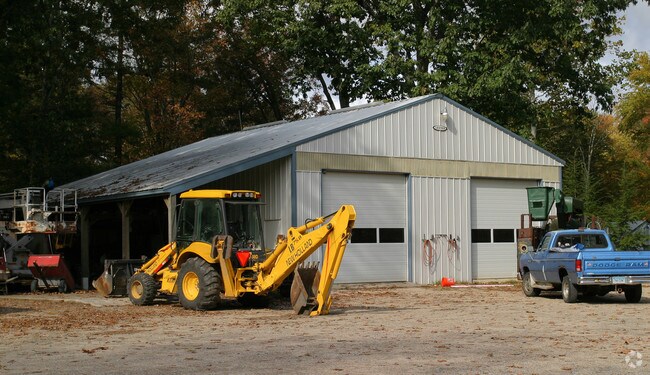
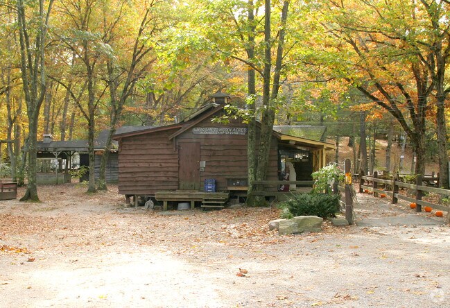
47 River Rd
PRES-000060-R000001IV000047
Southeastern Ct
Commercialnec
Connecticut
R-60
47
A Areas with a 1% annual chance of flooding and a 26% chance of flooding over the life of a 30-year mortgage.
60 AC
2024
NE New London/Norwich
2025
Hartford
700100
Norwich-New London-Willimantic, CT
NEARBY LISTINGS FOR SALE OR LEASE
-
-
View all Preston listings for sale on LoopNet.com
DEMOGRAPHICS near 47 River Rd
1 mile
3 mile
5 mile
2025 Total Population
625
14,178
46,223
2030 Population
621
14,286
46,578
Pop Growth 2025-2030
(0.64%)
+ 0.76%
+ 0.77%
Average Age
46
41
41
2025 Total Households
264
5,962
19,039
HH Growth 2025-2030
(0.76%)
+ 0.75%
+ 0.72%
Median Household Inc
$93,395
$65,481
$69,336
Avg Household Size
2.40
2.30
2.30
2025 Avg HH Vehicles
3.00
2.00
2.00
Median Home Value
$350,000
$271,447
$269,122
Median Year Built
1969
1961
1956
Nearby Places
Map Layers
Map Styles
 Street
 Aerial
Layers
 Traffic
 Biking
Places
Listings with unknown addresses are not visible on the map
- Restaurants
- Banks
- Shops
- Fitness
- Groceries
Nearby Properties
Address
Land Use
TOTAL SIZE
Lot Size
Zoning
Address
Land Use
TOTAL SIZE
Lot Size
Zoning
21.33 AC
C4
Address
Land Use
TOTAL SIZE
Lot Size
Zoning
54.97 AC
GC
Address
Land Use
TOTAL SIZE
Lot Size
Zoning
182,533 SF
21.53 AC
C4
Address
Land Use
TOTAL SIZE
Lot Size
Zoning
1,500 SF
31.62 AC
600
Address
Land Use
TOTAL SIZE
Lot Size
Zoning
137,895 SF
11.28 AC
C4
Address
Land Use
TOTAL SIZE
Lot Size
Zoning
152,265 SF
131 SF
ID
Address
Land Use
TOTAL SIZE
Lot Size
Zoning
151,735 SF
131 SF
ID
Address
Land Use
TOTAL SIZE
Lot Size
Zoning
115,363 SF
16.51 AC
C4
Address
Land Use
TOTAL SIZE
Lot Size
Zoning
6.39 AC
MF
Address
Land Use
TOTAL SIZE
Lot Size
Zoning
138,642 SF
9.94 AC
C4
Address
Land Use
TOTAL SIZE
Lot Size
Zoning
70,639 SF
14 AC
R-80
Address
Land Use
TOTAL SIZE
Lot Size
Zoning
10 AC
R60
Address
Land Use
TOTAL SIZE
Lot Size
Zoning
83,453 SF
5.80 AC
MF
Address
Land Use
TOTAL SIZE
Lot Size
Zoning
78,364 SF
4.88 AC
GC
Address
Land Use
TOTAL SIZE
Lot Size
Zoning
34,004 SF
16.32 AC
C4
Address
Land Use
TOTAL SIZE
Lot Size
Zoning
3.28 AC
R20
Address
Land Use
TOTAL SIZE
Lot Size
Zoning
3,980 SF
28.50 AC
MF
Address
Land Use
TOTAL SIZE
Lot Size
Zoning
85,044 SF
Address
Land Use
TOTAL SIZE
Lot Size
Zoning
6.65 AC
MF
Address
Land Use
TOTAL SIZE
Lot Size
Zoning
6.60 AC
MF
Address
Land Use
TOTAL SIZE
Lot Size
Zoning
Address
Land Use
TOTAL SIZE
Lot Size
Zoning
43,142 SF
7.33 AC
MF
Address
Land Use
TOTAL SIZE
Lot Size
Zoning
5,952 SF
15.08 AC
MF
Address
Land Use
TOTAL SIZE
Lot Size
Zoning
9.38 AC
MF
Address
Land Use
TOTAL SIZE
Lot Size
Zoning
41,244 SF
MF
Address
Land Use
TOTAL SIZE
Lot Size
Zoning
36 AC
R40
Address
Land Use
TOTAL SIZE
Lot Size
Zoning
30,520 SF
8.66 AC
NC
Address
Land Use
TOTAL SIZE
Lot Size
Zoning
6 AC
GC
Address
Land Use
TOTAL SIZE
Lot Size
Zoning
3.12 AC
MF
Address
Land Use
TOTAL SIZE
Lot Size
Zoning
31,306 SF
MF
The World's #1 Commercial Real Estate Marketplace
Connect with us
© 2026 CoStar Group
The information above has been obtained from sources believed reliable. While we do not doubt its accuracy we have not verified it and make no guarantee, warranty or representation about it. It is your responsibility to independently confirm its accuracy and completeness. Any projections, opinions, assumptions, or estimates used are for example only and do not represent the current or future performance of the property. The value of this transaction to you depends on tax and other factors which should be evaluated by your tax, financial, and legal advisors. You and your advisors should conduct a careful, independent investigation of the property to determine to your satisfaction the suitability of the property for your needs.