Property Record
470 Henly Loop, Dripping Springs, TX 78620

Save to a Folder
{{folder.Name}}
{{folder.ListingIds.length}} Properties
{{folder.ListingIds.length}} Property
Create a New Folder
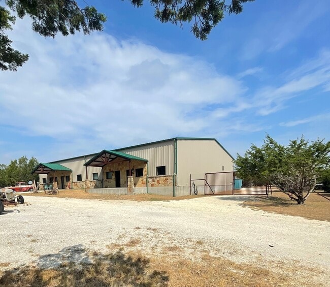
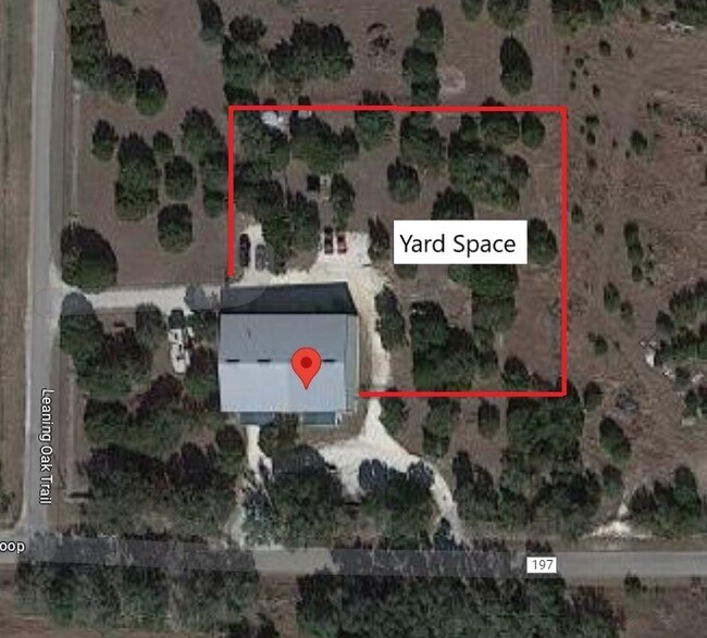
Property Detail
470 Henly Loop
Austin-Round Rock-San Marcos, TX
S5978 - OAK TREE ESTATES, LOT 1, ACRES 4.83
R118706
HAYS
Commercialnec
Texas
B and X Area of moderate flood hazard, usually the area between the limits of the 100-year and 500-year floods.
1
2024
4.83 AC
2025
Hays County
010817
Austin
7,500 SF
NEARBY LISTINGS FOR SALE OR LEASE
DEMOGRAPHICS near 470 Henly Loop
1 mile
3 mile
5 mile
2025 Total Population
406
1,351
2,762
2030 Population
469
1,554
3,182
Pop Growth 2025-2030
+ 15.52%
+ 15.03%
+ 15.21%
Average Age
43
44
45
2025 Total Households
154
523
1,076
HH Growth 2025-2030
+ 16.88%
+ 16.25%
+ 16.08%
Median Household Inc
$115,624
$128,860
$133,251
Avg Household Size
2.60
2.60
2.50
2025 Avg HH Vehicles
2.00
2.00
2.00
Median Home Value
$815,217
$827,380
$832,125
Median Year Built
2003
2000
2000
Nearby Places
Map Layers
Map Styles
 Street
 Aerial
Layers
 Traffic
 Biking
Places
Listings with unknown addresses are not visible on the map
- Restaurants
- Banks
- Shops
- Fitness
- Groceries
SALE & LEASE HISTORY
LISTING DATE
SALE/LEASE

Mar 11, 2019
For Lease
Nearby Properties
Address
Land Use
TOTAL SIZE
Lot Size
Zoning
Address
Land Use
TOTAL SIZE
Lot Size
Zoning
888 SF
5.93 AC
Address
Land Use
TOTAL SIZE
Lot Size
Zoning
3,000 SF
10.40 AC
Address
Land Use
TOTAL SIZE
Lot Size
Zoning
5,615 SF
3 AC
Address
Land Use
TOTAL SIZE
Lot Size
Zoning
7,760 SF
3.14 AC
Address
Land Use
TOTAL SIZE
Lot Size
Zoning
340 SF
27.33 AC
Address
Land Use
TOTAL SIZE
Lot Size
Zoning
344,392 SF
18.21 AC
Address
Land Use
TOTAL SIZE
Lot Size
Zoning
19,069 SF
104.04 AC
Address
Land Use
TOTAL SIZE
Lot Size
Zoning
Address
Land Use
TOTAL SIZE
Lot Size
Zoning
10,316 SF
10.65 AC
Address
Land Use
TOTAL SIZE
Lot Size
Zoning
5,000 SF
28.01 AC
Address
Land Use
TOTAL SIZE
Lot Size
Zoning
2,262 SF
7.47 AC
Address
Land Use
TOTAL SIZE
Lot Size
Zoning
4,630 SF
3.50 AC
Address
Land Use
TOTAL SIZE
Lot Size
Zoning
6,456 SF
7.36 AC
Address
Land Use
TOTAL SIZE
Lot Size
Zoning
6,160 SF
28.03 AC
Address
Land Use
TOTAL SIZE
Lot Size
Zoning
4,378 SF
34.77 AC
Address
Land Use
TOTAL SIZE
Lot Size
Zoning
11.45 AC
Address
Land Use
TOTAL SIZE
Lot Size
Zoning
3,200 SF
11.50 AC
Address
Land Use
TOTAL SIZE
Lot Size
Zoning
5,384 SF
56.60 AC
Address
Land Use
TOTAL SIZE
Lot Size
Zoning
9,000 SF
1.29 AC
Address
Land Use
TOTAL SIZE
Lot Size
Zoning
5,387 SF
11.82 AC
Address
Land Use
TOTAL SIZE
Lot Size
Zoning
4,506 SF
25.08 AC
Address
Land Use
TOTAL SIZE
Lot Size
Zoning
2,788 SF
6.89 AC
Address
Land Use
TOTAL SIZE
Lot Size
Zoning
5,129 SF
21 AC
Address
Land Use
TOTAL SIZE
Lot Size
Zoning
5,072 SF
24.67 AC
Address
Land Use
TOTAL SIZE
Lot Size
Zoning
Address
Land Use
TOTAL SIZE
Lot Size
Zoning
4,139 SF
40 AC
Address
Land Use
TOTAL SIZE
Lot Size
Zoning
3,490 SF
8.95 AC
Address
Land Use
TOTAL SIZE
Lot Size
Zoning
3,532 SF
19.28 AC
Address
Land Use
TOTAL SIZE
Lot Size
Zoning
1,218 SF
28.07 AC
Address
Land Use
TOTAL SIZE
Lot Size
Zoning
4,692 SF
3.47 AC
The World's #1 Commercial Real Estate Marketplace
Connect with us
© 2026 CoStar Group
The information above has been obtained from sources believed reliable. While we do not doubt its accuracy we have not verified it and make no guarantee, warranty or representation about it. It is your responsibility to independently confirm its accuracy and completeness. Any projections, opinions, assumptions, or estimates used are for example only and do not represent the current or future performance of the property. The value of this transaction to you depends on tax and other factors which should be evaluated by your tax, financial, and legal advisors. You and your advisors should conduct a careful, independent investigation of the property to determine to your satisfaction the suitability of the property for your needs.