Property Record
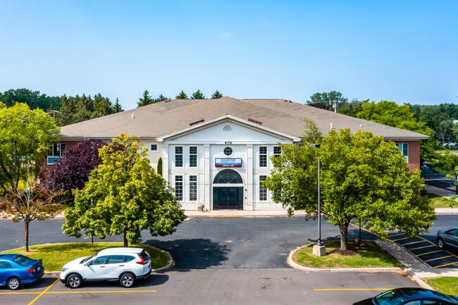
470 Long Pond Rd, Rochester, NY 14612


NEARBY LISTINGS FOR SALE OR LEASE
Property Detail
470 Long Pond Rd
Rochester, NY
Resubdivision Of Lands Of Long Pond Prof
262800-045-010-0001-006-101
1ST DIV L34 T2 LONG POND PROF CTR 300-84 L 1
Professionalbldglegalinsurancerealestateetc
Monroe
X
New York
36055C0064H
6.101
2025
2.58 AC
2024
Northwest
013603
Rochester
25,000 SF
DEMOGRAPHICS near 470 Long Pond Rd
1 Mile
3 Mile
5 Mile
2024 Total Population
6,953
42,711
109,231
2029 Population
6,850
42,269
107,688
Pop Growth 2024-2029
(1.48%)
(1.03%)
(1.41%)
Average Age
45
44
43
2024 Total Households
2,669
17,551
47,128
HH Growth 2024-2029
(1.61%)
(1.11%)
(1.48%)
Median Household Inc
$100,316
$79,391
$67,418
Avg Household Size
2.50
2.40
2.30
2024 Avg HH Vehicles
2.00
2.00
2.00
Median Home Value
$180,909
$182,203
$159,173
Median Year Built
1984
1979
1970
Nearby Places
Map Layers
Map Styles
 Street
 Aerial
- Restaurants
- Banks
- Shops
- Fitness
- Groceries
PUBLIC TRANSPORTATION
AIRPORT
Frederick Douglass/Greater Rochester International
DRIVE
WALK
Distance
Frederick Douglass/Greater Rochester International
20 min
13.3 mi
SALE & LEASE HISTORY
LISTING DATE
SALE/LEASE

Oct 09, 2019
For Sale
Mar 03, 2020
For Sale
Jul 26, 2018
For Sale
Jul 25, 2023
For Sale
Feb 25, 2022
For Sale
Feb 22, 2017
For Sale
Aug 15, 2017
For Lease
Aug 15, 2017
For Sale
Apr 30, 2024
For Sale
Apr 10, 2018
For Lease
Nearby Properties
Address
Land Use
TOTAL SIZE
Lot Size
Zoning
Address
Land Use
TOTAL SIZE
Lot Size
Zoning
1,763.70 AC
Address
Land Use
TOTAL SIZE
Lot Size
Zoning
352,001 SF
76.90 AC
Address
Land Use
TOTAL SIZE
Lot Size
Zoning
330,700 SF
66.90 AC
Address
Land Use
TOTAL SIZE
Lot Size
Zoning
180,406 SF
28.80 AC
Address
Land Use
TOTAL SIZE
Lot Size
Zoning
65,000 SF
5.10 AC
Address
Land Use
TOTAL SIZE
Lot Size
Zoning
37,487 SF
47.63 AC
Address
Land Use
TOTAL SIZE
Lot Size
Zoning
4,728 SF
34.54 AC
03 - MULTI
Address
Land Use
TOTAL SIZE
Lot Size
Zoning
1.90 AC
05 - COMME
Address
Land Use
TOTAL SIZE
Lot Size
Zoning
9,360 SF
23.50 AC
05 - COMME
Address
Land Use
TOTAL SIZE
Lot Size
Zoning
0.84 AC
Address
Land Use
TOTAL SIZE
Lot Size
Zoning
108,401 SF
67.82 AC
05 - COMME
Address
Land Use
TOTAL SIZE
Lot Size
Zoning
7,120 SF
23.10 AC
Address
Land Use
TOTAL SIZE
Lot Size
Zoning
78,957 SF
90.80 AC
02 - SINGL
Address
Land Use
TOTAL SIZE
Lot Size
Zoning
14,080 SF
15.20 AC
05 - COMME
Address
Land Use
TOTAL SIZE
Lot Size
Zoning
2,572 SF
26.40 AC
Address
Land Use
TOTAL SIZE
Lot Size
Zoning
93,865 SF
62.80 AC
Address
Land Use
TOTAL SIZE
Lot Size
Zoning
76,739 SF
12.79 AC
Address
Land Use
TOTAL SIZE
Lot Size
Zoning
56,856 SF
15 AC
Address
Land Use
TOTAL SIZE
Lot Size
Zoning
3,472 SF
19.60 AC
05 - COMME
Address
Land Use
TOTAL SIZE
Lot Size
Zoning
5,758 SF
10.50 AC
Address
Land Use
TOTAL SIZE
Lot Size
Zoning
44,785 SF
8.20 AC
05 - COMME
Address
Land Use
TOTAL SIZE
Lot Size
Zoning
7,064 SF
9.90 AC
Address
Land Use
TOTAL SIZE
Lot Size
Zoning
7,064 SF
11.10 AC
Address
Land Use
TOTAL SIZE
Lot Size
Zoning
14.60 AC
Address
Land Use
TOTAL SIZE
Lot Size
Zoning
33,431 SF
9.60 AC
Address
Land Use
TOTAL SIZE
Lot Size
Zoning
13,233 SF
16.60 AC
Address
Land Use
TOTAL SIZE
Lot Size
Zoning
5,048 SF
11.30 AC
02 - SINGL
Address
Land Use
TOTAL SIZE
Lot Size
Zoning
97,168 SF
6.90 AC
Address
Land Use
TOTAL SIZE
Lot Size
Zoning
7,353 SF
12.50 AC
The World's #1 Commercial Real Estate Marketplace
Connect with us
© 2026 CoStar Group
The information above has been obtained from sources believed reliable. While we do not doubt its accuracy we have not verified it and make no guarantee, warranty or representation about it. It is your responsibility to independently confirm its accuracy and completeness. Any projections, opinions, assumptions, or estimates used are for example only and do not represent the current or future performance of the property. The value of this transaction to you depends on tax and other factors which should be evaluated by your tax, financial, and legal advisors. You and your advisors should conduct a careful, independent investigation of the property to determine to your satisfaction the suitability of the property for your needs.