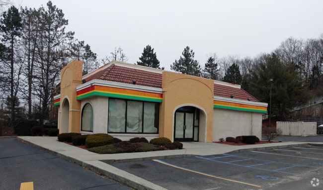
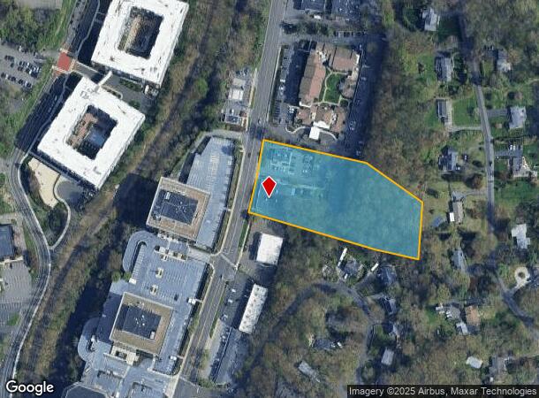
Property Record
470 Main Ave, Norwalk, CT 06851

NEARBY LISTINGS FOR SALE OR LEASE
Property Detail
470 Main Ave
NORW-000005-000022C-000004
Fairfield
Commercialnec
Connecticut
X
4
09001C0393G
3.35 AC
2025
Norwalk
2025
Westchester/So Connecticut
042700
Bridgeport-Stamford-Norwalk, CT
DEMOGRAPHICS near 470 Main Ave
1 Mile
3 Mile
5 Mile
2024 Total Population
6,405
61,876
143,898
2029 Population
6,455
61,905
144,034
Pop Growth 2024-2029
+ 0.78%
+ 0.05%
+ 0.09%
Average Age
41
41
40
2024 Total Households
2,899
24,049
53,868
HH Growth 2024-2029
+ 0.90%
+ 0.05%
+ 0.07%
Median Household Inc
$127,366
$113,908
$120,168
Avg Household Size
2.10
2.50
2.60
2024 Avg HH Vehicles
2.00
2.00
2.00
Median Home Value
$485,630
$548,811
$706,086
Median Year Built
1982
1968
1966
Nearby Places
Map Layers
Map Styles
 Street
 Aerial
- Restaurants
- Banks
- Shops
- Fitness
- Groceries
PUBLIC TRANSPORTATION
COMMUTER RAIL
Merritt 7 Station (New Haven Line - Metro-North Commuter Railroad Company (Metro-North))
DRIVE
WALK
Distance
Merritt 7 Station (New Haven Line - Metro-North Commuter Railroad Company (Metro-North))
1 min
8 min
0.4 mi
Wilton Station (New Haven Line - Metro-North Commuter Railroad Company (Metro-North))
DRIVE
WALK
Distance
Wilton Station (New Haven Line - Metro-North Commuter Railroad Company (Metro-North))
6 min
3.7 mi
AIRPORT
Westchester County
DRIVE
WALK
Distance
Westchester County
32 min
21.8 mi
Tweed/New Haven
DRIVE
WALK
Distance
Tweed/New Haven
55 min
36.8 mi
Freight Ports
Port of New Haven
DRIVE
WALK
Distance
Port of New Haven
50 min
34.0 mi
Nearby Properties
Address
Land Use
TOTAL SIZE
Lot Size
Zoning
Address
Land Use
TOTAL SIZE
Lot Size
Zoning
4.49 AC
CBDB
Address
Land Use
TOTAL SIZE
Lot Size
Zoning
749,988 SF
4.52 AC
CBDB
Address
Land Use
TOTAL SIZE
Lot Size
Zoning
339,272 SF
4.07 AC
EO
Address
Land Use
TOTAL SIZE
Lot Size
Zoning
6.80 AC
B2
Address
Land Use
TOTAL SIZE
Lot Size
Zoning
226,920 SF
24.75 AC
B
Address
Land Use
TOTAL SIZE
Lot Size
Zoning
28.64 AC
DE-10
Address
Land Use
TOTAL SIZE
Lot Size
Zoning
4.44 AC
CBDB
Address
Land Use
TOTAL SIZE
Lot Size
Zoning
248,486 SF
6.57 AC
EO
Address
Land Use
TOTAL SIZE
Lot Size
Zoning
292,852 SF
3.38 AC
EO
Address
Land Use
TOTAL SIZE
Lot Size
Zoning
254,126 SF
3.33 AC
EO
Address
Land Use
TOTAL SIZE
Lot Size
Zoning
320,588 SF
3.22 AC
EO
Address
Land Use
TOTAL SIZE
Lot Size
Zoning
254,126 SF
3.06 AC
EO
Address
Land Use
TOTAL SIZE
Lot Size
Zoning
252,316 SF
Address
Land Use
TOTAL SIZE
Lot Size
Zoning
271,344 SF
2.36 AC
EO
Address
Land Use
TOTAL SIZE
Lot Size
Zoning
196,084 SF
4.34 AC
DE-5
Address
Land Use
TOTAL SIZE
Lot Size
Zoning
21.34 AC
B2
Address
Land Use
TOTAL SIZE
Lot Size
Zoning
13.46 AC
RB
Address
Land Use
TOTAL SIZE
Lot Size
Zoning
24.67 AC
DE-10
Address
Land Use
TOTAL SIZE
Lot Size
Zoning
12.32 AC
CRA-1
Address
Land Use
TOTAL SIZE
Lot Size
Zoning
41.63 AC
A2
Address
Land Use
TOTAL SIZE
Lot Size
Zoning
29.26 AC
PRO
Address
Land Use
TOTAL SIZE
Lot Size
Zoning
175,791 SF
1.58 AC
CBDB
Address
Land Use
TOTAL SIZE
Lot Size
Zoning
34.16 AC
R-2
Address
Land Use
TOTAL SIZE
Lot Size
Zoning
165,384 SF
18.78 AC
B
Address
Land Use
TOTAL SIZE
Lot Size
Zoning
4.79 AC
EO
Address
Land Use
TOTAL SIZE
Lot Size
Zoning
248,782 SF
3.52 AC
EO
Address
Land Use
TOTAL SIZE
Lot Size
Zoning
10.64 AC
HODD
Address
Land Use
TOTAL SIZE
Lot Size
Zoning
74,233 SF
4.26 AC
A2
Address
Land Use
TOTAL SIZE
Lot Size
Zoning
249,779 SF
3.09 AC
EO
Address
Land Use
TOTAL SIZE
Lot Size
Zoning
214,890 SF
2.91 AC
EO
The World's #1 Commercial Real Estate Marketplace
Connect with us
© 2025 CoStar Group
The information above has been obtained from sources believed reliable. While we do not doubt its accuracy we have not verified it and make no guarantee, warranty or representation about it. It is your responsibility to independently confirm its accuracy and completeness. Any projections, opinions, assumptions, or estimates used are for example only and do not represent the current or future performance of the property. The value of this transaction to you depends on tax and other factors which should be evaluated by your tax, financial, and legal advisors. You and your advisors should conduct a careful, independent investigation of the property to determine to your satisfaction the suitability of the property for your needs.