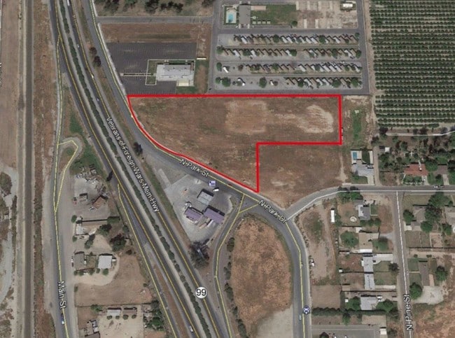
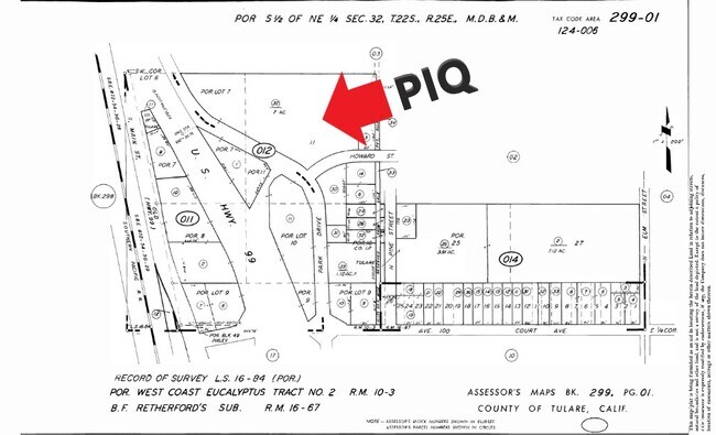
Property Record
470 N Park Dr, Pixley, CA 93256


NEARBY LISTINGS FOR SALE OR LEASE
Property Detail
470 N Park Dr
Visalia-Porterville, CA
Parcel Map No 5149
299-012-037-000
PARCEL 2, PARCEL MAP NO 5149, PM 52-56
Commercialnec
Tulare
A
California
06107C1925E
5.86 AC
2024
SW Outlying Tulare County
2025
Visalia/Porterville
004200
DEMOGRAPHICS near 470 N Park Dr
1 Mile
3 Mile
5 Mile
2024 Total Population
3,061
4,410
5,347
2029 Population
3,030
4,370
5,291
Pop Growth 2024-2029
(1.01%)
(0.91%)
(1.05%)
Average Age
31
32
32
2024 Total Households
787
1,121
1,356
HH Growth 2024-2029
(1.02%)
(0.98%)
(1.18%)
Median Household Inc
$45,308
$45,684
$45,345
Avg Household Size
3.80
3.80
3.80
2024 Avg HH Vehicles
2.00
2.00
2.00
Median Home Value
$252,777
$286,999
$378,571
Median Year Built
1978
1978
1978
Nearby Places
Map Layers
Map Styles
 Street
 Aerial
- Restaurants
- Banks
- Shops
- Fitness
- Groceries
SALE & LEASE HISTORY
LISTING DATE
SALE/LEASE

Mar 23, 2021
For Sale
Jan 10, 2017
For Sale
Nearby Properties
Address
Land Use
TOTAL SIZE
Lot Size
Zoning
Address
Land Use
TOTAL SIZE
Lot Size
Zoning
169,279 SF
22.24 AC
Address
Land Use
TOTAL SIZE
Lot Size
Zoning
2.51 AC
C2
Address
Land Use
TOTAL SIZE
Lot Size
Zoning
99,000 SF
24.27 AC
AE-40
Address
Land Use
TOTAL SIZE
Lot Size
Zoning
160 AC
AE40
Address
Land Use
TOTAL SIZE
Lot Size
Zoning
323.12 AC
AE40
Address
Land Use
TOTAL SIZE
Lot Size
Zoning
116.17 AC
AE40
Address
Land Use
TOTAL SIZE
Lot Size
Zoning
19,807 SF
15.30 AC
PD-M-1
Address
Land Use
TOTAL SIZE
Lot Size
Zoning
17,005 SF
26.80 AC
M1
Address
Land Use
TOTAL SIZE
Lot Size
Zoning
2.83 AC
Address
Land Use
TOTAL SIZE
Lot Size
Zoning
8,538 SF
13.67 AC
M2
Address
Land Use
TOTAL SIZE
Lot Size
Zoning
9.04 AC
AE40
Address
Land Use
TOTAL SIZE
Lot Size
Zoning
34,146 SF
2.97 AC
R3
Address
Land Use
TOTAL SIZE
Lot Size
Zoning
2,050 SF
158.50 AC
AE40
Address
Land Use
TOTAL SIZE
Lot Size
Zoning
Address
Land Use
TOTAL SIZE
Lot Size
Zoning
4,970 SF
156.05 AC
AE40
Address
Land Use
TOTAL SIZE
Lot Size
Zoning
1,255 SF
160 AC
AE40
Address
Land Use
TOTAL SIZE
Lot Size
Zoning
160 AC
AE40
Address
Land Use
TOTAL SIZE
Lot Size
Zoning
157.27 AC
AE40
Address
Land Use
TOTAL SIZE
Lot Size
Zoning
16,000 SF
10.01 AC
M1
Address
Land Use
TOTAL SIZE
Lot Size
Zoning
100 AC
AE40
Address
Land Use
TOTAL SIZE
Lot Size
Zoning
8,875 SF
1.50 AC
C-2
Address
Land Use
TOTAL SIZE
Lot Size
Zoning
3,981 SF
160 AC
AE40
Address
Land Use
TOTAL SIZE
Lot Size
Zoning
312.93 AC
AE40
Address
Land Use
TOTAL SIZE
Lot Size
Zoning
6,273 SF
0.36 AC
C2-M
Address
Land Use
TOTAL SIZE
Lot Size
Zoning
150 AC
AE40
The World's #1 Commercial Real Estate Marketplace
Connect with us
© 2025 CoStar Group
The information above has been obtained from sources believed reliable. While we do not doubt its accuracy we have not verified it and make no guarantee, warranty or representation about it. It is your responsibility to independently confirm its accuracy and completeness. Any projections, opinions, assumptions, or estimates used are for example only and do not represent the current or future performance of the property. The value of this transaction to you depends on tax and other factors which should be evaluated by your tax, financial, and legal advisors. You and your advisors should conduct a careful, independent investigation of the property to determine to your satisfaction the suitability of the property for your needs.