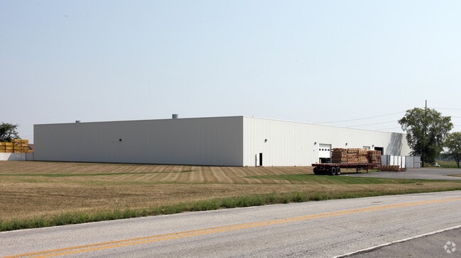
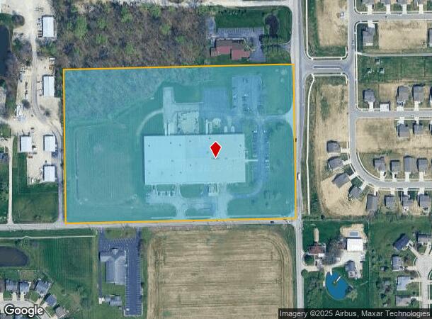
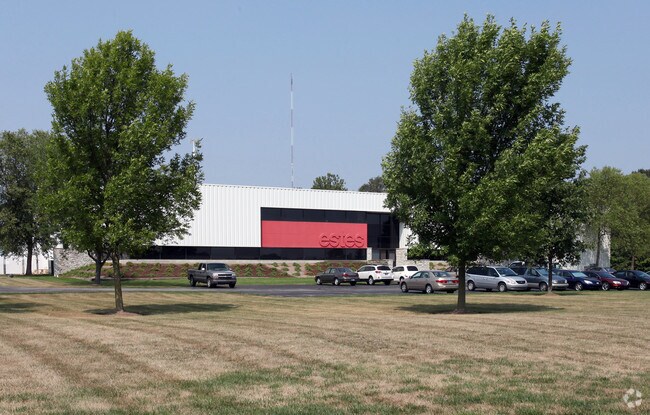
Property Record
470 S Mitthoeffer Rd, Indianapolis, IN 46239
NEARBY LISTINGS FOR SALE OR LEASE
Property Detail
470 S Mitthoeffer Rd
49-09-08-120-008.000-700
PT SE1/4 NE1/4 S8 T15 R5 BEG 668.71FT S OF NE CORS 668.12FT W 977.97FT N 668.12FT E 977.97FT TOBEG 15.02AC
Lightindustrial
Marion
X
Indiana
18097C0188F
15.02 AC
2023
Washington Square
2024
Indianapolis
390200
Indianapolis-Carmel-Anderson, IN
85,140 SF
DEMOGRAPHICS near 470 S Mitthoeffer Rd
1 Mile
3 Mile
5 Mile
2024 Total Population
3,546
44,275
138,339
2029 Population
3,473
43,729
137,805
Pop Growth 2024-2029
(2.06%)
(1.23%)
(0.39%)
Average Age
40
38
37
2024 Total Households
1,297
16,949
52,741
HH Growth 2024-2029
(2.16%)
(1.29%)
(0.44%)
Median Household Inc
$86,818
$65,880
$59,771
Avg Household Size
2.70
2.50
2.50
2024 Avg HH Vehicles
2.00
2.00
2.00
Median Home Value
$237,002
$175,657
$176,394
Median Year Built
1999
1978
1972
Nearby Places
Map Layers
Map Styles
 Street
 Aerial
- Restaurants
- Banks
- Shops
- Fitness
- Groceries
PUBLIC TRANSPORTATION
AIRPORT
Indianapolis International
DRIVE
WALK
Distance
Indianapolis International
41 min
22.5 mi
Freight Ports
Port of Toledo
DRIVE
WALK
Distance
Port of Toledo
269 min
225.5 mi
Nearby Properties
Address
Land Use
TOTAL SIZE
Lot Size
Zoning
Address
Land Use
TOTAL SIZE
Lot Size
Zoning
584,250 SF
42.54 AC
ZO01
Address
Land Use
TOTAL SIZE
Lot Size
Zoning
768,000 SF
29.62 AC
ZO03
Address
Land Use
TOTAL SIZE
Lot Size
Zoning
4,379 SF
11.48 AC
ZO01
Address
Land Use
TOTAL SIZE
Lot Size
Zoning
3,132 SF
20.50 AC
Address
Land Use
TOTAL SIZE
Lot Size
Zoning
133,257 SF
93.03 AC
ZO01
Address
Land Use
TOTAL SIZE
Lot Size
Zoning
5,620 SF
36.95 AC
ZO01
Address
Land Use
TOTAL SIZE
Lot Size
Zoning
1,768 SF
30.88 AC
ZO01
Address
Land Use
TOTAL SIZE
Lot Size
Zoning
76,663 SF
1.91 AC
ZO01
Address
Land Use
TOTAL SIZE
Lot Size
Zoning
213,102 SF
14.51 AC
Address
Land Use
TOTAL SIZE
Lot Size
Zoning
234,064 SF
29.49 AC
ZO01
Address
Land Use
TOTAL SIZE
Lot Size
Zoning
198,375 SF
24.52 AC
ZO01
Address
Land Use
TOTAL SIZE
Lot Size
Zoning
5,560 SF
10.88 AC
ZO01
Address
Land Use
TOTAL SIZE
Lot Size
Zoning
46,800 SF
49.64 AC
ZO01
Address
Land Use
TOTAL SIZE
Lot Size
Zoning
170,000 SF
11.29 AC
ZO01
Address
Land Use
TOTAL SIZE
Lot Size
Zoning
616,065 SF
51.20 AC
ZO01
Address
Land Use
TOTAL SIZE
Lot Size
Zoning
169,094 SF
10.43 AC
ZO01
Address
Land Use
TOTAL SIZE
Lot Size
Zoning
67,252 SF
7.50 AC
ZO01
Address
Land Use
TOTAL SIZE
Lot Size
Zoning
1,538 SF
14.49 AC
ZO01
Address
Land Use
TOTAL SIZE
Lot Size
Zoning
4,202 SF
19.62 AC
Address
Land Use
TOTAL SIZE
Lot Size
Zoning
140,976 SF
15.46 AC
ZO01
Address
Land Use
TOTAL SIZE
Lot Size
Zoning
53,988 SF
13.35 AC
ZO01
Address
Land Use
TOTAL SIZE
Lot Size
Zoning
76,456 SF
24.91 AC
Address
Land Use
TOTAL SIZE
Lot Size
Zoning
409,096 SF
26.01 AC
Address
Land Use
TOTAL SIZE
Lot Size
Zoning
113,863 SF
13.60 AC
Address
Land Use
TOTAL SIZE
Lot Size
Zoning
115,550 SF
11.58 AC
ZO01
Address
Land Use
TOTAL SIZE
Lot Size
Zoning
15,008 SF
18.12 AC
ZO01
Address
Land Use
TOTAL SIZE
Lot Size
Zoning
13,712 SF
26.10 AC
ZO01
Address
Land Use
TOTAL SIZE
Lot Size
Zoning
107,656 SF
7.66 AC
Address
Land Use
TOTAL SIZE
Lot Size
Zoning
160,410 SF
13.71 AC
Address
Land Use
TOTAL SIZE
Lot Size
Zoning
240,380 SF
44.81 AC
ZO01
The World's #1 Commercial Real Estate Marketplace
Connect with us
© 2026 CoStar Group
The information above has been obtained from sources believed reliable. While we do not doubt its accuracy we have not verified it and make no guarantee, warranty or representation about it. It is your responsibility to independently confirm its accuracy and completeness. Any projections, opinions, assumptions, or estimates used are for example only and do not represent the current or future performance of the property. The value of this transaction to you depends on tax and other factors which should be evaluated by your tax, financial, and legal advisors. You and your advisors should conduct a careful, independent investigation of the property to determine to your satisfaction the suitability of the property for your needs.