Property Record
470 S Us Highway 17, San Mateo, FL 32187
NEARBY LISTINGS FOR SALE OR LEASE
Property Detail
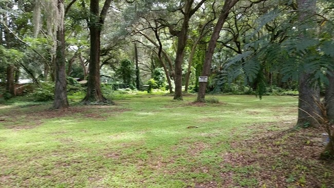
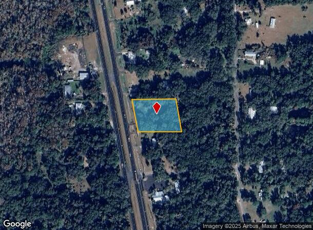
470 S Us Highway 17
39-10-27-0000-0160-0000
J B Entralgo Grant
Parkinglot
PT OF ENTRALGO GRT BK163 P123, (EX OR168 P47 RD) (MAP SHEET, 21 39D + 48A)
X
Putnam
12107C0327C
Florida
2025
1.38 AC
2025
Florida Central North Area
951100
Other Market Areas
4,076 SF
Palatka, FL
DEMOGRAPHICS near 470 S Us Highway 17
1 Mile
3 Mile
5 Mile
2024 Total Population
623
4,297
16,785
2029 Population
647
4,484
17,416
Pop Growth 2024-2029
+ 3.85%
+ 4.35%
+ 3.76%
Average Age
44
45
43
2024 Total Households
259
1,810
6,849
HH Growth 2024-2029
+ 3.86%
+ 4.42%
+ 3.77%
Median Household Inc
$34,515
$38,024
$33,387
Avg Household Size
2.40
2.30
2.40
2024 Avg HH Vehicles
2.00
2.00
2.00
Median Home Value
$135,000
$150,126
$123,282
Median Year Built
1990
1986
1974
Nearby Places
Map Layers
Map Styles
 Street
 Aerial
- Restaurants
- Banks
- Shops
- Fitness
- Groceries
PUBLIC TRANSPORTATION
COMMUTER RAIL
Palatka Amtrak (Silver Meteor - Amtrak, Silver Star - Amtrak)
DRIVE
WALK
Distance
Palatka Amtrak (Silver Meteor - Amtrak, Silver Star - Amtrak)
9 min
5.1 mi
Freight Ports
Jacksonville Port
DRIVE
WALK
Distance
Jacksonville Port
82 min
64.8 mi
SALE & LEASE HISTORY
LISTING DATE
SALE/LEASE

Sep 24, 2016
For Sale
Nearby Properties
Address
Land Use
TOTAL SIZE
Lot Size
Zoning
Address
Land Use
TOTAL SIZE
Lot Size
Zoning
42,106 SF
15.24 AC
Address
Land Use
TOTAL SIZE
Lot Size
Zoning
19,096 SF
151.97 AC
Address
Land Use
TOTAL SIZE
Lot Size
Zoning
6,892 SF
29 AC
Address
Land Use
TOTAL SIZE
Lot Size
Zoning
13,054 SF
2.25 AC
Address
Land Use
TOTAL SIZE
Lot Size
Zoning
49,514 SF
9 AC
Address
Land Use
TOTAL SIZE
Lot Size
Zoning
1,984 SF
25.01 AC
Address
Land Use
TOTAL SIZE
Lot Size
Zoning
Address
Land Use
TOTAL SIZE
Lot Size
Zoning
12,427 SF
16.63 AC
Address
Land Use
TOTAL SIZE
Lot Size
Zoning
2,829 SF
1.31 AC
Address
Land Use
TOTAL SIZE
Lot Size
Zoning
10,007 SF
1.35 AC
Address
Land Use
TOTAL SIZE
Lot Size
Zoning
2,648 SF
4.18 AC
Address
Land Use
TOTAL SIZE
Lot Size
Zoning
Address
Land Use
TOTAL SIZE
Lot Size
Zoning
3,571 SF
1.30 AC
Address
Land Use
TOTAL SIZE
Lot Size
Zoning
7,026 SF
3.02 AC
Address
Land Use
TOTAL SIZE
Lot Size
Zoning
4,194 SF
2.96 AC
Address
Land Use
TOTAL SIZE
Lot Size
Zoning
3,391 SF
8.55 AC
Address
Land Use
TOTAL SIZE
Lot Size
Zoning
4,502 SF
8.63 AC
Address
Land Use
TOTAL SIZE
Lot Size
Zoning
Address
Land Use
TOTAL SIZE
Lot Size
Zoning
11,448 SF
2.31 AC
Address
Land Use
TOTAL SIZE
Lot Size
Zoning
8,990 SF
2.16 AC
Address
Land Use
TOTAL SIZE
Lot Size
Zoning
12,624 SF
1.39 AC
Address
Land Use
TOTAL SIZE
Lot Size
Zoning
7,684 SF
1.43 AC
Address
Land Use
TOTAL SIZE
Lot Size
Zoning
8,990 SF
1.58 AC
Address
Land Use
TOTAL SIZE
Lot Size
Zoning
2,371 SF
1.20 AC
Address
Land Use
TOTAL SIZE
Lot Size
Zoning
2,825 SF
2.34 AC
Address
Land Use
TOTAL SIZE
Lot Size
Zoning
2,112 SF
0.58 AC
Address
Land Use
TOTAL SIZE
Lot Size
Zoning
2,220 SF
9.78 AC
Address
Land Use
TOTAL SIZE
Lot Size
Zoning
5,812 SF
2.39 AC
Address
Land Use
TOTAL SIZE
Lot Size
Zoning
4,052 SF
8.22 AC
Address
Land Use
TOTAL SIZE
Lot Size
Zoning
4,012 SF
1.85 AC
The World's #1 Commercial Real Estate Marketplace
Connect with us
© 2025 CoStar Group
The information above has been obtained from sources believed reliable. While we do not doubt its accuracy we have not verified it and make no guarantee, warranty or representation about it. It is your responsibility to independently confirm its accuracy and completeness. Any projections, opinions, assumptions, or estimates used are for example only and do not represent the current or future performance of the property. The value of this transaction to you depends on tax and other factors which should be evaluated by your tax, financial, and legal advisors. You and your advisors should conduct a careful, independent investigation of the property to determine to your satisfaction the suitability of the property for your needs.