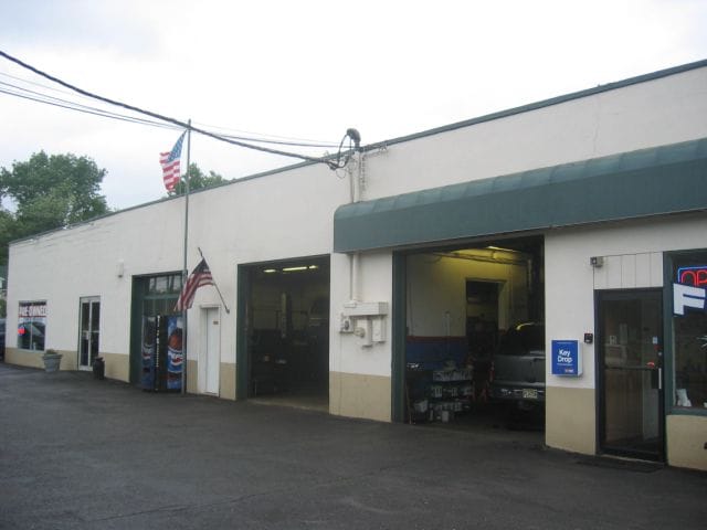
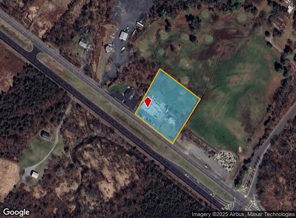
Property Record
470 Us Highway 22 W, Whitehouse Station, NJ 08889

NEARBY LISTINGS FOR SALE OR LEASE
Property Detail
470 Us Highway 22 W
22-00004-0000-00046
Hunterdon
Commercialnec
New Jersey
X
46
34019C0143F
1.99 AC
2024
Route 78 West
2025
Northern New Jersey
011100
Newark, NJ-PA
1,872 SF
DEMOGRAPHICS near 470 Us Highway 22 W
1 Mile
3 Mile
5 Mile
2024 Total Population
2,082
11,413
23,085
2029 Population
2,143
11,564
23,326
Pop Growth 2024-2029
+ 2.93%
+ 1.32%
+ 1.04%
Average Age
46
46
45
2024 Total Households
870
4,669
9,054
HH Growth 2024-2029
+ 2.53%
+ 1.31%
+ 1.03%
Median Household Inc
$98,290
$122,050
$134,185
Avg Household Size
2.40
2.40
2.50
2024 Avg HH Vehicles
2.00
2.00
2.00
Median Home Value
$469,444
$479,056
$514,284
Median Year Built
1993
1980
1981
Nearby Places
Map Layers
Map Styles
 Street
 Aerial
- Restaurants
- Banks
- Shops
- Fitness
- Groceries
SALE & LEASE HISTORY
LISTING DATE
SALE/LEASE

Nov 11, 2019
For Sale
Nov 03, 2018
For Lease
Jul 08, 2019
For Lease
Aug 12, 2023
For Sale
Nearby Properties
Address
Land Use
TOTAL SIZE
Lot Size
Zoning
Address
Land Use
TOTAL SIZE
Lot Size
Zoning
187,596 SF
54.59 AC
RO
Address
Land Use
TOTAL SIZE
Lot Size
Zoning
61.69 AC
RO
Address
Land Use
TOTAL SIZE
Lot Size
Zoning
8,000 SF
17.12 AC
RO
Address
Land Use
TOTAL SIZE
Lot Size
Zoning
29,982 SF
7.76 AC
Address
Land Use
TOTAL SIZE
Lot Size
Zoning
76.99 AC
ROM2
Address
Land Use
TOTAL SIZE
Lot Size
Zoning
14,182 SF
77.17 AC
ROMX
Address
Land Use
TOTAL SIZE
Lot Size
Zoning
20 AC
AR
Address
Land Use
TOTAL SIZE
Lot Size
Zoning
10,863 SF
77 AC
ROM1
Address
Land Use
TOTAL SIZE
Lot Size
Zoning
58,471 SF
8.69 AC
B
Address
Land Use
TOTAL SIZE
Lot Size
Zoning
20,048 SF
3 AC
AR
Address
Land Use
TOTAL SIZE
Lot Size
Zoning
20,764 SF
21.01 AC
ROM1
Address
Land Use
TOTAL SIZE
Lot Size
Zoning
4,990 SF
254.59 AC
AH1
Address
Land Use
TOTAL SIZE
Lot Size
Zoning
6.80 AC
VR
Address
Land Use
TOTAL SIZE
Lot Size
Zoning
4.61 AC
Address
Land Use
TOTAL SIZE
Lot Size
Zoning
6.52 AC
B
Address
Land Use
TOTAL SIZE
Lot Size
Zoning
11.28 AC
ROM1
Address
Land Use
TOTAL SIZE
Lot Size
Zoning
10.99 AC
ROM1
Address
Land Use
TOTAL SIZE
Lot Size
Zoning
25 AC
RC
Address
Land Use
TOTAL SIZE
Lot Size
Zoning
1,056 SF
4 AC
Address
Land Use
TOTAL SIZE
Lot Size
Zoning
Address
Land Use
TOTAL SIZE
Lot Size
Zoning
37,951 SF
21.49 AC
AR
Address
Land Use
TOTAL SIZE
Lot Size
Zoning
9,200 SF
10.95 AC
Address
Land Use
TOTAL SIZE
Lot Size
Zoning
62,140 SF
6 AC
B
Address
Land Use
TOTAL SIZE
Lot Size
Zoning
7,782 SF
10 AC
ROM2
Address
Land Use
TOTAL SIZE
Lot Size
Zoning
Address
Land Use
TOTAL SIZE
Lot Size
Zoning
3,840 SF
5.72 AC
PO
Address
Land Use
TOTAL SIZE
Lot Size
Zoning
19,112 SF
51.81 AC
PM
Address
Land Use
TOTAL SIZE
Lot Size
Zoning
26 AC
RO
Address
Land Use
TOTAL SIZE
Lot Size
Zoning
2.19 AC
Address
Land Use
TOTAL SIZE
Lot Size
Zoning
53,392 SF
7.47 AC
PND1
The World's #1 Commercial Real Estate Marketplace
Connect with us
© 2025 CoStar Group
The information above has been obtained from sources believed reliable. While we do not doubt its accuracy we have not verified it and make no guarantee, warranty or representation about it. It is your responsibility to independently confirm its accuracy and completeness. Any projections, opinions, assumptions, or estimates used are for example only and do not represent the current or future performance of the property. The value of this transaction to you depends on tax and other factors which should be evaluated by your tax, financial, and legal advisors. You and your advisors should conduct a careful, independent investigation of the property to determine to your satisfaction the suitability of the property for your needs.