Property Record
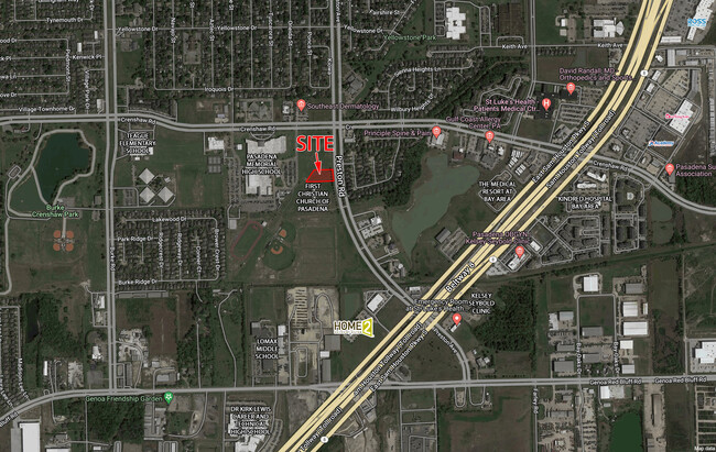
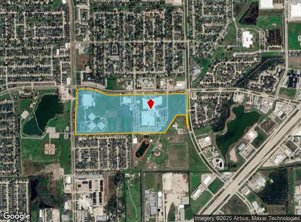
4320 Crenshaw Rd, Pasadena, TX 77504
This Property Is For Sale
NEARBY LISTINGS FOR SALE OR LEASE
Property Detail
4320 Crenshaw Rd
0451980000020
Abst 894 Wcrr Co Sec 7
Publicschool
TR 19 ABST 894 WCRR CO SEC 7 BLK 7
AE
Harris
48201C0920M
Texas
0
75 AC
2025
Gulf Freeway/Pasadena
324000
Houston
270,000 SF
Houston-Pasadena-The Woodlands, TX
DEMOGRAPHICS near 4320 Crenshaw Rd
1 Mile
3 Mile
5 Mile
2024 Total Population
10,968
85,514
294,805
2029 Population
11,170
87,323
300,413
Pop Growth 2024-2029
+ 1.84%
+ 2.12%
+ 1.90%
Average Age
38
36
36
2024 Total Households
3,976
29,544
98,567
HH Growth 2024-2029
+ 1.86%
+ 2.04%
+ 1.88%
Median Household Inc
$79,037
$56,613
$62,676
Avg Household Size
2.70
2.80
2.90
2024 Avg HH Vehicles
2.00
2.00
2.00
Median Home Value
$225,649
$197,912
$182,421
Median Year Built
1982
1982
1978
Nearby Places
Map Layers
Map Styles
 Street
 Aerial
- Restaurants
- Banks
- Shops
- Fitness
- Groceries
PUBLIC TRANSPORTATION
AIRPORT
William P Hobby
DRIVE
WALK
Distance
William P Hobby
19 min
7.9 mi
George Bush Intcntl/Houston
DRIVE
WALK
Distance
George Bush Intcntl/Houston
43 min
33.2 mi
Freight Ports
Port of Houston
DRIVE
WALK
Distance
Port of Houston
24 min
11.5 mi
Nearby Properties
Address
Land Use
TOTAL SIZE
Lot Size
Zoning
Address
Land Use
TOTAL SIZE
Lot Size
Zoning
6,478,017 SF
135.61 AC
Address
Land Use
TOTAL SIZE
Lot Size
Zoning
552,961 SF
25.01 AC
Address
Land Use
TOTAL SIZE
Lot Size
Zoning
345,420 SF
4.02 AC
Address
Land Use
TOTAL SIZE
Lot Size
Zoning
236,508 SF
24.19 AC
Address
Land Use
TOTAL SIZE
Lot Size
Zoning
309,779 SF
19.57 AC
Address
Land Use
TOTAL SIZE
Lot Size
Zoning
135.61 AC
Address
Land Use
TOTAL SIZE
Lot Size
Zoning
414,017 SF
19.28 AC
Address
Land Use
TOTAL SIZE
Lot Size
Zoning
173,293 SF
19.70 AC
Address
Land Use
TOTAL SIZE
Lot Size
Zoning
226,250 SF
13.69 AC
Address
Land Use
TOTAL SIZE
Lot Size
Zoning
359,223 SF
17.24 AC
Address
Land Use
TOTAL SIZE
Lot Size
Zoning
331,734 SF
15.82 AC
Address
Land Use
TOTAL SIZE
Lot Size
Zoning
283,010 SF
14.61 AC
Address
Land Use
TOTAL SIZE
Lot Size
Zoning
281,470 SF
11.24 AC
Address
Land Use
TOTAL SIZE
Lot Size
Zoning
112,782 SF
8.18 AC
Address
Land Use
TOTAL SIZE
Lot Size
Zoning
276,029 SF
14.44 AC
Address
Land Use
TOTAL SIZE
Lot Size
Zoning
397,739 SF
15.93 AC
Address
Land Use
TOTAL SIZE
Lot Size
Zoning
260,915 SF
15.98 AC
Address
Land Use
TOTAL SIZE
Lot Size
Zoning
147,671 SF
17.84 AC
Address
Land Use
TOTAL SIZE
Lot Size
Zoning
342,149 SF
23.56 AC
Address
Land Use
TOTAL SIZE
Lot Size
Zoning
157,845 SF
12.52 AC
Address
Land Use
TOTAL SIZE
Lot Size
Zoning
800,000 SF
135.61 AC
Address
Land Use
TOTAL SIZE
Lot Size
Zoning
230,218 SF
10.67 AC
Address
Land Use
TOTAL SIZE
Lot Size
Zoning
219,143 SF
10.84 AC
Address
Land Use
TOTAL SIZE
Lot Size
Zoning
120,304 SF
7.55 AC
Address
Land Use
TOTAL SIZE
Lot Size
Zoning
219,424 SF
7.25 AC
Address
Land Use
TOTAL SIZE
Lot Size
Zoning
Address
Land Use
TOTAL SIZE
Lot Size
Zoning
203,158 SF
10 AC
Address
Land Use
TOTAL SIZE
Lot Size
Zoning
105,885 SF
10.19 AC
Address
Land Use
TOTAL SIZE
Lot Size
Zoning
241,245 SF
9 AC
Address
Land Use
TOTAL SIZE
Lot Size
Zoning
203,931 SF
25.06 AC
The World's #1 Commercial Real Estate Marketplace
Connect with us
© 2026 CoStar Group
The information above has been obtained from sources believed reliable. While we do not doubt its accuracy we have not verified it and make no guarantee, warranty or representation about it. It is your responsibility to independently confirm its accuracy and completeness. Any projections, opinions, assumptions, or estimates used are for example only and do not represent the current or future performance of the property. The value of this transaction to you depends on tax and other factors which should be evaluated by your tax, financial, and legal advisors. You and your advisors should conduct a careful, independent investigation of the property to determine to your satisfaction the suitability of the property for your needs.