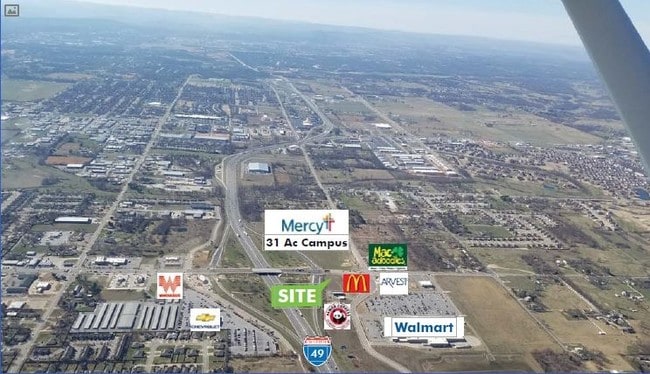
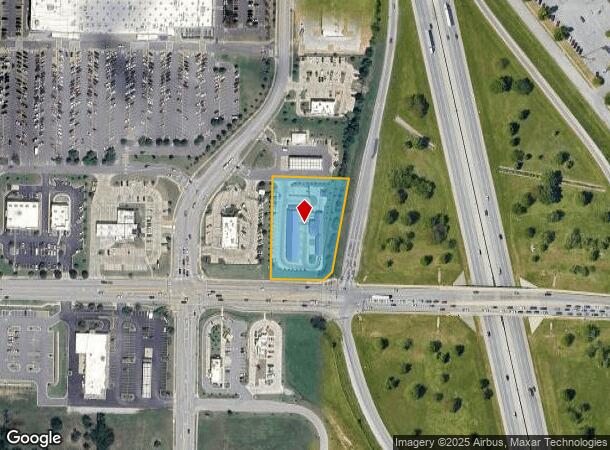
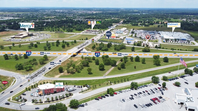
Property Record
4700 Elm Springs Rd, Springdale, AR 72762
NEARBY LISTINGS FOR SALE OR LEASE
Property Detail
4700 Elm Springs Rd
815-39269-000
Hall Crossing
Carwashautomated
Washington
X
Arkansas
05143C0060G
6
2025
1.58 AC
2025
Greater Springdale
010519
Fayetteville/Springdale/Rogers
3,348 SF
Fayetteville-Springdale-Rogers, AR-MO
DEMOGRAPHICS near 4700 Elm Springs Rd
1 Mile
3 Mile
5 Mile
2024 Total Population
5,703
45,411
107,319
2029 Population
6,218
49,988
119,195
Pop Growth 2024-2029
+ 9.03%
+ 10.08%
+ 11.07%
Average Age
37
36
35
2024 Total Households
1,815
15,329
35,539
HH Growth 2024-2029
+ 9.26%
+ 10.37%
+ 11.24%
Median Household Inc
$72,664
$69,032
$67,983
Avg Household Size
3.00
2.80
2.90
2024 Avg HH Vehicles
2.00
2.00
2.00
Median Home Value
$191,422
$219,325
$233,708
Median Year Built
1994
1992
1996
Nearby Places
Map Layers
Map Styles
 Street
 Aerial
- Restaurants
- Banks
- Shops
- Fitness
- Groceries
PUBLIC TRANSPORTATION
AIRPORT
Northwest Arkansas Ntl
DRIVE
WALK
Distance
Northwest Arkansas Ntl
29 min
12.2 mi
Freight Ports
Tulsa Port of Inola
DRIVE
WALK
Distance
Tulsa Port of Inola
99 min
85.3 mi
SALE & LEASE HISTORY
LISTING DATE
SALE/LEASE

Sep 24, 2016
For Sale
Mar 12, 2020
For Sale
Jun 18, 2019
For Sale
Nearby Properties
Address
Land Use
TOTAL SIZE
Lot Size
Zoning
Address
Land Use
TOTAL SIZE
Lot Size
Zoning
132,060 SF
8 AC
Address
Land Use
TOTAL SIZE
Lot Size
Zoning
58,764 SF
1.56 AC
Address
Land Use
TOTAL SIZE
Lot Size
Zoning
403,089 SF
1.93 AC
Address
Land Use
TOTAL SIZE
Lot Size
Zoning
54,448 SF
19.43 AC
Address
Land Use
TOTAL SIZE
Lot Size
Zoning
75,774 SF
16.49 AC
Address
Land Use
TOTAL SIZE
Lot Size
Zoning
181,734 SF
21.02 AC
Address
Land Use
TOTAL SIZE
Lot Size
Zoning
15,347 SF
6.27 AC
Address
Land Use
TOTAL SIZE
Lot Size
Zoning
437,349 SF
40.29 AC
Address
Land Use
TOTAL SIZE
Lot Size
Zoning
106,141 SF
2.82 AC
Address
Land Use
TOTAL SIZE
Lot Size
Zoning
153,718 SF
Address
Land Use
TOTAL SIZE
Lot Size
Zoning
81,000 SF
7.01 AC
Address
Land Use
TOTAL SIZE
Lot Size
Zoning
78,374 SF
8.79 AC
Address
Land Use
TOTAL SIZE
Lot Size
Zoning
112,817 SF
9.57 AC
Address
Land Use
TOTAL SIZE
Lot Size
Zoning
196,657 SF
18.82 AC
Address
Land Use
TOTAL SIZE
Lot Size
Zoning
117,690 SF
2.38 AC
Address
Land Use
TOTAL SIZE
Lot Size
Zoning
176,204 SF
7.57 AC
Address
Land Use
TOTAL SIZE
Lot Size
Zoning
193,140 SF
21.31 AC
Address
Land Use
TOTAL SIZE
Lot Size
Zoning
89,280 SF
12.22 AC
Address
Land Use
TOTAL SIZE
Lot Size
Zoning
134,342 SF
14.95 AC
Address
Land Use
TOTAL SIZE
Lot Size
Zoning
140,755 SF
14.15 AC
Address
Land Use
TOTAL SIZE
Lot Size
Zoning
16,698 SF
1.11 AC
Address
Land Use
TOTAL SIZE
Lot Size
Zoning
229,158 SF
21.23 AC
C2
Address
Land Use
TOTAL SIZE
Lot Size
Zoning
180,412 SF
13.14 AC
Address
Land Use
TOTAL SIZE
Lot Size
Zoning
167,040 SF
19.98 AC
Address
Land Use
TOTAL SIZE
Lot Size
Zoning
21,208 SF
1.89 AC
C2
Address
Land Use
TOTAL SIZE
Lot Size
Zoning
85,874 SF
2.76 AC
Address
Land Use
TOTAL SIZE
Lot Size
Zoning
16,760 SF
2.96 AC
Address
Land Use
TOTAL SIZE
Lot Size
Zoning
12,882 SF
12.33 AC
Address
Land Use
TOTAL SIZE
Lot Size
Zoning
31,150 SF
3.74 AC
C1
Address
Land Use
TOTAL SIZE
Lot Size
Zoning
80,475 SF
0.45 AC
C3
The World's #1 Commercial Real Estate Marketplace
Connect with us
© 2025 CoStar Group
The information above has been obtained from sources believed reliable. While we do not doubt its accuracy we have not verified it and make no guarantee, warranty or representation about it. It is your responsibility to independently confirm its accuracy and completeness. Any projections, opinions, assumptions, or estimates used are for example only and do not represent the current or future performance of the property. The value of this transaction to you depends on tax and other factors which should be evaluated by your tax, financial, and legal advisors. You and your advisors should conduct a careful, independent investigation of the property to determine to your satisfaction the suitability of the property for your needs.