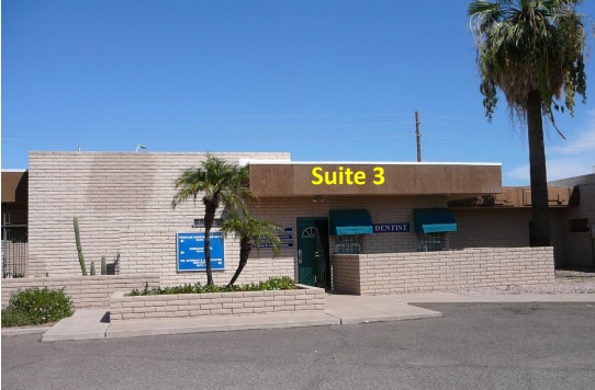
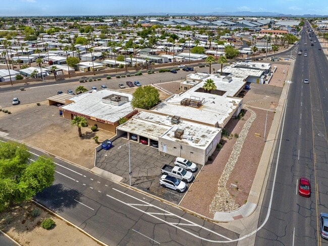
Property Record
4700 N 51St Ave, Phoenix, AZ 85031

Property Detail
4700 N 51St Ave
144-44-013
MARYVALE PARKWAY MEDICAL CENTER TRACT A MCR 110-19
Medicalbuilding
Maricopa
M-H
Arizona
C and X Area of minimal flood hazard, usually depicted on FIRMs as above the 500-year flood level.
1
2025
0.45 AC
2025
Northwest Phoenix
109402
Phoenix
4,258 SF
Phoenix-Mesa-Chandler, AZ
NEARBY LISTINGS FOR SALE OR LEASE
DEMOGRAPHICS near 4700 N 51St Ave
1 mile
3 mile
5 mile
2025 Total Population
18,683
232,824
529,748
2030 Population
19,203
239,367
546,484
Pop Growth 2025-2030
+ 2.78%
+ 2.81%
+ 3.16%
Average Age
34
33
34
2025 Total Households
5,342
65,463
163,252
HH Growth 2025-2030
+ 3.01%
+ 3.07%
+ 3.35%
Median Household Inc
$58,202
$56,939
$59,079
Avg Household Size
3.20
3.30
3.10
2025 Avg HH Vehicles
2.00
2.00
2.00
Median Home Value
$251,755
$290,151
$324,358
Median Year Built
1971
1973
1975
Nearby Places
Map Layers
Map Styles
 Street
 Aerial
Layers
 Traffic
 Biking
Places
Listings with unknown addresses are not visible on the map
- Restaurants
- Banks
- Shops
- Fitness
- Groceries
SALE & LEASE HISTORY
LISTING DATE
SALE/LEASE

Sep 26, 2023
For Lease
Sep 24, 2016
For Sale
Sep 01, 2022
For Sale
May 05, 2025
For Sale
Mar 11, 2025
For Sale
Jun 28, 2021
For Lease
Jun 18, 2025
For Sale
Jun 01, 2020
For Sale
Nearby Properties
Address
Land Use
TOTAL SIZE
Lot Size
Zoning
Address
Land Use
TOTAL SIZE
Lot Size
Zoning
69,542 SF
4.92 AC
I-P
Address
Land Use
TOTAL SIZE
Lot Size
Zoning
42,631 SF
2.90 AC
A-2
Address
Land Use
TOTAL SIZE
Lot Size
Zoning
281,038 SF
7.71 AC
Address
Land Use
TOTAL SIZE
Lot Size
Zoning
337,487 SF
39 AC
R-6
Address
Land Use
TOTAL SIZE
Lot Size
Zoning
629,928 SF
41.37 AC
Address
Land Use
TOTAL SIZE
Lot Size
Zoning
316,386 SF
45.04 AC
R16
Address
Land Use
TOTAL SIZE
Lot Size
Zoning
25.91 AC
A1
Address
Land Use
TOTAL SIZE
Lot Size
Zoning
350,874 SF
28.66 AC
C-C
Address
Land Use
TOTAL SIZE
Lot Size
Zoning
211,015 SF
9.59 AC
R-6
Address
Land Use
TOTAL SIZE
Lot Size
Zoning
262,609 SF
18.96 AC
I-1
Address
Land Use
TOTAL SIZE
Lot Size
Zoning
200,998 SF
0.06 AC
C-C
Address
Land Use
TOTAL SIZE
Lot Size
Zoning
187,309 SF
19.99 AC
R-6
Address
Land Use
TOTAL SIZE
Lot Size
Zoning
74,208 SF
7.25 AC
I-P
Address
Land Use
TOTAL SIZE
Lot Size
Zoning
217,214 SF
27.12 AC
R-6
Address
Land Use
TOTAL SIZE
Lot Size
Zoning
132,597 SF
59.45 AC
C-2
Address
Land Use
TOTAL SIZE
Lot Size
Zoning
18,296 SF
0.93 AC
I-P
Address
Land Use
TOTAL SIZE
Lot Size
Zoning
367,133 SF
17.88 AC
IND.PK.
Address
Land Use
TOTAL SIZE
Lot Size
Zoning
706,747 SF
13.54 AC
R-5
Address
Land Use
TOTAL SIZE
Lot Size
Zoning
13,678 SF
1.88 AC
R-6
Address
Land Use
TOTAL SIZE
Lot Size
Zoning
139,343 SF
10.13 AC
R-6
Address
Land Use
TOTAL SIZE
Lot Size
Zoning
120,680 SF
19.15 AC
A-1
Address
Land Use
TOTAL SIZE
Lot Size
Zoning
134,215 SF
17.75 AC
R-6
Address
Land Use
TOTAL SIZE
Lot Size
Zoning
116,276 SF
11.58 AC
R-6
Address
Land Use
TOTAL SIZE
Lot Size
Zoning
208,448 SF
19.04 AC
C-C
Address
Land Use
TOTAL SIZE
Lot Size
Zoning
153,190 SF
24.67 AC
AG
Address
Land Use
TOTAL SIZE
Lot Size
Zoning
117,165 SF
19.15 AC
M-H
Address
Land Use
TOTAL SIZE
Lot Size
Zoning
305,998 SF
23.38 AC
I-1
Address
Land Use
TOTAL SIZE
Lot Size
Zoning
206,428 SF
18.02 AC
C-C
Address
Land Use
TOTAL SIZE
Lot Size
Zoning
328,069 SF
16.34 AC
R-6
Address
Land Use
TOTAL SIZE
Lot Size
Zoning
114,424 SF
10.88 AC
R-6
The World's #1 Commercial Real Estate Marketplace
Connect with us
© 2026 CoStar Group
The information above has been obtained from sources believed reliable. While we do not doubt its accuracy we have not verified it and make no guarantee, warranty or representation about it. It is your responsibility to independently confirm its accuracy and completeness. Any projections, opinions, assumptions, or estimates used are for example only and do not represent the current or future performance of the property. The value of this transaction to you depends on tax and other factors which should be evaluated by your tax, financial, and legal advisors. You and your advisors should conduct a careful, independent investigation of the property to determine to your satisfaction the suitability of the property for your needs.