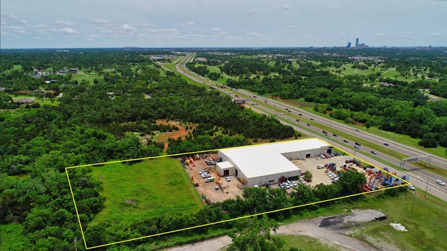
Property Record
4700 N Bryant Ave, Oklahoma City, OK 73121


Current Lease Availabilities
NEARBY LISTINGS FOR SALE OR LEASE
Property Detail
4700 N Bryant Ave
Oklahoma City, OK
Crutcho Township
255183040
CRUTCHO TOWNSHIP PT OF NW4 SEC 18 12N 2W S 1/2 OF FOLL DESC BEG 1RD N SW/C LOT 1 OF NW4 TH E TO A PT 7 CHAINS 50 7/50 LINKS W & 1RD N OFSE/C OF SD LOT 1 TH N642.5FT TH W TO A TR DEEDED TO COUNTY TH SWLY & S TO BEG
Warehouse
Oklahoma
X
Oklahoma
40109C0190H
1
2023
3.67 AC
2024
East Outlying
106000
Oklahoma City
35,040 SF
DEMOGRAPHICS near 4700 N Bryant Ave
1 Mile
3 Mile
5 Mile
2024 Total Population
505
23,785
93,346
2029 Population
514
24,807
96,436
Pop Growth 2024-2029
+ 1.78%
+ 4.30%
+ 3.31%
Average Age
47
41
39
2024 Total Households
199
10,390
42,657
HH Growth 2024-2029
+ 2.01%
+ 4.42%
+ 3.42%
Median Household Inc
$87,500
$36,123
$46,586
Avg Household Size
2.50
2.10
2.10
2024 Avg HH Vehicles
3.00
2.00
2.00
Median Home Value
$263,281
$112,325
$170,845
Median Year Built
1963
1958
1963
Nearby Places
Map Layers
Map Styles
 Street
 Aerial
- Restaurants
- Banks
- Shops
- Fitness
- Groceries
PUBLIC TRANSPORTATION
COMMUTER RAIL
Oklahoma City (Heartland Flyer - Amtrak)
DRIVE
WALK
Distance
Oklahoma City (Heartland Flyer - Amtrak)
10 min
7.1 mi
AIRPORT
Will Rogers World
DRIVE
WALK
Distance
Will Rogers World
28 min
16.5 mi
Freight Ports
Tulsa Port Of Catoosa
DRIVE
WALK
Distance
Tulsa Port Of Catoosa
126 min
117.7 mi
Nearby Properties
Address
Land Use
TOTAL SIZE
Lot Size
Zoning
Address
Land Use
TOTAL SIZE
Lot Size
Zoning
442,553 SF
58.86 AC
PUD
Address
Land Use
TOTAL SIZE
Lot Size
Zoning
327,248 SF
14.22 AC
R-4
Address
Land Use
TOTAL SIZE
Lot Size
Zoning
93,244 SF
7.54 AC
PUD
Address
Land Use
TOTAL SIZE
Lot Size
Zoning
241,874 SF
36.89 AC
PUD
Address
Land Use
TOTAL SIZE
Lot Size
Zoning
377,880 SF
24.34 AC
PUD
Address
Land Use
TOTAL SIZE
Lot Size
Zoning
280,970 SF
24.32 AC
Address
Land Use
TOTAL SIZE
Lot Size
Zoning
39,800 SF
4.10 AC
PUD
Address
Land Use
TOTAL SIZE
Lot Size
Zoning
198,422 SF
4.17 AC
O-2
Address
Land Use
TOTAL SIZE
Lot Size
Zoning
142,592 SF
6.60 AC
PUD
Address
Land Use
TOTAL SIZE
Lot Size
Zoning
160,816 SF
16.14 AC
Address
Land Use
TOTAL SIZE
Lot Size
Zoning
160,849 SF
11.65 AC
C-3
Address
Land Use
TOTAL SIZE
Lot Size
Zoning
151,319 SF
3.43 AC
O-2
Address
Land Use
TOTAL SIZE
Lot Size
Zoning
171,139 SF
11.06 AC
I-2
Address
Land Use
TOTAL SIZE
Lot Size
Zoning
46,390 SF
14.13 AC
Address
Land Use
TOTAL SIZE
Lot Size
Zoning
131,180 SF
12.90 AC
I-2
Address
Land Use
TOTAL SIZE
Lot Size
Zoning
30,501 SF
2.48 AC
R-1
Address
Land Use
TOTAL SIZE
Lot Size
Zoning
110,172 SF
33.65 AC
PUD
Address
Land Use
TOTAL SIZE
Lot Size
Zoning
9,016 SF
0.51 AC
Address
Land Use
TOTAL SIZE
Lot Size
Zoning
7,360 SF
4.69 AC
SPUD
Address
Land Use
TOTAL SIZE
Lot Size
Zoning
37,335 SF
2.03 AC
Address
Land Use
TOTAL SIZE
Lot Size
Zoning
115,845 SF
14.28 AC
R-4
Address
Land Use
TOTAL SIZE
Lot Size
Zoning
111,924 SF
10.83 AC
SPUD
Address
Land Use
TOTAL SIZE
Lot Size
Zoning
84,116 SF
5.68 AC
R-4
Address
Land Use
TOTAL SIZE
Lot Size
Zoning
6,000 SF
2.24 AC
C-3
Address
Land Use
TOTAL SIZE
Lot Size
Zoning
54,680 SF
2.20 AC
O-2
Address
Land Use
TOTAL SIZE
Lot Size
Zoning
50,042 SF
150 AC
Address
Land Use
TOTAL SIZE
Lot Size
Zoning
11,179 SF
20.92 AC
PUD
Address
Land Use
TOTAL SIZE
Lot Size
Zoning
63,843 SF
3.02 AC
I-2
Address
Land Use
TOTAL SIZE
Lot Size
Zoning
62,409 SF
7.46 AC
SPUD
Address
Land Use
TOTAL SIZE
Lot Size
Zoning
26,705 SF
12.34 AC
AA
The World's #1 Commercial Real Estate Marketplace
Connect with us
© 2026 CoStar Group
The information above has been obtained from sources believed reliable. While we do not doubt its accuracy we have not verified it and make no guarantee, warranty or representation about it. It is your responsibility to independently confirm its accuracy and completeness. Any projections, opinions, assumptions, or estimates used are for example only and do not represent the current or future performance of the property. The value of this transaction to you depends on tax and other factors which should be evaluated by your tax, financial, and legal advisors. You and your advisors should conduct a careful, independent investigation of the property to determine to your satisfaction the suitability of the property for your needs.