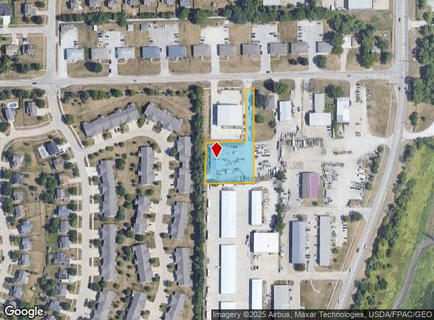
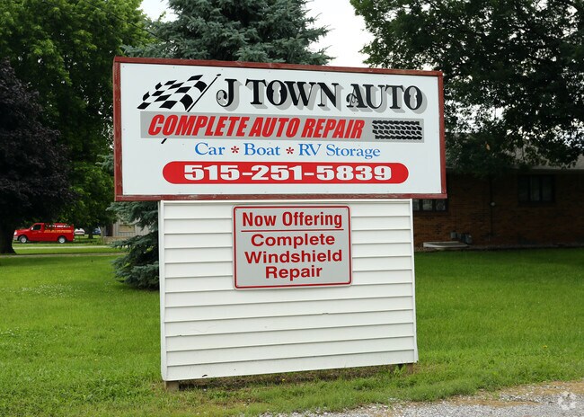
Property Record
4700 Nw 62Nd Ave, Johnston, IA 50131

NEARBY LISTINGS FOR SALE OR LEASE
Property Detail
4700 Nw 62Nd Ave
Des Moines-West Des Moines, IA
Thieleke Acres
241-01000012102
LOT 2 THIELEKE ACRES
Miscellaneous
Polk
X
Iowa
19153C0195F
2
2024
0.94 AC
2025
Western Suburbs
011702
Des Moines
435 SF
DEMOGRAPHICS near 4700 Nw 62Nd Ave
1 Mile
3 Mile
5 Mile
2024 Total Population
5,161
34,787
145,220
2029 Population
5,407
35,944
150,769
Pop Growth 2024-2029
+ 4.77%
+ 3.33%
+ 3.82%
Average Age
39
39
38
2024 Total Households
2,147
13,703
57,324
HH Growth 2024-2029
+ 5.12%
+ 3.61%
+ 3.97%
Median Household Inc
$77,625
$82,793
$79,013
Avg Household Size
2.40
2.50
2.40
2024 Avg HH Vehicles
2.00
2.00
2.00
Median Home Value
$262,800
$249,560
$234,028
Median Year Built
1999
1986
1978
Nearby Places
Map Layers
Map Styles
 Street
 Aerial
- Restaurants
- Banks
- Shops
- Fitness
- Groceries
PUBLIC TRANSPORTATION
AIRPORT
Des Moines International
DRIVE
WALK
Distance
Des Moines International
24 min
12.0 mi
Freight Ports
Port Milwaukee
DRIVE
WALK
Distance
Port Milwaukee
419 min
376.5 mi
Nearby Properties
Address
Land Use
TOTAL SIZE
Lot Size
Zoning
Address
Land Use
TOTAL SIZE
Lot Size
Zoning
627,104 SF
40.09 AC
Address
Land Use
TOTAL SIZE
Lot Size
Zoning
197,658 SF
15.91 AC
Address
Land Use
TOTAL SIZE
Lot Size
Zoning
184,658 SF
14.61 AC
Address
Land Use
TOTAL SIZE
Lot Size
Zoning
166,160 SF
11.88 AC
Address
Land Use
TOTAL SIZE
Lot Size
Zoning
287,228 SF
27.32 AC
A-R
Address
Land Use
TOTAL SIZE
Lot Size
Zoning
307,734 SF
23.59 AC
R-3
Address
Land Use
TOTAL SIZE
Lot Size
Zoning
71,938 SF
8.23 AC
C-O
Address
Land Use
TOTAL SIZE
Lot Size
Zoning
101,592 SF
7.79 AC
PUD
Address
Land Use
TOTAL SIZE
Lot Size
Zoning
141,377 SF
3.16 AC
Address
Land Use
TOTAL SIZE
Lot Size
Zoning
363,736 SF
25.79 AC
M-1
Address
Land Use
TOTAL SIZE
Lot Size
Zoning
188,453 SF
14.20 AC
R-3
Address
Land Use
TOTAL SIZE
Lot Size
Zoning
146,025 SF
9.59 AC
PUD
Address
Land Use
TOTAL SIZE
Lot Size
Zoning
223,876 SF
15.01 AC
Address
Land Use
TOTAL SIZE
Lot Size
Zoning
143,831 SF
16.12 AC
PUD
Address
Land Use
TOTAL SIZE
Lot Size
Zoning
56,478 SF
5.86 AC
Address
Land Use
TOTAL SIZE
Lot Size
Zoning
158,256 SF
8.87 AC
R-3
Address
Land Use
TOTAL SIZE
Lot Size
Zoning
130,686 SF
1.23 AC
Address
Land Use
TOTAL SIZE
Lot Size
Zoning
203,062 SF
17.82 AC
C-2
Address
Land Use
TOTAL SIZE
Lot Size
Zoning
92,392 SF
12.40 AC
C-2
Address
Land Use
TOTAL SIZE
Lot Size
Zoning
140,163 SF
5.87 AC
PUD
Address
Land Use
TOTAL SIZE
Lot Size
Zoning
95,400 SF
4.40 AC
PUD
Address
Land Use
TOTAL SIZE
Lot Size
Zoning
53,827 SF
5.72 AC
Address
Land Use
TOTAL SIZE
Lot Size
Zoning
80,559 SF
4.50 AC
Address
Land Use
TOTAL SIZE
Lot Size
Zoning
84,941 SF
2.66 AC
Address
Land Use
TOTAL SIZE
Lot Size
Zoning
51,170 SF
7.86 AC
C-2
Address
Land Use
TOTAL SIZE
Lot Size
Zoning
139,947 SF
7.21 AC
R-4
Address
Land Use
TOTAL SIZE
Lot Size
Zoning
65,592 SF
7.48 AC
A-2
Address
Land Use
TOTAL SIZE
Lot Size
Zoning
39,312 SF
13.08 AC
Address
Land Use
TOTAL SIZE
Lot Size
Zoning
71,984 SF
7.67 AC
Address
Land Use
TOTAL SIZE
Lot Size
Zoning
20,580 SF
5.37 AC
PUD
The World's #1 Commercial Real Estate Marketplace
Connect with us
© 2025 CoStar Group
The information above has been obtained from sources believed reliable. While we do not doubt its accuracy we have not verified it and make no guarantee, warranty or representation about it. It is your responsibility to independently confirm its accuracy and completeness. Any projections, opinions, assumptions, or estimates used are for example only and do not represent the current or future performance of the property. The value of this transaction to you depends on tax and other factors which should be evaluated by your tax, financial, and legal advisors. You and your advisors should conduct a careful, independent investigation of the property to determine to your satisfaction the suitability of the property for your needs.