Property Record
4700 Nw Hunters Ridge Cir, Topeka, KS 66618
NEARBY LISTINGS FOR SALE OR LEASE
-
-
View all Topeka listings for sale on LoopNet.com
Property Detail
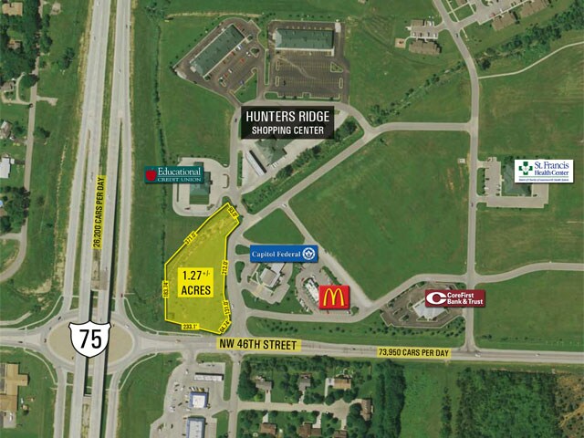
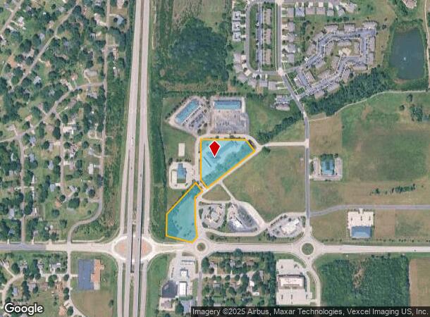
4700 Nw Hunters Ridge Cir
Topeka, KS
Meadowlark Square Sub #2
027-35-0-30-01-002-090
MEADOWLARK SQUARE SUB #2 , BLOCK A , LOT 3 + , BLK A LOT 3 MEADOWLARK SQUARE #2 & BLK A LOTS 1-2 THE RIDGE SUB SECTION 35 TOWNSHIP 10 RANGE 15
Storebuilding
Shawnee
X
Kansas
20177C0089E
3
2024
4.92 AC
2025
Topeka
003402
Kansas City
10,930 SF
DEMOGRAPHICS near 4700 Nw Hunters Ridge Cir
1 Mile
3 Mile
5 Mile
2024 Total Population
3,125
8,472
23,929
2029 Population
3,047
8,274
23,604
Pop Growth 2024-2029
(2.50%)
(2.34%)
(1.36%)
Average Age
41
42
42
2024 Total Households
1,157
3,178
9,707
HH Growth 2024-2029
(2.59%)
(2.42%)
(1.37%)
Median Household Inc
$96,058
$91,080
$67,867
Avg Household Size
2.70
2.60
2.40
2024 Avg HH Vehicles
3.00
3.00
2.00
Median Home Value
$181,304
$186,084
$164,473
Median Year Built
1990
1980
1974
Nearby Places
- Restaurants
- Banks
- Shops
- Fitness
- Groceries
PUBLIC TRANSPORTATION
COMMUTER RAIL
DRIVE
WALK
Distance
13 min
9.0 mi
Nearby Properties
Address
Land Use
TOTAL SIZE
Lot Size
Zoning
Address
Land Use
TOTAL SIZE
Lot Size
Zoning
174,115 SF
61.82 AC
RR1
Address
Land Use
TOTAL SIZE
Lot Size
Zoning
129,425 SF
96.26 AC
R1
Address
Land Use
TOTAL SIZE
Lot Size
Zoning
39,790 SF
3.76 AC
PUD
Address
Land Use
TOTAL SIZE
Lot Size
Zoning
64,318 SF
10.17 AC
RR1
Address
Land Use
TOTAL SIZE
Lot Size
Zoning
20,304 SF
13.48 AC
RR1
Address
Land Use
TOTAL SIZE
Lot Size
Zoning
30,175 SF
7.30 AC
RA1
Address
Land Use
TOTAL SIZE
Lot Size
Zoning
9,588 SF
32.94 AC
RR1
Address
Land Use
TOTAL SIZE
Lot Size
Zoning
29.24 AC
I2
Address
Land Use
TOTAL SIZE
Lot Size
Zoning
18,595 SF
9.19 AC
RR1
Address
Land Use
TOTAL SIZE
Lot Size
Zoning
696,548 SF
63.57 AC
I2
Address
Land Use
TOTAL SIZE
Lot Size
Zoning
90,463 SF
3.55 AC
I2
Address
Land Use
TOTAL SIZE
Lot Size
Zoning
9,330 SF
8.32 AC
OI2,PUD
Address
Land Use
TOTAL SIZE
Lot Size
Zoning
186,100 SF
19.95 AC
I2
Address
Land Use
TOTAL SIZE
Lot Size
Zoning
21,482 SF
16.64 AC
PUD,RR1
Address
Land Use
TOTAL SIZE
Lot Size
Zoning
12,175 SF
3.78 AC
RA1
Address
Land Use
TOTAL SIZE
Lot Size
Zoning
73,600 SF
5.36 AC
PUD,I1
Address
Land Use
TOTAL SIZE
Lot Size
Zoning
19,940 SF
6.79 AC
PUD,RR1
Address
Land Use
TOTAL SIZE
Lot Size
Zoning
34,646 SF
18.43 AC
I2
Address
Land Use
TOTAL SIZE
Lot Size
Zoning
9,324 SF
21.59 AC
RA1
Address
Land Use
TOTAL SIZE
Lot Size
Zoning
8,100 SF
22.28 AC
RR1
Address
Land Use
TOTAL SIZE
Lot Size
Zoning
9,727 SF
4.17 AC
RR1
Address
Land Use
TOTAL SIZE
Lot Size
Zoning
41,560 SF
10 AC
R1
Address
Land Use
TOTAL SIZE
Lot Size
Zoning
58,819 SF
15.18 AC
PUD
Address
Land Use
TOTAL SIZE
Lot Size
Zoning
6,040 SF
2.42 AC
RR1
Address
Land Use
TOTAL SIZE
Lot Size
Zoning
32,430 SF
3.97 AC
I2
Address
Land Use
TOTAL SIZE
Lot Size
Zoning
4,941 SF
16.48 AC
RR1
Address
Land Use
TOTAL SIZE
Lot Size
Zoning
15,000 SF
3.59 AC
I2
Address
Land Use
TOTAL SIZE
Lot Size
Zoning
40,000 SF
3.21 AC
PUD,I1
Address
Land Use
TOTAL SIZE
Lot Size
Zoning
10,417 SF
1.39 AC
C2
Address
Land Use
TOTAL SIZE
Lot Size
Zoning
12.54 AC
I2
The World's #1 Commercial Real Estate Marketplace
Connect with us
© 2025 CoStar Group
The information above has been obtained from sources believed reliable. While we do not doubt its accuracy we have not verified it and make no guarantee, warranty or representation about it. It is your responsibility to independently confirm its accuracy and completeness. Any projections, opinions, assumptions, or estimates used are for example only and do not represent the current or future performance of the property. The value of this transaction to you depends on tax and other factors which should be evaluated by your tax, financial, and legal advisors. You and your advisors should conduct a careful, independent investigation of the property to determine to your satisfaction the suitability of the property for your needs.