Property Record
4700 Parallel Pky, Kansas City, KS 66104
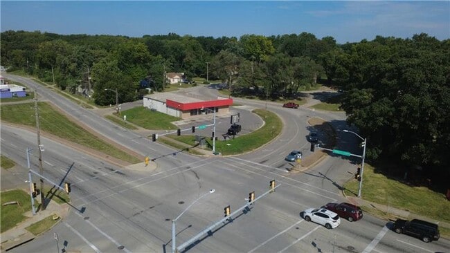
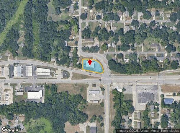
This Property Is For Sale
NEARBY LISTINGS FOR SALE OR LEASE
Property Detail
4700 Parallel Pky
Kansas City, MO-KS
Riceland
914266
9142, S36, T10, R24, ACRES 0.62, 8F1,8F1A BEG SW COR L18 RICELAND SUB, N77W-53.19 TO TOB; N77W-195.29, N104.54, E85.16, SELY ON CUR TO RT 206.04, S60 W-30TPOB 0.54AC 2545-554
Storebuilding
Wyandotte
X
Kansas
29095C0125G
18
2024
0.53 AC
2024
Kansas City KS
044400
Kansas City
4,941 SF
DEMOGRAPHICS near 4700 Parallel Pky
1 Mile
3 Mile
5 Mile
2024 Total Population
9,335
56,650
119,183
2029 Population
9,053
55,595
117,396
Pop Growth 2024-2029
(3.02%)
(1.86%)
(1.50%)
Average Age
35
36
36
2024 Total Households
3,140
19,440
42,016
HH Growth 2024-2029
(3.09%)
(1.91%)
(1.49%)
Median Household Inc
$55,968
$50,091
$50,568
Avg Household Size
2.80
2.80
2.70
2024 Avg HH Vehicles
2.00
2.00
2.00
Median Home Value
$113,703
$106,463
$130,574
Median Year Built
1955
1954
1958
Nearby Places
- Restaurants
- Banks
- Shops
- Fitness
- Groceries
PUBLIC TRANSPORTATION
COMMUTER RAIL
DRIVE
WALK
Distance
16 min
9.1 mi
AIRPORT
Kansas City International
DRIVE
WALK
Distance
Kansas City International
25 min
18.4 mi
Nearby Properties
Address
Land Use
TOTAL SIZE
Lot Size
Zoning
Address
Land Use
TOTAL SIZE
Lot Size
Zoning
347,991 SF
51.92 AC
1KMC
Address
Land Use
TOTAL SIZE
Lot Size
Zoning
264,254 SF
56.62 AC
KR1
Address
Land Use
TOTAL SIZE
Lot Size
Zoning
542,696 SF
28.12 AC
Address
Land Use
TOTAL SIZE
Lot Size
Zoning
346,224 SF
28.44 AC
Address
Land Use
TOTAL SIZE
Lot Size
Zoning
407,936 SF
37.46 AC
1
Address
Land Use
TOTAL SIZE
Lot Size
Zoning
88,396 SF
23.79 AC
Address
Land Use
TOTAL SIZE
Lot Size
Zoning
241,816 SF
20.03 AC
Address
Land Use
TOTAL SIZE
Lot Size
Zoning
139,499 SF
20.51 AC
KR1B
Address
Land Use
TOTAL SIZE
Lot Size
Zoning
71,326 SF
6.31 AC
KR1
Address
Land Use
TOTAL SIZE
Lot Size
Zoning
75,309 SF
19.40 AC
KR1
Address
Land Use
TOTAL SIZE
Lot Size
Zoning
54,578 SF
12.01 AC
KR1
Address
Land Use
TOTAL SIZE
Lot Size
Zoning
383,232 SF
15.93 AC
LU1
Address
Land Use
TOTAL SIZE
Lot Size
Zoning
52,374 SF
2.88 AC
KRP5
Address
Land Use
TOTAL SIZE
Lot Size
Zoning
158,011 SF
26.66 AC
Address
Land Use
TOTAL SIZE
Lot Size
Zoning
122,217 SF
23.87 AC
KR2
Address
Land Use
TOTAL SIZE
Lot Size
Zoning
39,641 SF
23.60 AC
Address
Land Use
TOTAL SIZE
Lot Size
Zoning
207,491 SF
616.94 AC
KR1
Address
Land Use
TOTAL SIZE
Lot Size
Zoning
36,841 SF
7.72 AC
KRP5
Address
Land Use
TOTAL SIZE
Lot Size
Zoning
132,724 SF
20.84 AC
KC1
Address
Land Use
TOTAL SIZE
Lot Size
Zoning
45,968 SF
2.58 AC
KR2
Address
Land Use
TOTAL SIZE
Lot Size
Zoning
1,032,141 SF
45.80 AC
LU1
Address
Land Use
TOTAL SIZE
Lot Size
Zoning
36,576 SF
4.46 AC
Address
Land Use
TOTAL SIZE
Lot Size
Zoning
53,029 SF
6.50 AC
KR1B
Address
Land Use
TOTAL SIZE
Lot Size
Zoning
39,588 SF
16.33 AC
KR1
Address
Land Use
TOTAL SIZE
Lot Size
Zoning
56,072 SF
2.35 AC
Address
Land Use
TOTAL SIZE
Lot Size
Zoning
56,406 SF
16.39 AC
KR2
Address
Land Use
TOTAL SIZE
Lot Size
Zoning
41,904 SF
2.48 AC
Address
Land Use
TOTAL SIZE
Lot Size
Zoning
31,185 SF
4.72 AC
KC1
Address
Land Use
TOTAL SIZE
Lot Size
Zoning
9,700 SF
3.30 AC
KRP5
Address
Land Use
TOTAL SIZE
Lot Size
Zoning
513,300 SF
23.85 AC
KM3
The World's #1 Commercial Real Estate Marketplace
Connect with us
© 2025 CoStar Group
The information above has been obtained from sources believed reliable. While we do not doubt its accuracy we have not verified it and make no guarantee, warranty or representation about it. It is your responsibility to independently confirm its accuracy and completeness. Any projections, opinions, assumptions, or estimates used are for example only and do not represent the current or future performance of the property. The value of this transaction to you depends on tax and other factors which should be evaluated by your tax, financial, and legal advisors. You and your advisors should conduct a careful, independent investigation of the property to determine to your satisfaction the suitability of the property for your needs.