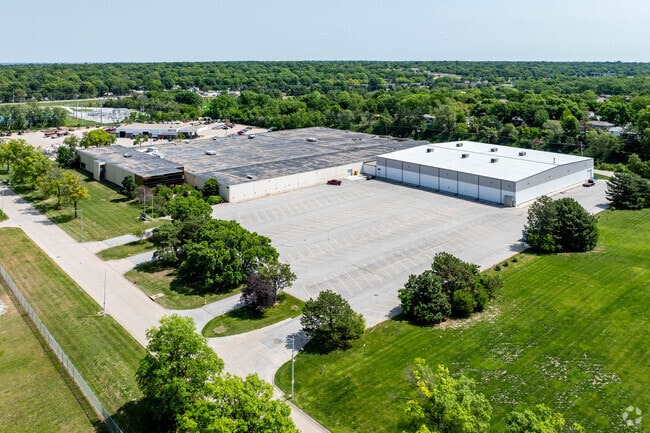
Property Record
4700 S 19Th St, Lincoln, NE 68512

Current Lease Availabilities
NEARBY LISTINGS FOR SALE OR LEASE
Property Detail
4700 S 19Th St
Lincoln, NE
Lincoln Industrial Park
09-12-108-001-000
LINCOLN INDUSTRIAL PARK, BLOCK 5, LOT 1 - 5, & S1/2 VAC CENTER PARK RD ADJ
Commercialnec
Lancaster
X
Nebraska
31109C0315F
1-5
2024
10.71 AC
2025
Far South
003605
Lincoln
199,363 SF
DEMOGRAPHICS near 4700 S 19Th St
1 Mile
3 Mile
5 Mile
2024 Total Population
9,198
93,367
187,343
2029 Population
9,488
96,419
193,877
Pop Growth 2024-2029
+ 3.15%
+ 3.27%
+ 3.49%
Average Age
40
39
38
2024 Total Households
3,995
40,298
78,088
HH Growth 2024-2029
+ 3.23%
+ 3.44%
+ 3.67%
Median Household Inc
$71,073
$64,284
$64,782
Avg Household Size
2.30
2.20
2.30
2024 Avg HH Vehicles
2.00
2.00
2.00
Median Home Value
$235,604
$239,339
$244,456
Median Year Built
1974
1973
1977
Nearby Places
Map Layers
Map Styles
 Street
 Aerial
- Restaurants
- Banks
- Shops
- Fitness
- Groceries
PUBLIC TRANSPORTATION
COMMUTER RAIL
DRIVE
WALK
Distance
11 min
4.6 mi
AIRPORT
Lincoln
DRIVE
WALK
Distance
Lincoln
17 min
9.3 mi
Nearby Properties
Address
Land Use
TOTAL SIZE
Lot Size
Zoning
Address
Land Use
TOTAL SIZE
Lot Size
Zoning
684,598 SF
21.16 AC
B3
Address
Land Use
TOTAL SIZE
Lot Size
Zoning
329,069 SF
30 AC
R6
Address
Land Use
TOTAL SIZE
Lot Size
Zoning
48,378 SF
9.53 AC
R5
Address
Land Use
TOTAL SIZE
Lot Size
Zoning
213,738 SF
14.97 AC
B5
Address
Land Use
TOTAL SIZE
Lot Size
Zoning
126,172 SF
5.46 AC
B2
Address
Land Use
TOTAL SIZE
Lot Size
Zoning
234,103 SF
13.56 AC
R2
Address
Land Use
TOTAL SIZE
Lot Size
Zoning
35,972 SF
10.13 AC
O3
Address
Land Use
TOTAL SIZE
Lot Size
Zoning
44,957 SF
7.93 AC
R4
Address
Land Use
TOTAL SIZE
Lot Size
Zoning
40,602 SF
7.07 AC
B2
Address
Land Use
TOTAL SIZE
Lot Size
Zoning
11.90 AC
P
Address
Land Use
TOTAL SIZE
Lot Size
Zoning
169,890 SF
3.05 AC
O3
Address
Land Use
TOTAL SIZE
Lot Size
Zoning
32,854 SF
22.09 AC
NULL
Address
Land Use
TOTAL SIZE
Lot Size
Zoning
33,983 SF
23.08 AC
R4
Address
Land Use
TOTAL SIZE
Lot Size
Zoning
22,324 SF
16.59 AC
NULL
Address
Land Use
TOTAL SIZE
Lot Size
Zoning
14,637 SF
18.90 AC
NULL
Address
Land Use
TOTAL SIZE
Lot Size
Zoning
43,921 SF
15.65 AC
B2
Address
Land Use
TOTAL SIZE
Lot Size
Zoning
16,284 SF
8.77 AC
NULL
Address
Land Use
TOTAL SIZE
Lot Size
Zoning
39,968 SF
13.41 AC
NULL
Address
Land Use
TOTAL SIZE
Lot Size
Zoning
131,049 SF
78.38 AC
P
Address
Land Use
TOTAL SIZE
Lot Size
Zoning
63,298 SF
10.15 AC
R1
Address
Land Use
TOTAL SIZE
Lot Size
Zoning
78,993 SF
3.56 AC
H4
Address
Land Use
TOTAL SIZE
Lot Size
Zoning
68,764 SF
10.45 AC
R3
Address
Land Use
TOTAL SIZE
Lot Size
Zoning
101,990 SF
5.38 AC
R4
Address
Land Use
TOTAL SIZE
Lot Size
Zoning
111,178 SF
15.53 AC
O3
Address
Land Use
TOTAL SIZE
Lot Size
Zoning
372,652 SF
24.70 AC
I2
Address
Land Use
TOTAL SIZE
Lot Size
Zoning
149,431 SF
13.38 AC
O3
Address
Land Use
TOTAL SIZE
Lot Size
Zoning
70,676 SF
26.52 AC
P
Address
Land Use
TOTAL SIZE
Lot Size
Zoning
45,057 SF
37.07 AC
NULL
Address
Land Use
TOTAL SIZE
Lot Size
Zoning
175,311 SF
52.45 AC
I1
Address
Land Use
TOTAL SIZE
Lot Size
Zoning
32,942 SF
8.94 AC
R1
The World's #1 Commercial Real Estate Marketplace
Connect with us
© 2026 CoStar Group
The information above has been obtained from sources believed reliable. While we do not doubt its accuracy we have not verified it and make no guarantee, warranty or representation about it. It is your responsibility to independently confirm its accuracy and completeness. Any projections, opinions, assumptions, or estimates used are for example only and do not represent the current or future performance of the property. The value of this transaction to you depends on tax and other factors which should be evaluated by your tax, financial, and legal advisors. You and your advisors should conduct a careful, independent investigation of the property to determine to your satisfaction the suitability of the property for your needs.