Property Record
4700 Wenda St, Houston, TX 77033


NEARBY LISTINGS FOR SALE OR LEASE
Property Detail
4700 Wenda St
1220790000001
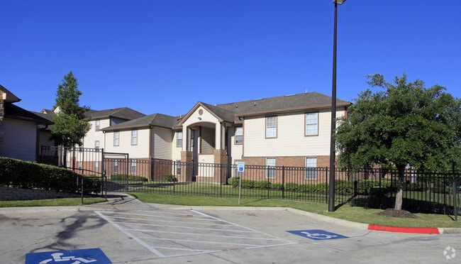
Cullen Park Apts
Apartment
BLDGS 1 THRU 15 CULLEN PARK APTS
X
Harris
48201C0890M
Texas
2024
14 AC
2025
Sunnyside
331800
Houston
258,823 SF
Houston-Pasadena-The Woodlands, TX
DEMOGRAPHICS near 4700 Wenda St
1 Mile
3 Mile
5 Mile
2024 Total Population
13,816
97,020
278,412
2029 Population
14,259
100,308
287,164
Pop Growth 2024-2029
+ 3.21%
+ 3.39%
+ 3.14%
Average Age
38
37
36
2024 Total Households
5,115
34,650
103,125
HH Growth 2024-2029
+ 3.11%
+ 3.39%
+ 3.29%
Median Household Inc
$33,714
$38,516
$48,140
Avg Household Size
2.60
2.70
2.50
2024 Avg HH Vehicles
1.00
2.00
2.00
Median Home Value
$82,895
$112,118
$163,625
Median Year Built
1964
1969
1980
Nearby Places
Map Layers
Map Styles
 Street
 Aerial
- Restaurants
- Banks
- Shops
- Fitness
- Groceries
PUBLIC TRANSPORTATION
AIRPORT
William P Hobby
DRIVE
WALK
Distance
William P Hobby
17 min
7.5 mi
George Bush Intcntl/Houston
DRIVE
WALK
Distance
George Bush Intcntl/Houston
39 min
27.7 mi
Freight Ports
Port of Houston
DRIVE
WALK
Distance
Port of Houston
20 min
11.0 mi
Nearby Properties
Address
Land Use
TOTAL SIZE
Lot Size
Zoning
Address
Land Use
TOTAL SIZE
Lot Size
Zoning
651,551 SF
52.18 AC
Address
Land Use
TOTAL SIZE
Lot Size
Zoning
413,336 SF
24.57 AC
Address
Land Use
TOTAL SIZE
Lot Size
Zoning
273,854 SF
9.57 AC
Address
Land Use
TOTAL SIZE
Lot Size
Zoning
217,822 SF
8.12 AC
Address
Land Use
TOTAL SIZE
Lot Size
Zoning
389,108 SF
37.39 AC
Address
Land Use
TOTAL SIZE
Lot Size
Zoning
270,803 SF
8.26 AC
Address
Land Use
TOTAL SIZE
Lot Size
Zoning
268,425 SF
17.47 AC
Address
Land Use
TOTAL SIZE
Lot Size
Zoning
295,210 SF
13.68 AC
Address
Land Use
TOTAL SIZE
Lot Size
Zoning
231,696 SF
Address
Land Use
TOTAL SIZE
Lot Size
Zoning
264,384 SF
13.76 AC
Address
Land Use
TOTAL SIZE
Lot Size
Zoning
190,172 SF
14.71 AC
Address
Land Use
TOTAL SIZE
Lot Size
Zoning
239,458 SF
15.57 AC
Address
Land Use
TOTAL SIZE
Lot Size
Zoning
210,476 SF
9.60 AC
Address
Land Use
TOTAL SIZE
Lot Size
Zoning
193,500 SF
9.46 AC
Address
Land Use
TOTAL SIZE
Lot Size
Zoning
157,387 SF
6.38 AC
Address
Land Use
TOTAL SIZE
Lot Size
Zoning
367,096 SF
15.76 AC
Address
Land Use
TOTAL SIZE
Lot Size
Zoning
10.43 AC
Address
Land Use
TOTAL SIZE
Lot Size
Zoning
114,520 SF
2.19 AC
Address
Land Use
TOTAL SIZE
Lot Size
Zoning
168,937 SF
5.92 AC
Address
Land Use
TOTAL SIZE
Lot Size
Zoning
433,760 SF
52.70 AC
Address
Land Use
TOTAL SIZE
Lot Size
Zoning
210,870 SF
13.07 AC
Address
Land Use
TOTAL SIZE
Lot Size
Zoning
109,807 SF
10.28 AC
Address
Land Use
TOTAL SIZE
Lot Size
Zoning
147,146 SF
6.95 AC
Address
Land Use
TOTAL SIZE
Lot Size
Zoning
100,458 SF
8.54 AC
Address
Land Use
TOTAL SIZE
Lot Size
Zoning
66,122 SF
5.62 AC
Address
Land Use
TOTAL SIZE
Lot Size
Zoning
172,436 SF
33.98 AC
Address
Land Use
TOTAL SIZE
Lot Size
Zoning
288,775 SF
13.99 AC
Address
Land Use
TOTAL SIZE
Lot Size
Zoning
233,608 SF
13.45 AC
Address
Land Use
TOTAL SIZE
Lot Size
Zoning
133,475 SF
11.52 AC
Address
Land Use
TOTAL SIZE
Lot Size
Zoning
304,806 SF
15.60 AC
The World's #1 Commercial Real Estate Marketplace
Connect with us
© 2026 CoStar Group
The information above has been obtained from sources believed reliable. While we do not doubt its accuracy we have not verified it and make no guarantee, warranty or representation about it. It is your responsibility to independently confirm its accuracy and completeness. Any projections, opinions, assumptions, or estimates used are for example only and do not represent the current or future performance of the property. The value of this transaction to you depends on tax and other factors which should be evaluated by your tax, financial, and legal advisors. You and your advisors should conduct a careful, independent investigation of the property to determine to your satisfaction the suitability of the property for your needs.