Property Record
4701 Minnesota Ave Ne, Washington, DC 20019
Current Lease Availabilities
NEARBY LISTINGS FOR SALE OR LEASE
Property Detail
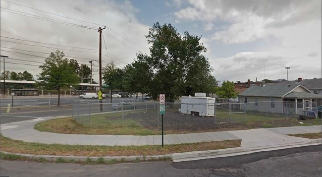
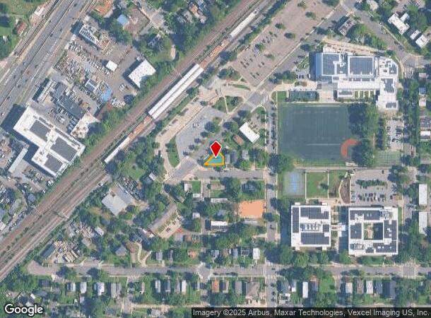
4701 Minnesota Ave Ne
Washington-Arlington-Alexandria, DC-VA-MD-WV
Deanwood
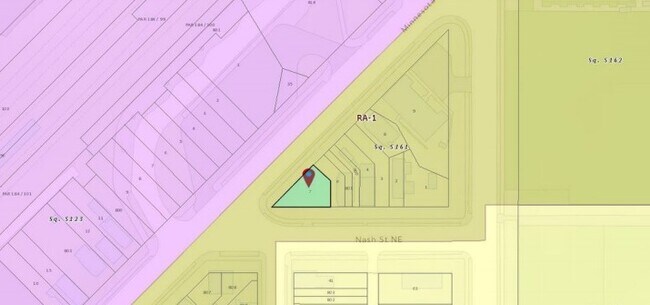
5161-0007
SQUARE 5161 LOT 0007 NBHD: DEANWOOD
Vacantlandnec
District of Columbia
X
District of Columbia
24033C0141E
7
2025
0.06 AC
2025
Northeast
007806
Washington, DC
DEMOGRAPHICS near 4701 Minnesota Ave Ne
1 Mile
3 Mile
5 Mile
2024 Total Population
21,820
185,158
599,702
2029 Population
20,349
174,275
568,255
Pop Growth 2024-2029
(6.74%)
(5.88%)
(5.24%)
Average Age
38
39
37
2024 Total Households
8,043
71,123
246,720
HH Growth 2024-2029
(7.56%)
(6.71%)
(5.98%)
Median Household Inc
$47,935
$64,438
$77,237
Avg Household Size
2.50
2.50
2.30
2024 Avg HH Vehicles
1.00
1.00
1.00
Median Home Value
$386,939
$391,660
$425,677
Median Year Built
1960
1957
1965
Nearby Places
- Restaurants
- Banks
- Shops
- Fitness
- Groceries
PUBLIC TRANSPORTATION
TRANSIT/SUBWAY
Deanwood (Orange Line - Washington Metropolitan Area Transit Authority Metrorail (Metrorail))
DRIVE
WALK
Distance
Deanwood (Orange Line - Washington Metropolitan Area Transit Authority Metrorail (Metrorail))
0 min
5 min
0.1 mi
COMMUTER RAIL
Lead (Fredericksburg Line - Virginia Railway Express, Manassas Line - Virginia Railway Express)
DRIVE
WALK
Distance
Lead (Fredericksburg Line - Virginia Railway Express, Manassas Line - Virginia Railway Express)
8 min
4.4 mi
Riverdale (CAMDEN - WASHINGTON - Maryland Area Regional Commuter Trains (The MARC), Camden Line - Maryland Area Regional Commuter Trains (The MARC))
DRIVE
WALK
Distance
Riverdale (CAMDEN - WASHINGTON - Maryland Area Regional Commuter Trains (The MARC), Camden Line - Maryland Area Regional Commuter Trains (The MARC))
10 min
4.6 mi
AIRPORT
Ronald Reagan Washington Ntl
DRIVE
WALK
Distance
Ronald Reagan Washington Ntl
19 min
10.6 mi
Baltimore/Washington International Thurgood Marshall
DRIVE
WALK
Distance
Baltimore/Washington International Thurgood Marshall
39 min
26.8 mi
Washington Dulles International
DRIVE
WALK
Distance
Washington Dulles International
54 min
33.3 mi
Freight Ports
Port of Baltimore
DRIVE
WALK
Distance
Port of Baltimore
49 min
33.4 mi
Nearby Properties
Address
Land Use
TOTAL SIZE
Lot Size
Zoning
Address
Land Use
TOTAL SIZE
Lot Size
Zoning
58,289 SF
418.97 AC
MU-4;PDR-1
Address
Land Use
TOTAL SIZE
Lot Size
Zoning
21.28 AC
GOV
Address
Land Use
TOTAL SIZE
Lot Size
Zoning
169.85 AC
R-2;RA-1;U
Address
Land Use
TOTAL SIZE
Lot Size
Zoning
36.52 AC
HE-2;HE-3;
Address
Land Use
TOTAL SIZE
Lot Size
Zoning
236,535 SF
12.54 AC
R-2
Address
Land Use
TOTAL SIZE
Lot Size
Zoning
944,105 SF
23.09 AC
CGO
Address
Land Use
TOTAL SIZE
Lot Size
Zoning
241,725 SF
4.71 AC
MU-7B;PDR-
Address
Land Use
TOTAL SIZE
Lot Size
Zoning
62.03 AC
UNZONED
Address
Land Use
TOTAL SIZE
Lot Size
Zoning
229,238 SF
1.51 AC
MU-7B
Address
Land Use
TOTAL SIZE
Lot Size
Zoning
259,000 SF
1.91 AC
MU-7B
Address
Land Use
TOTAL SIZE
Lot Size
Zoning
821,240 SF
48.32 AC
IH
Address
Land Use
TOTAL SIZE
Lot Size
Zoning
192,440 SF
7.67 AC
R-2;RA-1
Address
Land Use
TOTAL SIZE
Lot Size
Zoning
0.30 AC
PDR-2
Address
Land Use
TOTAL SIZE
Lot Size
Zoning
270,109 SF
17.63 AC
PDR-1;PDR-
Address
Land Use
TOTAL SIZE
Lot Size
Zoning
107,130 SF
2.98 AC
R-2;RA-1
Address
Land Use
TOTAL SIZE
Lot Size
Zoning
419,689 SF
66.84 AC
PDR-1;PDR-
Address
Land Use
TOTAL SIZE
Lot Size
Zoning
308,000 SF
1.76 AC
HE-1;HE-2
Address
Land Use
TOTAL SIZE
Lot Size
Zoning
132,000 SF
RA-1
Address
Land Use
TOTAL SIZE
Lot Size
Zoning
230,000 SF
4.25 AC
MU-5A;RA-4
Address
Land Use
TOTAL SIZE
Lot Size
Zoning
262,236 SF
15.26 AC
MU-8B
Address
Land Use
TOTAL SIZE
Lot Size
Zoning
379,168 SF
18.94 AC
RMF20
Address
Land Use
TOTAL SIZE
Lot Size
Zoning
181,530 SF
4.72 AC
R-2
Address
Land Use
TOTAL SIZE
Lot Size
Zoning
62,797 SF
0.55 AC
R2
Address
Land Use
TOTAL SIZE
Lot Size
Zoning
88,437 SF
3 AC
RF-1
Address
Land Use
TOTAL SIZE
Lot Size
Zoning
157,680 SF
0.60 AC
MU-7B
Address
Land Use
TOTAL SIZE
Lot Size
Zoning
92,511 SF
1.48 AC
RA-1
Address
Land Use
TOTAL SIZE
Lot Size
Zoning
25.33 AC
UNZONED
Address
Land Use
TOTAL SIZE
Lot Size
Zoning
255,208 SF
2.98 AC
MU-7B
Address
Land Use
TOTAL SIZE
Lot Size
Zoning
441,127 SF
2.72 AC
RF-1
Address
Land Use
TOTAL SIZE
Lot Size
Zoning
99,540 SF
3.81 AC
HE-1;HE-2
The World's #1 Commercial Real Estate Marketplace
Connect with us
© 2025 CoStar Group
The information above has been obtained from sources believed reliable. While we do not doubt its accuracy we have not verified it and make no guarantee, warranty or representation about it. It is your responsibility to independently confirm its accuracy and completeness. Any projections, opinions, assumptions, or estimates used are for example only and do not represent the current or future performance of the property. The value of this transaction to you depends on tax and other factors which should be evaluated by your tax, financial, and legal advisors. You and your advisors should conduct a careful, independent investigation of the property to determine to your satisfaction the suitability of the property for your needs.