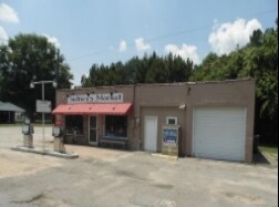
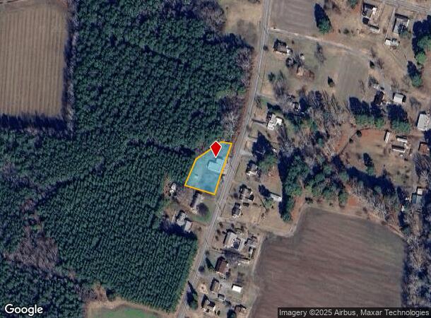
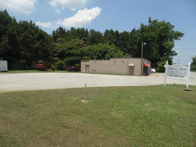
Property Record
4701 Nc Highway 35 Hwy, Conway, NC 27820
NEARBY LISTINGS FOR SALE OR LEASE
-
-
View all Conway listings for sale on LoopNet.com
Property Detail
4701 Nc Highway 35 Hwy
03-00492
STATION
Conveniencestore
Northampton
X
North Carolina
3720590600J
0.58 AC
2025
North Carolina Northeast Area
2025
Other Market Areas
920103
Roanoke Rapids, NC
2,232 SF
DEMOGRAPHICS near 4701 Nc Highway 35 Hwy
1 Mile
3 Mile
5 Mile
2024 Total Population
209
1,497
3,012
2029 Population
201
1,428
2,876
Pop Growth 2024-2029
(3.83%)
(4.61%)
(4.52%)
Average Age
46
45
45
2024 Total Households
91
656
1,324
HH Growth 2024-2029
(4.40%)
(4.73%)
(4.53%)
Median Household Inc
$51,613
$50,698
$50,669
Avg Household Size
2.30
2.20
2.20
2024 Avg HH Vehicles
2.00
2.00
2.00
Median Home Value
$117,647
$122,704
$119,413
Median Year Built
1953
1959
1965
Nearby Places
Map Layers
Map Styles
 Street
 Aerial
- Restaurants
- Banks
- Shops
- Fitness
- Groceries
SALE & LEASE HISTORY
LISTING DATE
SALE/LEASE

Jul 30, 2018
For Sale
Feb 18, 2022
For Sale
Nearby Properties
Address
Land Use
TOTAL SIZE
Lot Size
Zoning
Address
Land Use
TOTAL SIZE
Lot Size
Zoning
552 SF
13.67 AC
Address
Land Use
TOTAL SIZE
Lot Size
Zoning
1,440 SF
79.54 AC
HI
Address
Land Use
TOTAL SIZE
Lot Size
Zoning
302 SF
1.15 AC
AR
Address
Land Use
TOTAL SIZE
Lot Size
Zoning
69.79 AC
AR
Address
Land Use
TOTAL SIZE
Lot Size
Zoning
10,792 SF
1.93 AC
Address
Land Use
TOTAL SIZE
Lot Size
Zoning
5,304 SF
5.10 AC
Address
Land Use
TOTAL SIZE
Lot Size
Zoning
8,320 SF
1.02 AC
Address
Land Use
TOTAL SIZE
Lot Size
Zoning
8,924 SF
1.48 AC
Address
Land Use
TOTAL SIZE
Lot Size
Zoning
172 SF
4.71 AC
Address
Land Use
TOTAL SIZE
Lot Size
Zoning
13.71 AC
AR
Address
Land Use
TOTAL SIZE
Lot Size
Zoning
1,320 SF
1.63 AC
AR
Address
Land Use
TOTAL SIZE
Lot Size
Zoning
7,064 SF
2.02 AC
AR
Address
Land Use
TOTAL SIZE
Lot Size
Zoning
6,681 SF
0.89 AC
AR
Address
Land Use
TOTAL SIZE
Lot Size
Zoning
6,974 SF
2.15 AC
AR
Address
Land Use
TOTAL SIZE
Lot Size
Zoning
3,275 SF
3.95 AC
AR
Address
Land Use
TOTAL SIZE
Lot Size
Zoning
2,658 SF
0.90 AC
AR
Address
Land Use
TOTAL SIZE
Lot Size
Zoning
6,000 SF
2.50 AC
Address
Land Use
TOTAL SIZE
Lot Size
Zoning
1,326 SF
1.90 AC
AR
Address
Land Use
TOTAL SIZE
Lot Size
Zoning
1,518 SF
74.58 AC
AR
Address
Land Use
TOTAL SIZE
Lot Size
Zoning
660 SF
0.47 AC
Address
Land Use
TOTAL SIZE
Lot Size
Zoning
11.34 AC
AR
Address
Land Use
TOTAL SIZE
Lot Size
Zoning
2,208 SF
0.75 AC
Address
Land Use
TOTAL SIZE
Lot Size
Zoning
2,457 SF
2.13 AC
Address
Land Use
TOTAL SIZE
Lot Size
Zoning
7,400 SF
2.10 AC
Address
Land Use
TOTAL SIZE
Lot Size
Zoning
2,458 SF
0.51 AC
Address
Land Use
TOTAL SIZE
Lot Size
Zoning
1,626 SF
1 AC
AR
Address
Land Use
TOTAL SIZE
Lot Size
Zoning
3,000 SF
7.63 AC
HB
Address
Land Use
TOTAL SIZE
Lot Size
Zoning
1,240 SF
1.80 AC
Address
Land Use
TOTAL SIZE
Lot Size
Zoning
1,605 SF
1.09 AC
Address
Land Use
TOTAL SIZE
Lot Size
Zoning
3,880 SF
2.29 AC
AR
The World's #1 Commercial Real Estate Marketplace
Connect with us
© 2026 CoStar Group
The information above has been obtained from sources believed reliable. While we do not doubt its accuracy we have not verified it and make no guarantee, warranty or representation about it. It is your responsibility to independently confirm its accuracy and completeness. Any projections, opinions, assumptions, or estimates used are for example only and do not represent the current or future performance of the property. The value of this transaction to you depends on tax and other factors which should be evaluated by your tax, financial, and legal advisors. You and your advisors should conduct a careful, independent investigation of the property to determine to your satisfaction the suitability of the property for your needs.