Property Record
4701 Owens Way, Prince George, VA 23875
Current Lease Availabilities
NEARBY LISTINGS FOR SALE OR LEASE
Property Detail
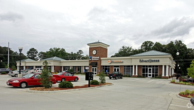
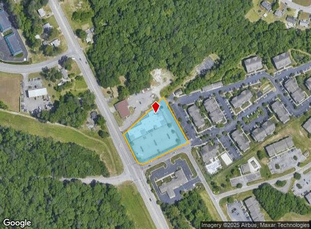
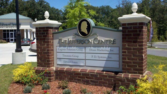
4701 Owens Way
12D(03)00-001-0
LT:1 BLK: SEC:1; SUB:BAILEYS RIDGE COMMERCIAL PARK; ACRES:2.016;
Officebuilding
Prince George
X
Virginia
51041C0365E
1
2024
2.02 AC
2025
Prince George
850301
Richmond VA
18,007 SF
Richmond, VA
DEMOGRAPHICS near 4701 Owens Way
1 Mile
3 Mile
5 Mile
2024 Total Population
3,681
34,826
74,186
2029 Population
3,709
35,041
74,588
Pop Growth 2024-2029
+ 0.76%
+ 0.62%
+ 0.54%
Average Age
38
35
38
2024 Total Households
1,497
11,063
26,204
HH Growth 2024-2029
+ 0.80%
+ 0.39%
+ 0.40%
Median Household Inc
$45,128
$57,886
$57,322
Avg Household Size
2.40
2.60
2.40
2024 Avg HH Vehicles
2.00
2.00
2.00
Median Home Value
$215,278
$161,285
$175,644
Median Year Built
1986
1983
1975
Nearby Places
Map Layers
Map Styles
 Street
 Aerial
- Restaurants
- Banks
- Shops
- Fitness
- Groceries
PUBLIC TRANSPORTATION
COMMUTER RAIL
Petersburg Amtrak Station (Carolinian - Amtrak, Northeast Regional - Amtrak, Palmetto - Amtrak, Silver Meteor - Amtrak, Silver Star - Amtrak)
DRIVE
WALK
Distance
Petersburg Amtrak Station (Carolinian - Amtrak, Northeast Regional - Amtrak, Palmetto - Amtrak, Silver Meteor - Amtrak, Silver Star - Amtrak)
12 min
8.1 mi
AIRPORT
Richmond International
DRIVE
WALK
Distance
Richmond International
32 min
23.8 mi
Freight Ports
Virginia Port Authority - Richmond
DRIVE
WALK
Distance
Virginia Port Authority - Richmond
30 min
21.2 mi
Nearby Properties
Address
Land Use
TOTAL SIZE
Lot Size
Zoning
Address
Land Use
TOTAL SIZE
Lot Size
Zoning
4,762.27 AC
Address
Land Use
TOTAL SIZE
Lot Size
Zoning
177,075 SF
110.41 AC
R2
Address
Land Use
TOTAL SIZE
Lot Size
Zoning
15,435 SF
13.51 AC
11
Address
Land Use
TOTAL SIZE
Lot Size
Zoning
498.93 AC
Address
Land Use
TOTAL SIZE
Lot Size
Zoning
97,040 SF
68.98 AC
RA
Address
Land Use
TOTAL SIZE
Lot Size
Zoning
58,054 SF
14.19 AC
11
Address
Land Use
TOTAL SIZE
Lot Size
Zoning
16 AC
R3
Address
Land Use
TOTAL SIZE
Lot Size
Zoning
76,614 SF
16.16 AC
RA
Address
Land Use
TOTAL SIZE
Lot Size
Zoning
186,558 SF
19.06 AC
11
Address
Land Use
TOTAL SIZE
Lot Size
Zoning
6,284 SF
14.29 AC
11
Address
Land Use
TOTAL SIZE
Lot Size
Zoning
67,161 SF
3.06 AC
B3
Address
Land Use
TOTAL SIZE
Lot Size
Zoning
29,585 SF
5.67 AC
R4
Address
Land Use
TOTAL SIZE
Lot Size
Zoning
95,603 SF
1.99 AC
B4
Address
Land Use
TOTAL SIZE
Lot Size
Zoning
10.78 AC
R4
Address
Land Use
TOTAL SIZE
Lot Size
Zoning
38,832 SF
3.33 AC
B3
Address
Land Use
TOTAL SIZE
Lot Size
Zoning
94,052 SF
4.14 AC
11
Address
Land Use
TOTAL SIZE
Lot Size
Zoning
46,788 SF
1.95 AC
B3
Address
Land Use
TOTAL SIZE
Lot Size
Zoning
73,071 SF
1.42 AC
B4
Address
Land Use
TOTAL SIZE
Lot Size
Zoning
52,342 SF
7.16 AC
B3
Address
Land Use
TOTAL SIZE
Lot Size
Zoning
79,889 SF
16.67 AC
R3
Address
Land Use
TOTAL SIZE
Lot Size
Zoning
25,994 SF
3.75 AC
11
Address
Land Use
TOTAL SIZE
Lot Size
Zoning
37,244 SF
2.62 AC
B3
Address
Land Use
TOTAL SIZE
Lot Size
Zoning
3.65 AC
R4
Address
Land Use
TOTAL SIZE
Lot Size
Zoning
75,410 SF
3.80 AC
11
Address
Land Use
TOTAL SIZE
Lot Size
Zoning
19.50 AC
RA
Address
Land Use
TOTAL SIZE
Lot Size
Zoning
4,400 SF
898.73 AC
I2
Address
Land Use
TOTAL SIZE
Lot Size
Zoning
79,889 SF
8.80 AC
R2
Address
Land Use
TOTAL SIZE
Lot Size
Zoning
33,294 SF
3.14 AC
B3
Address
Land Use
TOTAL SIZE
Lot Size
Zoning
52,572 SF
3.77 AC
B3
Address
Land Use
TOTAL SIZE
Lot Size
Zoning
10,737 SF
1.91 AC
The World's #1 Commercial Real Estate Marketplace
Connect with us
© 2025 CoStar Group
The information above has been obtained from sources believed reliable. While we do not doubt its accuracy we have not verified it and make no guarantee, warranty or representation about it. It is your responsibility to independently confirm its accuracy and completeness. Any projections, opinions, assumptions, or estimates used are for example only and do not represent the current or future performance of the property. The value of this transaction to you depends on tax and other factors which should be evaluated by your tax, financial, and legal advisors. You and your advisors should conduct a careful, independent investigation of the property to determine to your satisfaction the suitability of the property for your needs.