Property Record
4701 S Limit Ave, Sedalia, MO 65301


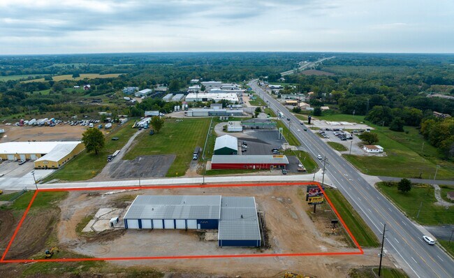
Property Detail
4701 S Limit Ave
Sedalia, MO
BEG 70' E OF NW COR SE SE S 1098.2' FOR BEG S 243.8' E 530' N 243.8' W 530' TO BEG 17 45 21
154017403005000
PETTIS
Commercialnec
Missouri
2025
2.97 AC
2025
Missouri North Area
480300
Other Market Areas
14,120 SF
NEARBY LISTINGS FOR SALE OR LEASE
-
-
View all Sedalia listings for lease on LoopNet.com
DEMOGRAPHICS near 4701 S Limit Ave
1 mile
3 mile
5 mile
2025 Total Population
945
20,598
31,116
2030 Population
969
20,920
31,671
Pop Growth 2025-2030
+ 2.54%
+ 1.56%
+ 1.78%
Average Age
41
39
39
2025 Total Households
356
8,404
12,424
HH Growth 2025-2030
+ 2.81%
+ 1.63%
+ 1.82%
Median Household Inc
$86,298
$58,073
$58,207
Avg Household Size
2.60
2.30
2.40
2025 Avg HH Vehicles
2.00
2.00
2.00
Median Home Value
$236,559
$170,750
$171,598
Median Year Built
1982
1967
1970
Nearby Places
Map Layers
Map Styles
 Street
 Aerial
Layers
 Traffic
 Biking
Places
Listings with unknown addresses are not visible on the map
- Restaurants
- Banks
- Shops
- Fitness
- Groceries
PUBLIC TRANSPORTATION
COMMUTER RAIL
Sedalia Amtrak Station (Lincoln Service Missouri River Runner - Amtrak, Missouri River Runner - Amtrak)
Drive
Walk
Distance
Sedalia Amtrak Station (Lincoln Service Missouri River Runner - Amtrak, Missouri River Runner - Amtrak)
9 min
3.8 mi
Freight Ports
Tulsa Port Of Catoosa
Drive
Walk
Distance
Tulsa Port Of Catoosa
308 min
269.3 mi
SALE & LEASE HISTORY
LISTING DATE
SALE/LEASE

Nov 20, 2024
For Lease
Dec 23, 2024
For Lease
Nearby Properties
Address
Land Use
TOTAL SIZE
Lot Size
Zoning
Address
Land Use
TOTAL SIZE
Lot Size
Zoning
52,605 SF
26.56 AC
Address
Land Use
TOTAL SIZE
Lot Size
Zoning
201,452 SF
15 AC
Address
Land Use
TOTAL SIZE
Lot Size
Zoning
69,763 SF
9.96 AC
Address
Land Use
TOTAL SIZE
Lot Size
Zoning
223,284 SF
38.25 AC
Address
Land Use
TOTAL SIZE
Lot Size
Zoning
13,158 SF
9.20 AC
Address
Land Use
TOTAL SIZE
Lot Size
Zoning
11,149 SF
3.81 AC
Address
Land Use
TOTAL SIZE
Lot Size
Zoning
8,460 SF
1.90 AC
Address
Land Use
TOTAL SIZE
Lot Size
Zoning
108,294 SF
12.31 AC
Address
Land Use
TOTAL SIZE
Lot Size
Zoning
8,700 SF
6.62 AC
Address
Land Use
TOTAL SIZE
Lot Size
Zoning
22,950 SF
3.34 AC
Address
Land Use
TOTAL SIZE
Lot Size
Zoning
91,564 SF
4.58 AC
Address
Land Use
TOTAL SIZE
Lot Size
Zoning
52,400 SF
4.74 AC
Address
Land Use
TOTAL SIZE
Lot Size
Zoning
53,209 SF
3.29 AC
Address
Land Use
TOTAL SIZE
Lot Size
Zoning
3,816 SF
0.84 AC
Address
Land Use
TOTAL SIZE
Lot Size
Zoning
14,190 SF
1.58 AC
Address
Land Use
TOTAL SIZE
Lot Size
Zoning
30,000 SF
5.54 AC
Address
Land Use
TOTAL SIZE
Lot Size
Zoning
66,046 SF
2.25 AC
Address
Land Use
TOTAL SIZE
Lot Size
Zoning
8,786 SF
2.26 AC
Address
Land Use
TOTAL SIZE
Lot Size
Zoning
70,075 SF
7.90 AC
Address
Land Use
TOTAL SIZE
Lot Size
Zoning
11,175 SF
2.97 AC
Address
Land Use
TOTAL SIZE
Lot Size
Zoning
23,188 SF
0.74 AC
Address
Land Use
TOTAL SIZE
Lot Size
Zoning
12,887 SF
5.85 AC
Address
Land Use
TOTAL SIZE
Lot Size
Zoning
12,516 SF
1.35 AC
Address
Land Use
TOTAL SIZE
Lot Size
Zoning
7,225 SF
0.93 AC
Address
Land Use
TOTAL SIZE
Lot Size
Zoning
14,182 SF
0.96 AC
Address
Land Use
TOTAL SIZE
Lot Size
Zoning
13,137 SF
1.63 AC
Address
Land Use
TOTAL SIZE
Lot Size
Zoning
9,000 SF
5.43 AC
Address
Land Use
TOTAL SIZE
Lot Size
Zoning
5,570 SF
Address
Land Use
TOTAL SIZE
Lot Size
Zoning
8,416 SF
3.15 AC
Address
Land Use
TOTAL SIZE
Lot Size
Zoning
8,431 SF
1.61 AC
The World's #1 Commercial Real Estate Marketplace
Connect with us
© 2026 CoStar Group
The information above has been obtained from sources believed reliable. While we do not doubt its accuracy we have not verified it and make no guarantee, warranty or representation about it. It is your responsibility to independently confirm its accuracy and completeness. Any projections, opinions, assumptions, or estimates used are for example only and do not represent the current or future performance of the property. The value of this transaction to you depends on tax and other factors which should be evaluated by your tax, financial, and legal advisors. You and your advisors should conduct a careful, independent investigation of the property to determine to your satisfaction the suitability of the property for your needs.