Property Record
4701 S Union Ave, Tulsa, OK 74107

Save to a Folder
{{folder.Name}}
{{folder.ListingIds.length}} Properties
{{folder.ListingIds.length}} Property
Create a New Folder
Property Detail
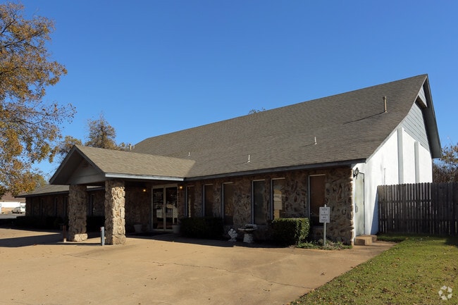
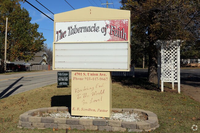
4701 S Union Ave
40925-92-26-01320
W125 FT LOS16&17
Religious
Tulsa
RS3
Oklahoma
B and X Area of moderate flood hazard, usually the area between the limits of the 100-year and 500-year floods.
16
0
0.55 AC
2025
West
004900
Tulsa
3,960 SF
Tulsa, OK
NEARBY LISTINGS FOR SALE OR LEASE
-
-
View all Tulsa listings for sale on LoopNet.com
DEMOGRAPHICS near 4701 S Union Ave
1 mile
3 mile
5 mile
2025 Total Population
6,058
47,692
140,191
2030 Population
6,292
49,427
145,089
Pop Growth 2025-2030
+ 3.86%
+ 3.64%
+ 3.49%
Average Age
40
39
40
2025 Total Households
2,489
21,688
63,502
HH Growth 2025-2030
+ 3.98%
+ 3.77%
+ 3.63%
Median Household Inc
$49,865
$54,917
$61,237
Avg Household Size
2.30
2.10
2.10
2025 Avg HH Vehicles
2.00
2.00
2.00
Median Home Value
$106,004
$197,583
$271,935
Median Year Built
1957
1969
1968
Nearby Places
Map Layers
Map Styles
 Street
 Aerial
Layers
 Traffic
 Biking
Places
Listings with unknown addresses are not visible on the map
- Restaurants
- Banks
- Shops
- Fitness
- Groceries
PUBLIC TRANSPORTATION
AIRPORT
Tulsa International
Drive
Walk
Distance
Tulsa International
22 min
13.9 mi
SALE & LEASE HISTORY
LISTING DATE
SALE/LEASE

Sep 23, 2016
For Sale
Nearby Properties
Address
Land Use
TOTAL SIZE
Lot Size
Zoning
Address
Land Use
TOTAL SIZE
Lot Size
Zoning
1,134,776 SF
35.85 AC
CN
Address
Land Use
TOTAL SIZE
Lot Size
Zoning
49,992 SF
33.23 AC
AG
Address
Land Use
TOTAL SIZE
Lot Size
Zoning
290,963 SF
10.77 AC
RM1
Address
Land Use
TOTAL SIZE
Lot Size
Zoning
266,675 SF
12.31 AC
RM1
Address
Land Use
TOTAL SIZE
Lot Size
Zoning
119,056 SF
28.06 AC
CM
Address
Land Use
TOTAL SIZE
Lot Size
Zoning
147,881 SF
35.20 AC
RS2
Address
Land Use
TOTAL SIZE
Lot Size
Zoning
137,215 SF
5.08 AC
RM3
Address
Land Use
TOTAL SIZE
Lot Size
Zoning
88,702 SF
8.27 AC
IM
Address
Land Use
TOTAL SIZE
Lot Size
Zoning
21,693 SF
4.24 AC
Address
Land Use
TOTAL SIZE
Lot Size
Zoning
106,743 SF
4.34 AC
MX1U55
Address
Land Use
TOTAL SIZE
Lot Size
Zoning
89,640 SF
5.47 AC
MX1U55
Address
Land Use
TOTAL SIZE
Lot Size
Zoning
100,857 SF
4.04 AC
MX1U55
Address
Land Use
TOTAL SIZE
Lot Size
Zoning
132,105 SF
9.32 AC
RS3
Address
Land Use
TOTAL SIZE
Lot Size
Zoning
78,442 SF
31.24 AC
IM
Address
Land Use
TOTAL SIZE
Lot Size
Zoning
53,220 SF
4.93 AC
CH
Address
Land Use
TOTAL SIZE
Lot Size
Zoning
330,521 SF
22.04 AC
PUD
Address
Land Use
TOTAL SIZE
Lot Size
Zoning
84,791 SF
8.04 AC
RS3
Address
Land Use
TOTAL SIZE
Lot Size
Zoning
1,123,266 SF
87.29 AC
IM
Address
Land Use
TOTAL SIZE
Lot Size
Zoning
110,382 SF
9.81 AC
RS3
Address
Land Use
TOTAL SIZE
Lot Size
Zoning
35,845 SF
14.38 AC
CS
Address
Land Use
TOTAL SIZE
Lot Size
Zoning
394,728 SF
5.44 AC
CH
Address
Land Use
TOTAL SIZE
Lot Size
Zoning
102,070 SF
6.92 AC
IM
Address
Land Use
TOTAL SIZE
Lot Size
Zoning
198 SF
19.81 AC
RS3
Address
Land Use
TOTAL SIZE
Lot Size
Zoning
270,584 SF
28.85 AC
CO
Address
Land Use
TOTAL SIZE
Lot Size
Zoning
432 SF
72.60 AC
AG
Address
Land Use
TOTAL SIZE
Lot Size
Zoning
6,162 SF
4.25 AC
CH
Address
Land Use
TOTAL SIZE
Lot Size
Zoning
72,690 SF
8.04 AC
RS3
Address
Land Use
TOTAL SIZE
Lot Size
Zoning
27,225 SF
2.19 AC
MX1U55
Address
Land Use
TOTAL SIZE
Lot Size
Zoning
143,520 SF
25.14 AC
IM
Address
Land Use
TOTAL SIZE
Lot Size
Zoning
82,843 SF
4.10 AC
RS3
The World's #1 Commercial Real Estate Marketplace
Connect with us
© 2026 CoStar Group
The information above has been obtained from sources believed reliable. While we do not doubt its accuracy we have not verified it and make no guarantee, warranty or representation about it. It is your responsibility to independently confirm its accuracy and completeness. Any projections, opinions, assumptions, or estimates used are for example only and do not represent the current or future performance of the property. The value of this transaction to you depends on tax and other factors which should be evaluated by your tax, financial, and legal advisors. You and your advisors should conduct a careful, independent investigation of the property to determine to your satisfaction the suitability of the property for your needs.