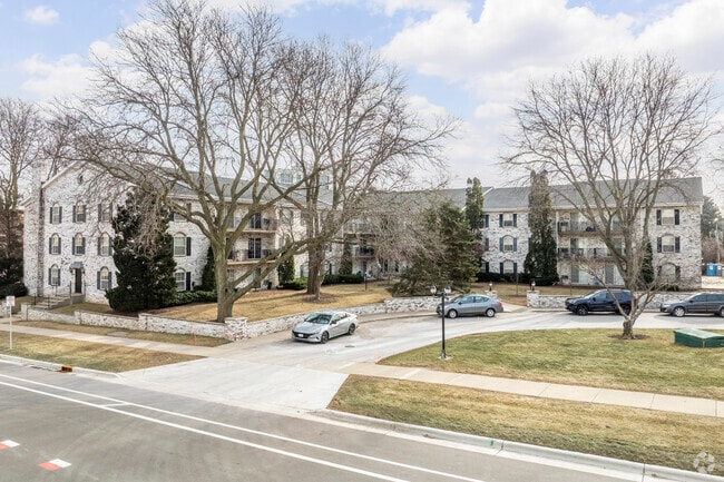
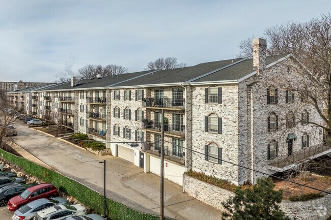
Property Record
4701 Sheboygan Ave, Madison, WI 53705

Property Detail
4701 Sheboygan Ave
0709-202-0803-4
CERTIFIED SURVEY MAP NO 26 AS RECORDED IN DANE COUNTY REGISTER OF DEEDS IN VOL 1 PAGE 26 OF CERTIFIED SURVEYS, LOT 2.
Commercialnec
DANE
TR-U2
Wisconsin
B and X Area of moderate flood hazard, usually the area between the limits of the 100-year and 500-year floods.
2
2025
6.17 AC
2025
Hill Farms-University
000301
Milwaukee/Madison
350,550 SF
Madison, WI
NEARBY LISTINGS FOR SALE OR LEASE
DEMOGRAPHICS near 4701 Sheboygan Ave
1 mile
3 mile
5 mile
2025 Total Population
12,521
132,118
256,687
2030 Population
13,066
143,194
272,456
Pop Growth 2025-2030
+ 4.35%
+ 8.38%
+ 6.14%
Average Age
40
37
36
2025 Total Households
6,464
55,956
114,038
HH Growth 2025-2030
+ 4.69%
+ 9.04%
+ 6.50%
Median Household Inc
$69,598
$71,100
$71,321
Avg Household Size
1.90
2.10
2.10
2025 Avg HH Vehicles
1.00
1.00
1.00
Median Home Value
$451,504
$446,459
$439,052
Median Year Built
1966
1981
1987
Nearby Places
Map Layers
Map Styles
 Street
 Aerial
Layers
 Traffic
 Biking
Places
Listings with unknown addresses are not visible on the map
- Restaurants
- Banks
- Shops
- Fitness
- Groceries
PUBLIC TRANSPORTATION
AIRPORT
Dane County Regional/Truax Field
Drive
Walk
Distance
Dane County Regional/Truax Field
20 min
9.2 mi
Freight Ports
Port Milwaukee
Drive
Walk
Distance
Port Milwaukee
107 min
83.7 mi
Nearby Properties
Address
Land Use
TOTAL SIZE
Lot Size
Zoning
Address
Land Use
TOTAL SIZE
Lot Size
Zoning
408,311 SF
9.26 AC
SE
Address
Land Use
TOTAL SIZE
Lot Size
Zoning
501,997 SF
26.90 AC
SE
Address
Land Use
TOTAL SIZE
Lot Size
Zoning
393,708 SF
2.89 AC
PD
Address
Land Use
TOTAL SIZE
Lot Size
Zoning
530,774 SF
37.40 AC
RMX
Address
Land Use
TOTAL SIZE
Lot Size
Zoning
210,515 SF
0.80 AC
UMX
Address
Land Use
TOTAL SIZE
Lot Size
Zoning
526,685 SF
23.94 AC
SR-V2
Address
Land Use
TOTAL SIZE
Lot Size
Zoning
156,908 SF
23.87 AC
SE
Address
Land Use
TOTAL SIZE
Lot Size
Zoning
262,260 SF
6.28 AC
TR-U2
Address
Land Use
TOTAL SIZE
Lot Size
Zoning
317,128 SF
10.14 AC
PD
Address
Land Use
TOTAL SIZE
Lot Size
Zoning
557,272 SF
28.49 AC
PD
Address
Land Use
TOTAL SIZE
Lot Size
Zoning
217,664 SF
1.43 AC
TE
Address
Land Use
TOTAL SIZE
Lot Size
Zoning
242,105 SF
2.23 AC
TSS
Address
Land Use
TOTAL SIZE
Lot Size
Zoning
51,205 SF
9.32 AC
SE
Address
Land Use
TOTAL SIZE
Lot Size
Zoning
174,113 SF
2.71 AC
PD
Address
Land Use
TOTAL SIZE
Lot Size
Zoning
181,893 SF
0.64 AC
PD
Address
Land Use
TOTAL SIZE
Lot Size
Zoning
2.91 AC
CC-T
Address
Land Use
TOTAL SIZE
Lot Size
Zoning
217,919 SF
11.97 AC
PD
Address
Land Use
TOTAL SIZE
Lot Size
Zoning
360,223 SF
PD
Address
Land Use
TOTAL SIZE
Lot Size
Zoning
170,606 SF
1.08 AC
PD
Address
Land Use
TOTAL SIZE
Lot Size
Zoning
180,250 SF
0.58 AC
PD
Address
Land Use
TOTAL SIZE
Lot Size
Zoning
181,766 SF
1.84 AC
PD
Address
Land Use
TOTAL SIZE
Lot Size
Zoning
151,983 SF
8.50 AC
SR-V2
Address
Land Use
TOTAL SIZE
Lot Size
Zoning
164,268 SF
14.37 AC
PD
Address
Land Use
TOTAL SIZE
Lot Size
Zoning
222,406 SF
0.01 AC
PD
Address
Land Use
TOTAL SIZE
Lot Size
Zoning
95,530 SF
0.45 AC
PD
Address
Land Use
TOTAL SIZE
Lot Size
Zoning
121,671 SF
3.70 AC
PD
Address
Land Use
TOTAL SIZE
Lot Size
Zoning
48,807 SF
2.89 AC
PD
Address
Land Use
TOTAL SIZE
Lot Size
Zoning
101,700 SF
6.76 AC
CC
Address
Land Use
TOTAL SIZE
Lot Size
Zoning
139,988 SF
228.01 AC
PD
The World's #1 Commercial Real Estate Marketplace
Connect with us
© 2026 CoStar Group
The information above has been obtained from sources believed reliable. While we do not doubt its accuracy we have not verified it and make no guarantee, warranty or representation about it. It is your responsibility to independently confirm its accuracy and completeness. Any projections, opinions, assumptions, or estimates used are for example only and do not represent the current or future performance of the property. The value of this transaction to you depends on tax and other factors which should be evaluated by your tax, financial, and legal advisors. You and your advisors should conduct a careful, independent investigation of the property to determine to your satisfaction the suitability of the property for your needs.