Property Record
4702 S College Rd S, Wilmington, NC 28412
NEARBY LISTINGS FOR SALE OR LEASE
-
-
View all Wilmington listings for sale on LoopNet.com
Property Detail
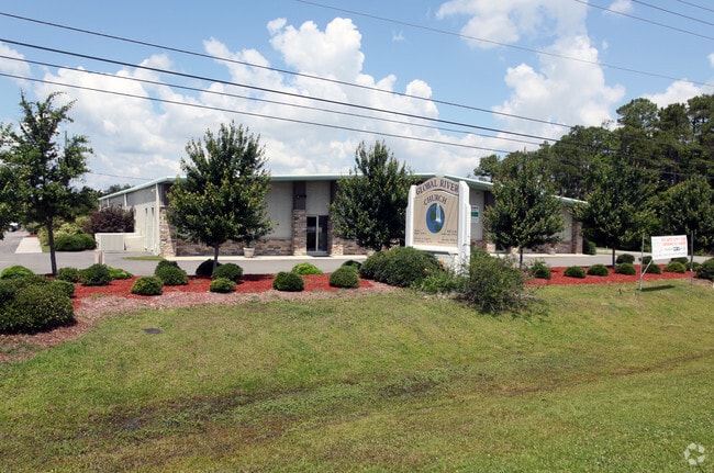
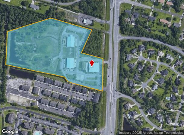
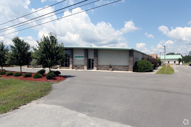
4702 S College Rd S
Wilmington, NC
Coastal Comm Vineyard Sani Esmt
R07100-003-044-000
COASTAL COMMUNITY VINEYARD
Publicschool
New Hanover
X
North Carolina
3720313400K
44
0
12.10 AC
2025
Monkey Junction
012008
Wilmington
2,152 SF
DEMOGRAPHICS near 4702 S College Rd S
1 Mile
3 Mile
5 Mile
2024 Total Population
9,874
55,047
95,598
2029 Population
10,620
59,983
103,883
Pop Growth 2024-2029
+ 7.56%
+ 8.97%
+ 8.67%
Average Age
40
42
41
2024 Total Households
4,350
23,753
41,662
HH Growth 2024-2029
+ 7.95%
+ 9.43%
+ 9.10%
Median Household Inc
$70,385
$75,683
$65,469
Avg Household Size
2.20
2.30
2.20
2024 Avg HH Vehicles
2.00
2.00
2.00
Median Home Value
$281,308
$313,270
$308,172
Median Year Built
1997
1996
1992
Nearby Places
Map Layers
Map Styles
 Street
 Aerial
- Restaurants
- Banks
- Shops
- Fitness
- Groceries
PUBLIC TRANSPORTATION
AIRPORT
Wilmington International
DRIVE
WALK
Distance
Wilmington International
27 min
13.5 mi
Freight Ports
Port of Wilmington
DRIVE
WALK
Distance
Port of Wilmington
13 min
6.6 mi
Nearby Properties
Address
Land Use
TOTAL SIZE
Lot Size
Zoning
Address
Land Use
TOTAL SIZE
Lot Size
Zoning
49,980 SF
48.54 AC
EDZD
Address
Land Use
TOTAL SIZE
Lot Size
Zoning
1,152 SF
21.73 AC
MX
Address
Land Use
TOTAL SIZE
Lot Size
Zoning
228,521 SF
25.17 AC
RB,REGIONA
Address
Land Use
TOTAL SIZE
Lot Size
Zoning
94.15 AC
RB,REGIONA
Address
Land Use
TOTAL SIZE
Lot Size
Zoning
1,646 SF
48.98 AC
R-15,RESID
Address
Land Use
TOTAL SIZE
Lot Size
Zoning
39,866 SF
15.89 AC
R-15,RESID
Address
Land Use
TOTAL SIZE
Lot Size
Zoning
120,825 SF
22.34 AC
B-2,BUSINE
Address
Land Use
TOTAL SIZE
Lot Size
Zoning
3,190 SF
59.66 AC
R-15,RESID
Address
Land Use
TOTAL SIZE
Lot Size
Zoning
64,100 SF
6.66 AC
O&I,OFFICE
Address
Land Use
TOTAL SIZE
Lot Size
Zoning
200,344 SF
15.47 AC
IND
Address
Land Use
TOTAL SIZE
Lot Size
Zoning
180,000 SF
14.67 AC
IND
Address
Land Use
TOTAL SIZE
Lot Size
Zoning
4,902 SF
39.46 AC
IND
Address
Land Use
TOTAL SIZE
Lot Size
Zoning
16,922 SF
4.96 AC
RB,REGIONA
Address
Land Use
TOTAL SIZE
Lot Size
Zoning
55,917 SF
9.75 AC
RB,REGIONA
Address
Land Use
TOTAL SIZE
Lot Size
Zoning
100,430 SF
25.96 AC
R-15,RESID
Address
Land Use
TOTAL SIZE
Lot Size
Zoning
71,282 SF
8.70 AC
CB,COMMUNI
Address
Land Use
TOTAL SIZE
Lot Size
Zoning
84,162 SF
5.05 AC
O&I,OFFICE
Address
Land Use
TOTAL SIZE
Lot Size
Zoning
31,706 SF
8.52 AC
O&I,OFFICE
Address
Land Use
TOTAL SIZE
Lot Size
Zoning
1,872 SF
1.23 AC
I-1,INDUST
Address
Land Use
TOTAL SIZE
Lot Size
Zoning
206,988 SF
24.80 AC
B-2,BUSINE
Address
Land Use
TOTAL SIZE
Lot Size
Zoning
55,910 SF
3.88 AC
CS,COMMERC
Address
Land Use
TOTAL SIZE
Lot Size
Zoning
70,845 SF
3.86 AC
R-15,RESID
Address
Land Use
TOTAL SIZE
Lot Size
Zoning
25,550 SF
7.08 AC
B-2,BUSINE
Address
Land Use
TOTAL SIZE
Lot Size
Zoning
81,330 SF
15.02 AC
O&I,OFFICE
Address
Land Use
TOTAL SIZE
Lot Size
Zoning
62.44 AC
O&I,OFFICE
Address
Land Use
TOTAL SIZE
Lot Size
Zoning
7,320 SF
19.68 AC
B-2,BUSINE
Address
Land Use
TOTAL SIZE
Lot Size
Zoning
16,000 SF
10.04 AC
B-2,BUSINE
Address
Land Use
TOTAL SIZE
Lot Size
Zoning
14,912 SF
9.61 AC
I-2,INDUST
Address
Land Use
TOTAL SIZE
Lot Size
Zoning
67,284 SF
9.39 AC
O&I,OFFICE
Address
Land Use
TOTAL SIZE
Lot Size
Zoning
75,200 SF
10.65 AC
I-2,INDUST
The World's #1 Commercial Real Estate Marketplace
Connect with us
© 2026 CoStar Group
The information above has been obtained from sources believed reliable. While we do not doubt its accuracy we have not verified it and make no guarantee, warranty or representation about it. It is your responsibility to independently confirm its accuracy and completeness. Any projections, opinions, assumptions, or estimates used are for example only and do not represent the current or future performance of the property. The value of this transaction to you depends on tax and other factors which should be evaluated by your tax, financial, and legal advisors. You and your advisors should conduct a careful, independent investigation of the property to determine to your satisfaction the suitability of the property for your needs.