Property Record
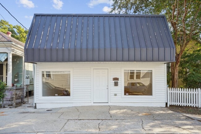
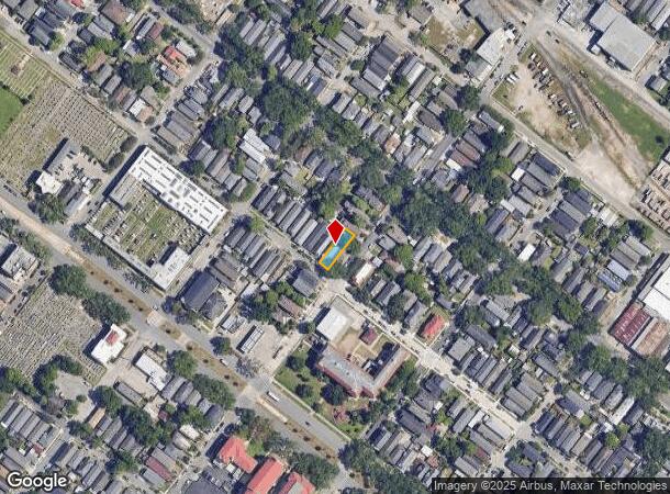
4707 Iberville St, New Orleans, LA 70119
This Property Is For Sale
NEARBY LISTINGS FOR SALE OR LEASE
Property Detail
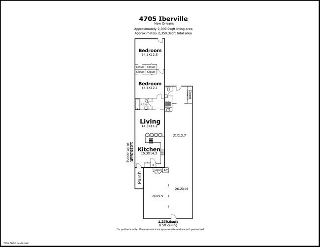
4707 Iberville St
2-06-2-103-02
SQ 611 LOT 2 IBERVILLE 31X120 4705-07 IBERVILLE ST
Miscresidentialimprovement
Orleans
X
Louisiana
22051C0225F
2
2025
0.09 AC
2025
Mid-City/Central City
005400
New Orleans/Metairie/Kenner
1,810 SF
New Orleans-Metairie, LA
DEMOGRAPHICS near 4707 Iberville St
1 Mile
3 Mile
5 Mile
2024 Total Population
14,638
164,120
341,810
2029 Population
13,907
159,661
333,261
Pop Growth 2024-2029
(4.99%)
(2.72%)
(2.50%)
Average Age
41
41
42
2024 Total Households
7,318
74,353
156,443
HH Growth 2024-2029
(5.45%)
(2.77%)
(2.59%)
Median Household Inc
$67,982
$62,401
$65,377
Avg Household Size
1.90
2.00
2.10
2024 Avg HH Vehicles
1.00
1.00
1.00
Median Home Value
$420,077
$412,616
$381,129
Median Year Built
1947
1952
1955
Nearby Places
Map Layers
Map Styles
 Street
 Aerial
- Restaurants
- Banks
- Shops
- Fitness
- Groceries
PUBLIC TRANSPORTATION
TRANSIT/SUBWAY
Canal and St Patrick (Canal-Cemeteries Streetcar - New Orleans Regional Transit Authority Streetcars (New Orleans Streetcars))
DRIVE
WALK
Distance
Canal and St Patrick (Canal-Cemeteries Streetcar - New Orleans Regional Transit Authority Streetcars (New Orleans Streetcars))
0 min
2 min
0.1 mi
Canal and Anthony/Botinelli (Canal-Cemeteries Streetcar - New Orleans Regional Transit Authority Streetcars (New Orleans Streetcars))
DRIVE
WALK
Distance
Canal and Anthony/Botinelli (Canal-Cemeteries Streetcar - New Orleans Regional Transit Authority Streetcars (New Orleans Streetcars))
1 min
5 min
0.2 mi
Canal and Murat (Canal-Cemeteries Streetcar - New Orleans Regional Transit Authority Streetcars (New Orleans Streetcars))
DRIVE
WALK
Distance
Canal and Murat (Canal-Cemeteries Streetcar - New Orleans Regional Transit Authority Streetcars (New Orleans Streetcars))
1 min
5 min
0.3 mi
Canal and Hennessey (Canal-Cemeteries Streetcar - New Orleans Regional Transit Authority Streetcars (New Orleans Streetcars))
DRIVE
WALK
Distance
Canal and Hennessey (Canal-Cemeteries Streetcar - New Orleans Regional Transit Authority Streetcars (New Orleans Streetcars))
1 min
8 min
0.4 mi
Cemeteries-Canal and City Park (Canal-Cemeteries Streetcar - New Orleans Regional Transit Authority Streetcars (New Orleans Streetcars))
DRIVE
WALK
Distance
Cemeteries-Canal and City Park (Canal-Cemeteries Streetcar - New Orleans Regional Transit Authority Streetcars (New Orleans Streetcars))
1 min
8 min
0.4 mi
COMMUTER RAIL
DRIVE
WALK
Distance
9 min
4.0 mi
AIRPORT
Louis Armstrong New Orleans International
DRIVE
WALK
Distance
Louis Armstrong New Orleans International
18 min
11.8 mi
Freight Ports
Port of New Orleans
DRIVE
WALK
Distance
Port of New Orleans
15 min
6.1 mi
Nearby Properties
Address
Land Use
TOTAL SIZE
Lot Size
Zoning
Address
Land Use
TOTAL SIZE
Lot Size
Zoning
300 SF
2.19 AC
LS
Address
Land Use
TOTAL SIZE
Lot Size
Zoning
85,052 SF
2.19 AC
LS
Address
Land Use
TOTAL SIZE
Lot Size
Zoning
80.92 AC
EC
Address
Land Use
TOTAL SIZE
Lot Size
Zoning
22.63 AC
Address
Land Use
TOTAL SIZE
Lot Size
Zoning
66.23 AC
CBD-4
Address
Land Use
TOTAL SIZE
Lot Size
Zoning
1.87 AC
CBD-2
Address
Land Use
TOTAL SIZE
Lot Size
Zoning
0.88 AC
CBD-2
Address
Land Use
TOTAL SIZE
Lot Size
Zoning
725,677 SF
54.19 AC
EC
Address
Land Use
TOTAL SIZE
Lot Size
Zoning
1.91 AC
CBD-1
Address
Land Use
TOTAL SIZE
Lot Size
Zoning
1.24 AC
CBD-1
Address
Land Use
TOTAL SIZE
Lot Size
Zoning
190,708 SF
1.09 AC
CBD-2
Address
Land Use
TOTAL SIZE
Lot Size
Zoning
225,284 SF
16.83 AC
S-RD
Address
Land Use
TOTAL SIZE
Lot Size
Zoning
499,287 SF
1.44 AC
VCE
Address
Land Use
TOTAL SIZE
Lot Size
Zoning
162,382 SF
1.25 AC
CBD-2
Address
Land Use
TOTAL SIZE
Lot Size
Zoning
35.06 AC
Address
Land Use
TOTAL SIZE
Lot Size
Zoning
258,024 SF
0.63 AC
CBD-2
Address
Land Use
TOTAL SIZE
Lot Size
Zoning
4.31 AC
BC2
Address
Land Use
TOTAL SIZE
Lot Size
Zoning
3.36 AC
EC
Address
Land Use
TOTAL SIZE
Lot Size
Zoning
462,672 SF
1.11 AC
CBD-1
Address
Land Use
TOTAL SIZE
Lot Size
Zoning
1.84 AC
CBD-7
Address
Land Use
TOTAL SIZE
Lot Size
Zoning
224,374 SF
92.67 AC
HU-RD1
Address
Land Use
TOTAL SIZE
Lot Size
Zoning
7.56 AC
S-LRS1
Address
Land Use
TOTAL SIZE
Lot Size
Zoning
2.20 AC
EC
Address
Land Use
TOTAL SIZE
Lot Size
Zoning
1.26 AC
CBD-1
Address
Land Use
TOTAL SIZE
Lot Size
Zoning
63.72 AC
OS-N
Address
Land Use
TOTAL SIZE
Lot Size
Zoning
246,930 SF
9.40 AC
CBD-4
Address
Land Use
TOTAL SIZE
Lot Size
Zoning
288,736 SF
0.84 AC
VCC-2
Address
Land Use
TOTAL SIZE
Lot Size
Zoning
14.83 AC
EC
Address
Land Use
TOTAL SIZE
Lot Size
Zoning
66.97 AC
LI
The World's #1 Commercial Real Estate Marketplace
Connect with us
© 2026 CoStar Group
The information above has been obtained from sources believed reliable. While we do not doubt its accuracy we have not verified it and make no guarantee, warranty or representation about it. It is your responsibility to independently confirm its accuracy and completeness. Any projections, opinions, assumptions, or estimates used are for example only and do not represent the current or future performance of the property. The value of this transaction to you depends on tax and other factors which should be evaluated by your tax, financial, and legal advisors. You and your advisors should conduct a careful, independent investigation of the property to determine to your satisfaction the suitability of the property for your needs.