Property Record
4705 N River Rd, Oceanside, CA 92057
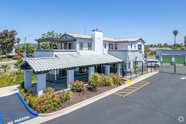

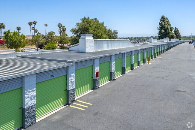
Property Detail
4705 N River Rd
157-060-42
PAR 3 TR PM14211
Shipyard
San Diego
IL
California
A99 Areas with a 1% annual chance of flooding that will be protected by a Federal flood control system where construction has reached specified legal requirements.
10 AC
2024
Oceanside
2025
San Diego
018521
San Diego-Chula Vista-Carlsbad, CA
97,066 SF
NEARBY LISTINGS FOR SALE OR LEASE
-
-
View all Oceanside listings for sale on LoopNet.com
DEMOGRAPHICS near 4705 N River Rd
1 mile
3 mile
5 mile
2025 Total Population
24,073
90,884
229,366
2030 Population
23,902
90,954
230,070
Pop Growth 2025-2030
(0.71%)
+ 0.08%
+ 0.31%
Average Age
38
41
38
2025 Total Households
7,127
30,789
73,821
HH Growth 2025-2030
(0.86%)
+ 0.06%
+ 0.22%
Median Household Inc
$99,271
$104,114
$94,317
Avg Household Size
3.20
2.80
2.90
2025 Avg HH Vehicles
2.00
2.00
2.00
Median Home Value
$659,251
$721,067
$727,908
Median Year Built
1985
1987
1984
Nearby Places
Map Layers
Map Styles
 Street
 Aerial
Layers
 Traffic
 Biking
Places
Listings with unknown addresses are not visible on the map
- Restaurants
- Banks
- Shops
- Fitness
- Groceries
PUBLIC TRANSPORTATION
COMMUTER RAIL
Oceanside Transit Center (Metrolink Inland Empire-Orange County Line - Metrolink Trains, Metrolink Orange County Line - Metrolink Trains, Orange County Line - Metrolink Trains)
Drive
Walk
Distance
Oceanside Transit Center (Metrolink Inland Empire-Orange County Line - Metrolink Trains, Metrolink Orange County Line - Metrolink Trains, Orange County Line - Metrolink Trains)
14 min
6.8 mi
Carlsbad Village (Coaster - San Diego North County Transit District (Coaster/Sprinter/Breeze))
Drive
Walk
Distance
Carlsbad Village (Coaster - San Diego North County Transit District (Coaster/Sprinter/Breeze))
17 min
8.7 mi
Freight Ports
Port of San Diego
Drive
Walk
Distance
Port of San Diego
60 min
45.3 mi
Nearby Properties
Address
Land Use
TOTAL SIZE
Lot Size
Zoning
Address
Land Use
TOTAL SIZE
Lot Size
Zoning
20.96 AC
SP-1-84 (I
Address
Land Use
TOTAL SIZE
Lot Size
Zoning
15.74 AC
SP-1-84 (I
Address
Land Use
TOTAL SIZE
Lot Size
Zoning
18.89 AC
PD-1 (Res)
Address
Land Use
TOTAL SIZE
Lot Size
Zoning
31.94 AC
RM-B
Address
Land Use
TOTAL SIZE
Lot Size
Zoning
38.61 AC
PD-1 (IL)
Address
Land Use
TOTAL SIZE
Lot Size
Zoning
9.22 AC
RH
Address
Land Use
TOTAL SIZE
Lot Size
Zoning
12 AC
SP-1-09
Address
Land Use
TOTAL SIZE
Lot Size
Zoning
8.01 AC
PD-19-H
Address
Land Use
TOTAL SIZE
Lot Size
Zoning
6.87 AC
CN-SP-EQ
Address
Land Use
TOTAL SIZE
Lot Size
Zoning
5.24 AC
SP-1-09
Address
Land Use
TOTAL SIZE
Lot Size
Zoning
14.08 AC
RH
Address
Land Use
TOTAL SIZE
Lot Size
Zoning
15.02 AC
SP-1-84 (I
Address
Land Use
TOTAL SIZE
Lot Size
Zoning
25.16 AC
SP-1-84 (I
Address
Land Use
TOTAL SIZE
Lot Size
Zoning
65,156 SF
2.52 AC
PD-1 (IL)
Address
Land Use
TOTAL SIZE
Lot Size
Zoning
11.60 AC
RM-C
Address
Land Use
TOTAL SIZE
Lot Size
Zoning
10,500 SF
43.77 AC
RM-A-SMH
Address
Land Use
TOTAL SIZE
Lot Size
Zoning
78,489 SF
2.67 AC
PD-1 (IL)
Address
Land Use
TOTAL SIZE
Lot Size
Zoning
83,995 SF
5.88 AC
PD-1 (IL)
Address
Land Use
TOTAL SIZE
Lot Size
Zoning
15.81 AC
SP-1-84 (I
Address
Land Use
TOTAL SIZE
Lot Size
Zoning
2.98 AC
SP-1-84 (I
Address
Land Use
TOTAL SIZE
Lot Size
Zoning
99,771 SF
4.22 AC
SP-1-84
Address
Land Use
TOTAL SIZE
Lot Size
Zoning
11.76 AC
SP-1-84 (I
Address
Land Use
TOTAL SIZE
Lot Size
Zoning
15.61 AC
PD-1 (C)
Address
Land Use
TOTAL SIZE
Lot Size
Zoning
57,489 SF
6.49 AC
PD-1 (IL)
Address
Land Use
TOTAL SIZE
Lot Size
Zoning
15.53 AC
SP-1-09 (R
Address
Land Use
TOTAL SIZE
Lot Size
Zoning
8.98 AC
RM-C-H
Address
Land Use
TOTAL SIZE
Lot Size
Zoning
20.17 AC
PD-1 (Res)
Address
Land Use
TOTAL SIZE
Lot Size
Zoning
10.05 AC
RM-B
Address
Land Use
TOTAL SIZE
Lot Size
Zoning
32.65 AC
SP-1-84 (I
Address
Land Use
TOTAL SIZE
Lot Size
Zoning
14.14 AC
SP-1-84 (I
The World's #1 Commercial Real Estate Marketplace
Connect with us
© 2026 CoStar Group
The information above has been obtained from sources believed reliable. While we do not doubt its accuracy we have not verified it and make no guarantee, warranty or representation about it. It is your responsibility to independently confirm its accuracy and completeness. Any projections, opinions, assumptions, or estimates used are for example only and do not represent the current or future performance of the property. The value of this transaction to you depends on tax and other factors which should be evaluated by your tax, financial, and legal advisors. You and your advisors should conduct a careful, independent investigation of the property to determine to your satisfaction the suitability of the property for your needs.