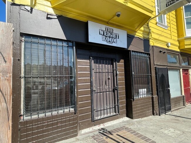
Property Record
4700 3Rd St, San Francisco, CA 94124

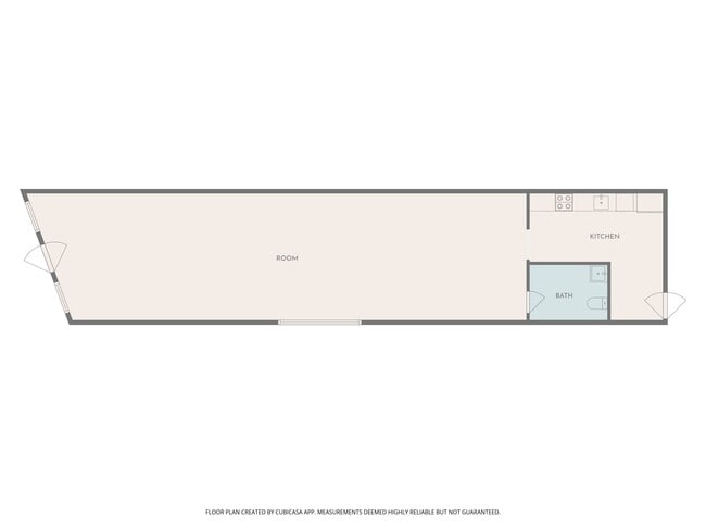
Current Lease Availabilities
NEARBY LISTINGS FOR SALE OR LEASE
Property Detail
4700 3Rd St
San Francisco-Redwood City-South San Francisco, CA
San Francisco
5311-039
California
Storemultistory
39
0
0.12 AC
2025
Bayview/Hunters Point
061200
San Francisco
5,320 SF
DEMOGRAPHICS near 4700 3Rd St
1 Mile
3 Mile
5 Mile
2024 Total Population
30,106
268,508
718,095
2029 Population
29,716
270,921
726,222
Pop Growth 2024-2029
(1.30%)
+ 0.90%
+ 1.13%
Average Age
41
42
43
2024 Total Households
8,618
98,655
300,373
HH Growth 2024-2029
(1.52%)
+ 1.10%
+ 1.33%
Median Household Inc
$79,046
$137,822
$127,201
Avg Household Size
3.10
2.50
2.20
2024 Avg HH Vehicles
1.00
1.00
1.00
Median Home Value
$1,020,035
$1,086,377
$1,085,202
Median Year Built
1959
1953
1951
Nearby Places
Map Layers
Map Styles
 Street
 Aerial
- Restaurants
- Banks
- Shops
- Fitness
- Groceries
PUBLIC TRANSPORTATION
TRANSIT/SUBWAY
Oakdale/Palou Station (T Third Street - San Francisco Municipal Railway (MUNI Metro), THIRD - San Francisco Municipal Railway (MUNI Metro))
DRIVE
WALK
Distance
Oakdale/Palou Station (T Third Street - San Francisco Municipal Railway (MUNI Metro), THIRD - San Francisco Municipal Railway (MUNI Metro))
0 min
1 min
0.1 mi
Kirkwood/La Salle Station (T Third Street - San Francisco Municipal Railway (MUNI Metro), THIRD - San Francisco Municipal Railway (MUNI Metro))
DRIVE
WALK
Distance
Kirkwood/La Salle Station (T Third Street - San Francisco Municipal Railway (MUNI Metro), THIRD - San Francisco Municipal Railway (MUNI Metro))
1 min
3 min
0.2 mi
Revere Ave & 3Rd St (T Third Street - San Francisco Municipal Railway (MUNI Metro), THIRD - San Francisco Municipal Railway (MUNI Metro))
DRIVE
WALK
Distance
Revere Ave & 3Rd St (T Third Street - San Francisco Municipal Railway (MUNI Metro), THIRD - San Francisco Municipal Railway (MUNI Metro))
1 min
5 min
0.3 mi
Hudson/Innes Station (T Third Street - San Francisco Municipal Railway (MUNI Metro), THIRD - San Francisco Municipal Railway (MUNI Metro))
DRIVE
WALK
Distance
Hudson/Innes Station (T Third Street - San Francisco Municipal Railway (MUNI Metro), THIRD - San Francisco Municipal Railway (MUNI Metro))
1 min
7 min
0.4 mi
Williams Station Outbound (T Third Street - San Francisco Municipal Railway (MUNI Metro))
DRIVE
WALK
Distance
Williams Station Outbound (T Third Street - San Francisco Municipal Railway (MUNI Metro))
2 min
9 min
0.5 mi
COMMUTER RAIL
22Nd Street Caltrain Station Southbound (Express - Caltrain (Caltrain), Limited - Caltrain (Caltrain), Local Weekday - Caltrain (Caltrain), Local Weekend - Caltrain (Caltrain))
DRIVE
WALK
Distance
22Nd Street Caltrain Station Southbound (Express - Caltrain (Caltrain), Limited - Caltrain (Caltrain), Local Weekday - Caltrain (Caltrain), Local Weekend - Caltrain (Caltrain))
7 min
2.8 mi
22Nd Street (Caltrain - Caltrain (Caltrain))
DRIVE
WALK
Distance
22Nd Street (Caltrain - Caltrain (Caltrain))
7 min
2.8 mi
AIRPORT
San Francisco International
DRIVE
WALK
Distance
San Francisco International
17 min
10.6 mi
Metro Oakland International
DRIVE
WALK
Distance
Metro Oakland International
34 min
22.5 mi
Freight Ports
Port of San Francisco
DRIVE
WALK
Distance
Port of San Francisco
12 min
5.5 mi
Nearby Properties
Address
Land Use
TOTAL SIZE
Lot Size
Zoning
Address
Land Use
TOTAL SIZE
Lot Size
Zoning
750,370 SF
3.25 AC
MBR3
Address
Land Use
TOTAL SIZE
Lot Size
Zoning
248,303 SF
4.35 AC
Address
Land Use
TOTAL SIZE
Lot Size
Zoning
717,234 SF
3.47 AC
UMU
Address
Land Use
TOTAL SIZE
Lot Size
Zoning
10.92 AC
Address
Land Use
TOTAL SIZE
Lot Size
Zoning
885,581 SF
5.20 AC
M2
Address
Land Use
TOTAL SIZE
Lot Size
Zoning
2.74 AC
Address
Land Use
TOTAL SIZE
Lot Size
Zoning
313,306 SF
1.23 AC
WMUG
Address
Land Use
TOTAL SIZE
Lot Size
Zoning
314,826 SF
1.85 AC
MB-RA
Address
Land Use
TOTAL SIZE
Lot Size
Zoning
10.92 AC
Address
Land Use
TOTAL SIZE
Lot Size
Zoning
393,918 SF
3.36 AC
WMUG
Address
Land Use
TOTAL SIZE
Lot Size
Zoning
241,659 SF
3.76 AC
Address
Land Use
TOTAL SIZE
Lot Size
Zoning
230,853 SF
3.76 AC
Address
Land Use
TOTAL SIZE
Lot Size
Zoning
302,084 SF
0.88 AC
MBO
Address
Land Use
TOTAL SIZE
Lot Size
Zoning
674,317 SF
3.36 AC
UMU
Address
Land Use
TOTAL SIZE
Lot Size
Zoning
319,119 SF
0.76 AC
Address
Land Use
TOTAL SIZE
Lot Size
Zoning
222,000 SF
1 AC
MB-RA
Address
Land Use
TOTAL SIZE
Lot Size
Zoning
10.92 AC
Address
Land Use
TOTAL SIZE
Lot Size
Zoning
250,884 SF
1.66 AC
MB-RA
Address
Land Use
TOTAL SIZE
Lot Size
Zoning
375,030 SF
0.96 AC
Address
Land Use
TOTAL SIZE
Lot Size
Zoning
248,974 SF
0.88 AC
MBO
Address
Land Use
TOTAL SIZE
Lot Size
Zoning
345,000 SF
1.74 AC
WMUG
Address
Land Use
TOTAL SIZE
Lot Size
Zoning
2.22 AC
M1
Address
Land Use
TOTAL SIZE
Lot Size
Zoning
2.06 AC
Address
Land Use
TOTAL SIZE
Lot Size
Zoning
333,244 SF
2.67 AC
UMU
Address
Land Use
TOTAL SIZE
Lot Size
Zoning
300,000 SF
0.93 AC
Address
Land Use
TOTAL SIZE
Lot Size
Zoning
347,857 SF
2.76 AC
Address
Land Use
TOTAL SIZE
Lot Size
Zoning
346,710 SF
7.45 AC
RH2
Address
Land Use
TOTAL SIZE
Lot Size
Zoning
167,053 SF
0.99 AC
MB-RA
Address
Land Use
TOTAL SIZE
Lot Size
Zoning
3.49 AC
Address
Land Use
TOTAL SIZE
Lot Size
Zoning
100,732 SF
4.55 AC
M2
The World's #1 Commercial Real Estate Marketplace
Connect with us
© 2025 CoStar Group
The information above has been obtained from sources believed reliable. While we do not doubt its accuracy we have not verified it and make no guarantee, warranty or representation about it. It is your responsibility to independently confirm its accuracy and completeness. Any projections, opinions, assumptions, or estimates used are for example only and do not represent the current or future performance of the property. The value of this transaction to you depends on tax and other factors which should be evaluated by your tax, financial, and legal advisors. You and your advisors should conduct a careful, independent investigation of the property to determine to your satisfaction the suitability of the property for your needs.