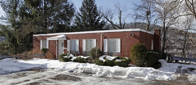
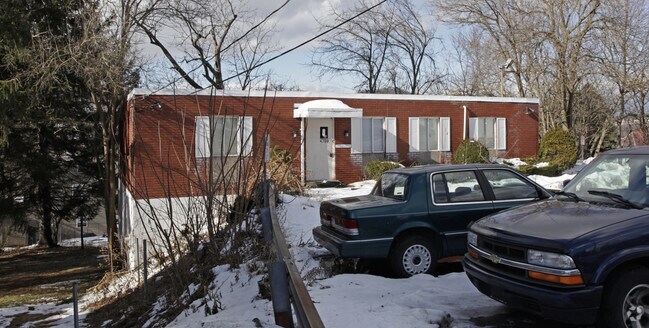
Property Record
4706 Walnut St, Mckeesport, PA 15132

Property Detail
4706 Walnut St
Pittsburgh, PA
BISSELL PLAN 77 & PTS 74-75 LOT = 55.07X133.43X22.91X36.50X102.50X40.00X75.00X64.72
0555-S-00104-0000-00
Allegheny
Officebuilding
Pennsylvania
B and X Area of moderate flood hazard, usually the area between the limits of the 100-year and 500-year floods.
104
2024
0.34 AC
2025
Parkway East Corridor
501000
Pittsburgh
NEARBY LISTINGS FOR SALE OR LEASE
DEMOGRAPHICS near 4706 Walnut St
1 mile
3 mile
5 mile
2025 Total Population
3,750
43,906
102,605
2030 Population
3,690
43,868
102,314
Pop Growth 2025-2030
(1.60%)
(0.09%)
(0.28%)
Average Age
45
44
44
2025 Total Households
1,767
19,390
45,602
HH Growth 2025-2030
(1.58%)
(0.18%)
(0.33%)
Median Household Inc
$56,481
$50,477
$57,720
Avg Household Size
2.10
2.20
2.20
2025 Avg HH Vehicles
2.00
1.00
2.00
Median Home Value
$125,706
$119,613
$139,851
Median Year Built
1953
1953
1955
Nearby Places
Map Layers
Map Styles
 Street
 Aerial
Layers
 Traffic
 Biking
Places
Listings with unknown addresses are not visible on the map
- Restaurants
- Banks
- Shops
- Fitness
- Groceries
PUBLIC TRANSPORTATION
AIRPORT
Arnold Palmer Regional
Drive
Walk
Distance
Arnold Palmer Regional
51 min
27.3 mi
Pittsburgh International
Drive
Walk
Distance
Pittsburgh International
57 min
34.8 mi
Nearby Properties
Address
Land Use
TOTAL SIZE
Lot Size
Zoning
Address
Land Use
TOTAL SIZE
Lot Size
Zoning
5.98 AC
Address
Land Use
TOTAL SIZE
Lot Size
Zoning
49.22 AC
Address
Land Use
TOTAL SIZE
Lot Size
Zoning
10.68 AC
Address
Land Use
TOTAL SIZE
Lot Size
Zoning
11.31 AC
Address
Land Use
TOTAL SIZE
Lot Size
Zoning
29.17 AC
Address
Land Use
TOTAL SIZE
Lot Size
Zoning
43.15 AC
Address
Land Use
TOTAL SIZE
Lot Size
Zoning
969 SF
80.46 AC
Address
Land Use
TOTAL SIZE
Lot Size
Zoning
10.13 AC
Address
Land Use
TOTAL SIZE
Lot Size
Zoning
242.22 AC
Address
Land Use
TOTAL SIZE
Lot Size
Zoning
10.01 AC
Address
Land Use
TOTAL SIZE
Lot Size
Zoning
12.56 AC
Address
Land Use
TOTAL SIZE
Lot Size
Zoning
2.10 AC
Address
Land Use
TOTAL SIZE
Lot Size
Zoning
24.85 AC
Address
Land Use
TOTAL SIZE
Lot Size
Zoning
10.27 AC
Address
Land Use
TOTAL SIZE
Lot Size
Zoning
Address
Land Use
TOTAL SIZE
Lot Size
Zoning
4.59 AC
Address
Land Use
TOTAL SIZE
Lot Size
Zoning
15.07 AC
Address
Land Use
TOTAL SIZE
Lot Size
Zoning
16.87 AC
Address
Land Use
TOTAL SIZE
Lot Size
Zoning
24.86 AC
Address
Land Use
TOTAL SIZE
Lot Size
Zoning
13.93 AC
Address
Land Use
TOTAL SIZE
Lot Size
Zoning
1.96 AC
Address
Land Use
TOTAL SIZE
Lot Size
Zoning
12.60 AC
Address
Land Use
TOTAL SIZE
Lot Size
Zoning
18.54 AC
Address
Land Use
TOTAL SIZE
Lot Size
Zoning
18.97 AC
Address
Land Use
TOTAL SIZE
Lot Size
Zoning
Address
Land Use
TOTAL SIZE
Lot Size
Zoning
9.71 AC
Address
Land Use
TOTAL SIZE
Lot Size
Zoning
5.50 AC
Address
Land Use
TOTAL SIZE
Lot Size
Zoning
Address
Land Use
TOTAL SIZE
Lot Size
Zoning
5.63 AC
Address
Land Use
TOTAL SIZE
Lot Size
Zoning
9.83 AC
The World's #1 Commercial Real Estate Marketplace
Connect with us
© 2026 CoStar Group
The information above has been obtained from sources believed reliable. While we do not doubt its accuracy we have not verified it and make no guarantee, warranty or representation about it. It is your responsibility to independently confirm its accuracy and completeness. Any projections, opinions, assumptions, or estimates used are for example only and do not represent the current or future performance of the property. The value of this transaction to you depends on tax and other factors which should be evaluated by your tax, financial, and legal advisors. You and your advisors should conduct a careful, independent investigation of the property to determine to your satisfaction the suitability of the property for your needs.