Property Record
4707 Misty Ridge Cir, Birmingham, AL 35235

This Property Is For Sale
NEARBY LISTINGS FOR SALE OR LEASE
Property Detail
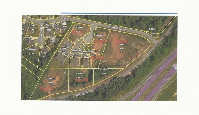
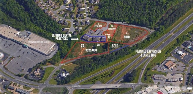
4707 Misty Ridge Cir
Birmingham-Hoover, AL
Misty Ridge Commercial Re
12-00-14-2-000-024.005
LOT 5-A MISTY RIDGE COMMERCIAL RESURVEY NO 1 PB 232 PG 85
Vacantlandnec
Jefferson
X
Alabama
01073C0263H
5-a
2023
0.75 AC
2024
Trussville
0111111078
Birmingham
DEMOGRAPHICS near 4707 Misty Ridge Cir
1 Mile
3 Mile
5 Mile
2024 Total Population
2,458
30,670
80,532
2029 Population
2,376
29,693
78,567
Pop Growth 2024-2029
(3.34%)
(3.19%)
(2.44%)
Average Age
40
39
38
2024 Total Households
920
11,491
29,883
HH Growth 2024-2029
(3.48%)
(3.27%)
(2.51%)
Median Household Inc
$79,924
$70,048
$61,087
Avg Household Size
2.60
2.60
2.60
2024 Avg HH Vehicles
2.00
2.00
2.00
Median Home Value
$302,036
$195,614
$178,917
Median Year Built
1993
1988
1981
Nearby Places
- Restaurants
- Banks
- Shops
- Fitness
- Groceries
PUBLIC TRANSPORTATION
AIRPORT
Birmingham-Shuttlesworth International
DRIVE
WALK
Distance
Birmingham-Shuttlesworth International
17 min
12.3 mi
Freight Ports
Port of Mobile
DRIVE
WALK
Distance
Port of Mobile
293 min
267.6 mi
Nearby Properties
Address
Land Use
TOTAL SIZE
Lot Size
Zoning
Address
Land Use
TOTAL SIZE
Lot Size
Zoning
346,184 SF
21.75 AC
I2
Address
Land Use
TOTAL SIZE
Lot Size
Zoning
204,463 SF
32.90 AC
PUD
Address
Land Use
TOTAL SIZE
Lot Size
Zoning
144,921 SF
9 AC
R4
Address
Land Use
TOTAL SIZE
Lot Size
Zoning
87,863 SF
13.20 AC
PUD
Address
Land Use
TOTAL SIZE
Lot Size
Zoning
204,269 SF
17.94 AC
PUD
Address
Land Use
TOTAL SIZE
Lot Size
Zoning
94,262 SF
17.30 AC
C-2
Address
Land Use
TOTAL SIZE
Lot Size
Zoning
134,442 SF
26 AC
PUD
Address
Land Use
TOTAL SIZE
Lot Size
Zoning
89,935 SF
29.32 AC
A1
Address
Land Use
TOTAL SIZE
Lot Size
Zoning
176,232 SF
5.20 AC
C2
Address
Land Use
TOTAL SIZE
Lot Size
Zoning
34,169 SF
2.56 AC
QC2
Address
Land Use
TOTAL SIZE
Lot Size
Zoning
53,864 SF
6.58 AC
C2
Address
Land Use
TOTAL SIZE
Lot Size
Zoning
49,858 SF
7.30 AC
C4
Address
Land Use
TOTAL SIZE
Lot Size
Zoning
74,218 SF
4.50 AC
C2
Address
Land Use
TOTAL SIZE
Lot Size
Zoning
62,944 SF
8.44 AC
C1
Address
Land Use
TOTAL SIZE
Lot Size
Zoning
97,652 SF
6.20 AC
C2
Address
Land Use
TOTAL SIZE
Lot Size
Zoning
89,761 SF
11 AC
PUD
Address
Land Use
TOTAL SIZE
Lot Size
Zoning
116,732 SF
4.06 AC
R-4
Address
Land Use
TOTAL SIZE
Lot Size
Zoning
101,606 SF
4.46 AC
C-2
Address
Land Use
TOTAL SIZE
Lot Size
Zoning
55,760 SF
24.85 AC
A1
Address
Land Use
TOTAL SIZE
Lot Size
Zoning
87,142 SF
10.80 AC
C-2
Address
Land Use
TOTAL SIZE
Lot Size
Zoning
94,370 SF
6.07 AC
C2
Address
Land Use
TOTAL SIZE
Lot Size
Zoning
29,422 SF
5.31 AC
C2
Address
Land Use
TOTAL SIZE
Lot Size
Zoning
55,000 SF
7.10 AC
C2&I
Address
Land Use
TOTAL SIZE
Lot Size
Zoning
43,451 SF
5.22 AC
INST
Address
Land Use
TOTAL SIZE
Lot Size
Zoning
67,270 SF
9.70 AC
C2
Address
Land Use
TOTAL SIZE
Lot Size
Zoning
11,872 SF
3.38 AC
QC2
Address
Land Use
TOTAL SIZE
Lot Size
Zoning
48,483 SF
5.05 AC
C1
Address
Land Use
TOTAL SIZE
Lot Size
Zoning
43,298 SF
5.59 AC
INST
Address
Land Use
TOTAL SIZE
Lot Size
Zoning
4.21 AC
C2
The World's #1 Commercial Real Estate Marketplace
Connect with us
© 2025 CoStar Group
The information above has been obtained from sources believed reliable. While we do not doubt its accuracy we have not verified it and make no guarantee, warranty or representation about it. It is your responsibility to independently confirm its accuracy and completeness. Any projections, opinions, assumptions, or estimates used are for example only and do not represent the current or future performance of the property. The value of this transaction to you depends on tax and other factors which should be evaluated by your tax, financial, and legal advisors. You and your advisors should conduct a careful, independent investigation of the property to determine to your satisfaction the suitability of the property for your needs.