Property Record
47080 98Th St, Sioux Falls, SD 57108


Save to a Folder
{{folder.Name}}
{{folder.ListingIds.length}} Properties
{{folder.ListingIds.length}} Property
Create a New Folder
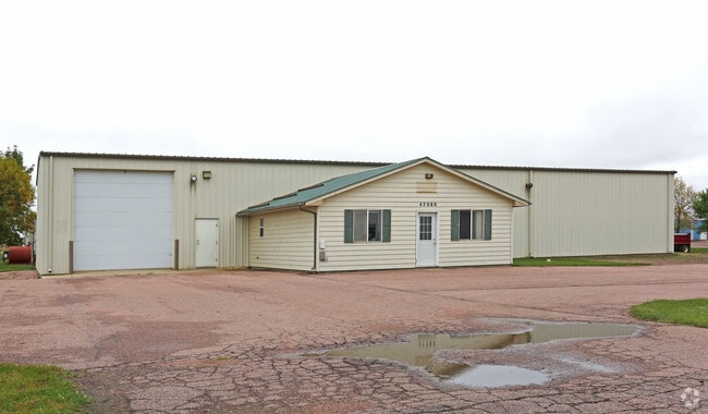
Property Detail
47080 98Th St
Sioux Falls, SD-MN
MUELLER'S TRACT 6E IN LOT 3A SE14 (EX LOT H-1) 19-100-50
100.50.19.A36E
Lincoln
Commercialnec
South Dakota
I-1 LIGHT
3a,h-1
B and X Area of moderate flood hazard, usually the area between the limits of the 100-year and 500-year floods.
1.02 AC
2025
Sioux Falls
2025
Other Market Areas
010110
NEARBY LISTINGS FOR SALE OR LEASE
DEMOGRAPHICS near 47080 98Th St
1 mile
3 mile
5 mile
2025 Total Population
1,788
37,668
95,492
2030 Population
2,022
41,803
103,997
Pop Growth 2025-2030
+ 13.09%
+ 10.98%
+ 8.91%
Average Age
35
36
38
2025 Total Households
706
14,553
38,307
HH Growth 2025-2030
+ 13.31%
+ 11.13%
+ 9.02%
Median Household Inc
$64,210
$92,501
$84,634
Avg Household Size
2.50
2.60
2.40
2025 Avg HH Vehicles
2.00
2.00
2.00
Median Home Value
$376,502
$343,080
$338,300
Median Year Built
2011
2005
2002
Nearby Places
Map Layers
Map Styles
 Street
 Aerial
Layers
 Traffic
 Biking
Places
Listings with unknown addresses are not visible on the map
- Restaurants
- Banks
- Shops
- Fitness
- Groceries
PUBLIC TRANSPORTATION
AIRPORT
Joe Foss Field
Drive
Walk
Distance
Joe Foss Field
29 min
12.3 mi
Freight Ports
Port Milwaukee
Drive
Walk
Distance
Port Milwaukee
556 min
511.8 mi
Nearby Properties
Address
Land Use
TOTAL SIZE
Lot Size
Zoning
Address
Land Use
TOTAL SIZE
Lot Size
Zoning
32.77 AC
Address
Land Use
TOTAL SIZE
Lot Size
Zoning
8.89 AC
MUNICIPALI
Address
Land Use
TOTAL SIZE
Lot Size
Zoning
8.80 AC
MUNICIPALI
Address
Land Use
TOTAL SIZE
Lot Size
Zoning
8.25 AC
MUNICIPALI
Address
Land Use
TOTAL SIZE
Lot Size
Zoning
11.26 AC
MUNICIPALI
Address
Land Use
TOTAL SIZE
Lot Size
Zoning
8.52 AC
MUNICIPALI
Address
Land Use
TOTAL SIZE
Lot Size
Zoning
4.60 AC
MUNICIPALI
Address
Land Use
TOTAL SIZE
Lot Size
Zoning
15.40 AC
MUNICIPALI
Address
Land Use
TOTAL SIZE
Lot Size
Zoning
10.75 AC
MUNICIPALI
Address
Land Use
TOTAL SIZE
Lot Size
Zoning
9.45 AC
MUNICIPALI
Address
Land Use
TOTAL SIZE
Lot Size
Zoning
8.60 AC
MUNICIPALI
Address
Land Use
TOTAL SIZE
Lot Size
Zoning
9.56 AC
MUNICIPALI
Address
Land Use
TOTAL SIZE
Lot Size
Zoning
9.59 AC
MUNICIPALI
Address
Land Use
TOTAL SIZE
Lot Size
Zoning
8.57 AC
MUNICIPALI
Address
Land Use
TOTAL SIZE
Lot Size
Zoning
16.45 AC
MUNICIPALI
Address
Land Use
TOTAL SIZE
Lot Size
Zoning
11.12 AC
MUNICIPALI
Address
Land Use
TOTAL SIZE
Lot Size
Zoning
7.07 AC
MUNICIPALI
Address
Land Use
TOTAL SIZE
Lot Size
Zoning
3.43 AC
MUNICIPALI
Address
Land Use
TOTAL SIZE
Lot Size
Zoning
211,577 SF
11.58 AC
Address
Land Use
TOTAL SIZE
Lot Size
Zoning
7.11 AC
MUNICIPALI
Address
Land Use
TOTAL SIZE
Lot Size
Zoning
11.07 AC
MUNICIPALI
Address
Land Use
TOTAL SIZE
Lot Size
Zoning
11.83 AC
I-1 LIGHT
Address
Land Use
TOTAL SIZE
Lot Size
Zoning
9.27 AC
MUNICIPALI
Address
Land Use
TOTAL SIZE
Lot Size
Zoning
4.38 AC
MUNICIPALI
Address
Land Use
TOTAL SIZE
Lot Size
Zoning
3.97 AC
MUNICIPALI
Address
Land Use
TOTAL SIZE
Lot Size
Zoning
9.16 AC
MUNICIPALI
Address
Land Use
TOTAL SIZE
Lot Size
Zoning
5,649 SF
9.13 AC
Address
Land Use
TOTAL SIZE
Lot Size
Zoning
5.27 AC
MUNICIPALI
Address
Land Use
TOTAL SIZE
Lot Size
Zoning
4.87 AC
MUNICIPALI
Address
Land Use
TOTAL SIZE
Lot Size
Zoning
127.26 AC
PD PLANNED
The World's #1 Commercial Real Estate Marketplace
Connect with us
© 2026 CoStar Group
The information above has been obtained from sources believed reliable. While we do not doubt its accuracy we have not verified it and make no guarantee, warranty or representation about it. It is your responsibility to independently confirm its accuracy and completeness. Any projections, opinions, assumptions, or estimates used are for example only and do not represent the current or future performance of the property. The value of this transaction to you depends on tax and other factors which should be evaluated by your tax, financial, and legal advisors. You and your advisors should conduct a careful, independent investigation of the property to determine to your satisfaction the suitability of the property for your needs.