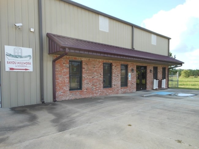
Property Record
47081 Conrad E Anderson St, Hammond, LA 70401


Property Detail
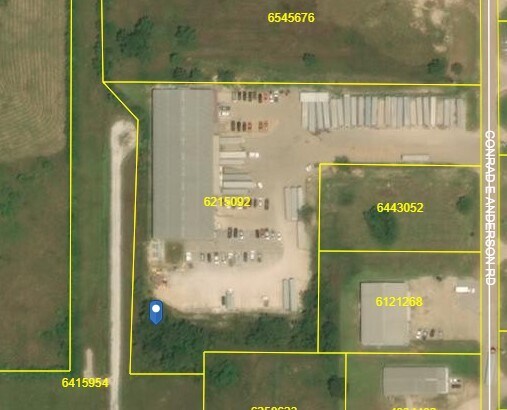
47081 Conrad E Anderson St
06215092
3.95A BEING TR A OF SURVEY IN SEC 8 T6SR8E B1074 P497 B1283 P346 B1287 P836 B1353 P456 B1415 P684-700 B1537 P472 B1577 P489 M
Commercialnec
Tangipahoa
B and X Area of moderate flood hazard, usually the area between the limits of the 100-year and 500-year floods.
Louisiana
2025
3.95 AC
2025
Louisiana South Area
954003
Other Market Areas
21,800 SF
Hammond, LA
NEARBY LISTINGS FOR SALE OR LEASE
-
-
View all Hammond listings for sale on LoopNet.com
DEMOGRAPHICS near 47081 Conrad E Anderson St
1 mile
3 mile
5 mile
2025 Total Population
873
11,973
41,634
2030 Population
915
12,510
43,344
Pop Growth 2025-2030
+ 4.81%
+ 4.49%
+ 4.11%
Average Age
40
38
37
2025 Total Households
351
4,858
16,139
HH Growth 2025-2030
+ 4.84%
+ 4.63%
+ 4.36%
Median Household Inc
$60,462
$54,890
$51,815
Avg Household Size
2.40
2.40
2.40
2025 Avg HH Vehicles
2.00
2.00
2.00
Median Home Value
$344,285
$257,583
$231,357
Median Year Built
1997
1997
1992
Nearby Places
Map Layers
Map Styles
 Street
 Aerial
Layers
 Traffic
 Biking
Places
Listings with unknown addresses are not visible on the map
- Restaurants
- Banks
- Shops
- Fitness
- Groceries
PUBLIC TRANSPORTATION
COMMUTER RAIL
Hammond Amtrak Station (City of New Orleans - Amtrak)
Drive
Walk
Distance
Hammond Amtrak Station (City of New Orleans - Amtrak)
9 min
4.4 mi
Freight Ports
Port of Greater Baton Rouge
Drive
Walk
Distance
Port of Greater Baton Rouge
69 min
53.5 mi
SALE & LEASE HISTORY
LISTING DATE
SALE/LEASE

Jan 17, 2021
For Sale
Nearby Properties
Address
Land Use
TOTAL SIZE
Lot Size
Zoning
Address
Land Use
TOTAL SIZE
Lot Size
Zoning
309,554 SF
98.69 AC
Address
Land Use
TOTAL SIZE
Lot Size
Zoning
666,424 SF
82.56 AC
Address
Land Use
TOTAL SIZE
Lot Size
Zoning
624,811 SF
41.75 AC
Address
Land Use
TOTAL SIZE
Lot Size
Zoning
52,074 SF
7.40 AC
Address
Land Use
TOTAL SIZE
Lot Size
Zoning
201,555 SF
11.17 AC
Address
Land Use
TOTAL SIZE
Lot Size
Zoning
165,402 SF
28.50 AC
Address
Land Use
TOTAL SIZE
Lot Size
Zoning
353.46 AC
Address
Land Use
TOTAL SIZE
Lot Size
Zoning
100,000 SF
6.32 AC
Address
Land Use
TOTAL SIZE
Lot Size
Zoning
62,962 SF
10.36 AC
Address
Land Use
TOTAL SIZE
Lot Size
Zoning
23,160 SF
6.16 AC
Address
Land Use
TOTAL SIZE
Lot Size
Zoning
31,136 SF
3.30 AC
Address
Land Use
TOTAL SIZE
Lot Size
Zoning
52,200 SF
14.24 AC
Address
Land Use
TOTAL SIZE
Lot Size
Zoning
26,000 SF
2.90 AC
Address
Land Use
TOTAL SIZE
Lot Size
Zoning
58,960 SF
8.88 AC
Address
Land Use
TOTAL SIZE
Lot Size
Zoning
68,000 SF
6.67 AC
Address
Land Use
TOTAL SIZE
Lot Size
Zoning
60,000 SF
11.76 AC
Address
Land Use
TOTAL SIZE
Lot Size
Zoning
5,700 SF
2.50 AC
Address
Land Use
TOTAL SIZE
Lot Size
Zoning
30,012 SF
2.51 AC
Address
Land Use
TOTAL SIZE
Lot Size
Zoning
38,679 SF
0.72 AC
Address
Land Use
TOTAL SIZE
Lot Size
Zoning
32,824 SF
3.47 AC
Address
Land Use
TOTAL SIZE
Lot Size
Zoning
56.15 AC
Address
Land Use
TOTAL SIZE
Lot Size
Zoning
15,060 SF
2.97 AC
Address
Land Use
TOTAL SIZE
Lot Size
Zoning
12,000 SF
1 AC
Address
Land Use
TOTAL SIZE
Lot Size
Zoning
20.03 AC
Address
Land Use
TOTAL SIZE
Lot Size
Zoning
31,250 SF
6.99 AC
Address
Land Use
TOTAL SIZE
Lot Size
Zoning
12,960 SF
31.95 AC
Address
Land Use
TOTAL SIZE
Lot Size
Zoning
176.32 AC
Address
Land Use
TOTAL SIZE
Lot Size
Zoning
12,000 SF
1 AC
Address
Land Use
TOTAL SIZE
Lot Size
Zoning
43,757 SF
4.24 AC
The World's #1 Commercial Real Estate Marketplace
Connect with us
© 2026 CoStar Group
The information above has been obtained from sources believed reliable. While we do not doubt its accuracy we have not verified it and make no guarantee, warranty or representation about it. It is your responsibility to independently confirm its accuracy and completeness. Any projections, opinions, assumptions, or estimates used are for example only and do not represent the current or future performance of the property. The value of this transaction to you depends on tax and other factors which should be evaluated by your tax, financial, and legal advisors. You and your advisors should conduct a careful, independent investigation of the property to determine to your satisfaction the suitability of the property for your needs.