Property Record
4709 Lawndale Dr, Greensboro, NC 27455

NEARBY LISTINGS FOR SALE OR LEASE
Property Detail
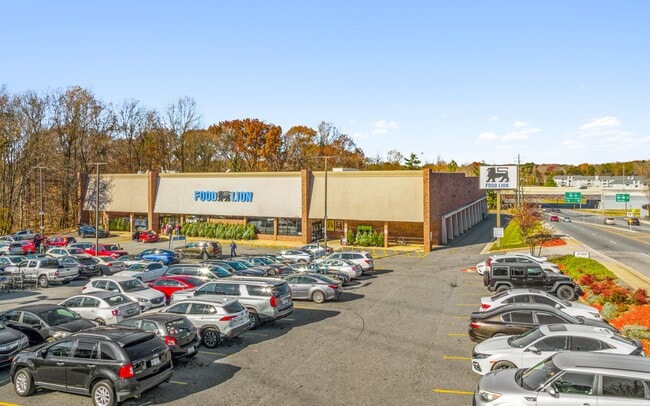
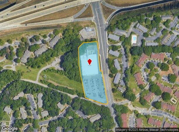
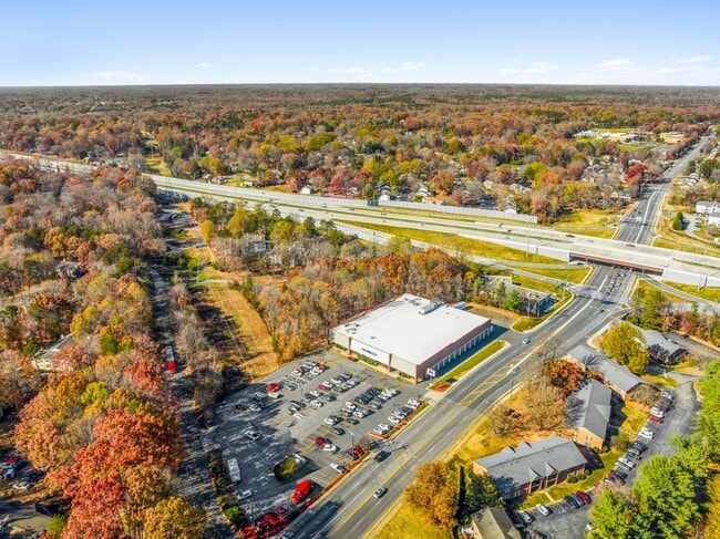
4709 Lawndale Dr
Greensboro-High Point, NC
Lawndale Square Shopping Cente
0088766
LAWNDALE SQUARE LO:1
Commercialnec
Guilford
X
North Carolina
3710785700J
1
2024
3.25 AC
2025
NW Guilford County
015705
Greensboro/Winston-Salem
37,340 SF
DEMOGRAPHICS near 4709 Lawndale Dr
1 Mile
3 Mile
5 Mile
2024 Total Population
8,325
55,803
136,640
2029 Population
8,202
55,319
135,824
Pop Growth 2024-2029
(1.48%)
(0.87%)
(0.60%)
Average Age
43
42
41
2024 Total Households
4,084
25,302
58,245
HH Growth 2024-2029
(1.54%)
(0.89%)
(0.60%)
Median Household Inc
$69,105
$76,389
$71,236
Avg Household Size
2.00
2.20
2.20
2024 Avg HH Vehicles
2.00
2.00
2.00
Median Home Value
$204,281
$274,062
$265,614
Median Year Built
1987
1987
1983
Nearby Places
Map Layers
Map Styles
 Street
 Aerial
- Restaurants
- Banks
- Shops
- Fitness
- Groceries
PUBLIC TRANSPORTATION
COMMUTER RAIL
Greensboro Station (Piedmont - North Carolina by Train (NC Train))
DRIVE
WALK
Distance
Greensboro Station (Piedmont - North Carolina by Train (NC Train))
12 min
6.0 mi
AIRPORT
Piedmont Triad International
DRIVE
WALK
Distance
Piedmont Triad International
17 min
8.9 mi
Freight Ports
Virginia Port Authority - Richmond
DRIVE
WALK
Distance
Virginia Port Authority - Richmond
234 min
203.7 mi
SALE & LEASE HISTORY
LISTING DATE
SALE/LEASE

Dec 15, 2023
For Sale
Nearby Properties
Address
Land Use
TOTAL SIZE
Lot Size
Zoning
Address
Land Use
TOTAL SIZE
Lot Size
Zoning
440,925 SF
72.55 AC
O
Address
Land Use
TOTAL SIZE
Lot Size
Zoning
472,566 SF
46.77 AC
RM-12
Address
Land Use
TOTAL SIZE
Lot Size
Zoning
106,706 SF
343.57 AC
PI
Address
Land Use
TOTAL SIZE
Lot Size
Zoning
309,598 SF
28.10 AC
RM-18
Address
Land Use
TOTAL SIZE
Lot Size
Zoning
317,844 SF
17.10 AC
PUD
Address
Land Use
TOTAL SIZE
Lot Size
Zoning
400,821 SF
30.06 AC
PUD
Address
Land Use
TOTAL SIZE
Lot Size
Zoning
227,063 SF
6.65 AC
C-H
Address
Land Use
TOTAL SIZE
Lot Size
Zoning
82,067 SF
9.41 AC
CU-SC
Address
Land Use
TOTAL SIZE
Lot Size
Zoning
223,891 SF
10.53 AC
PUD
Address
Land Use
TOTAL SIZE
Lot Size
Zoning
281,337 SF
20.64 AC
PUD
Address
Land Use
TOTAL SIZE
Lot Size
Zoning
466,399 SF
22.07 AC
RM-18
Address
Land Use
TOTAL SIZE
Lot Size
Zoning
222,661 SF
51.39 AC
R-3
Address
Land Use
TOTAL SIZE
Lot Size
Zoning
249,702 SF
15.39 AC
PUD
Address
Land Use
TOTAL SIZE
Lot Size
Zoning
263,148 SF
32.18 AC
RM-8
Address
Land Use
TOTAL SIZE
Lot Size
Zoning
204,438 SF
12.06 AC
RM-18
Address
Land Use
TOTAL SIZE
Lot Size
Zoning
252,109 SF
8.83 AC
PUD
Address
Land Use
TOTAL SIZE
Lot Size
Zoning
69,744 SF
100.01 AC
CD-O
Address
Land Use
TOTAL SIZE
Lot Size
Zoning
171,358 SF
11.91 AC
PUD
Address
Land Use
TOTAL SIZE
Lot Size
Zoning
223,272 SF
9.91 AC
RM-26
Address
Land Use
TOTAL SIZE
Lot Size
Zoning
302,048 SF
24.45 AC
RM-12
Address
Land Use
TOTAL SIZE
Lot Size
Zoning
138,773 SF
13.90 AC
C-H
Address
Land Use
TOTAL SIZE
Lot Size
Zoning
206,820 SF
14.59 AC
C-H
Address
Land Use
TOTAL SIZE
Lot Size
Zoning
209,515 SF
30.04 AC
RM-8
Address
Land Use
TOTAL SIZE
Lot Size
Zoning
137,800 SF
11.64 AC
RM-12
Address
Land Use
TOTAL SIZE
Lot Size
Zoning
231,049 SF
30.76 AC
RM-8
Address
Land Use
TOTAL SIZE
Lot Size
Zoning
194,064 SF
22.83 AC
RM-12
Address
Land Use
TOTAL SIZE
Lot Size
Zoning
316,644 SF
22.31 AC
RM-12
Address
Land Use
TOTAL SIZE
Lot Size
Zoning
141,750 SF
38.97 AC
PI
Address
Land Use
TOTAL SIZE
Lot Size
Zoning
175,238 SF
21.85 AC
C-H
Address
Land Use
TOTAL SIZE
Lot Size
Zoning
259,434 SF
23.69 AC
RM-12
The World's #1 Commercial Real Estate Marketplace
Connect with us
© 2025 CoStar Group
The information above has been obtained from sources believed reliable. While we do not doubt its accuracy we have not verified it and make no guarantee, warranty or representation about it. It is your responsibility to independently confirm its accuracy and completeness. Any projections, opinions, assumptions, or estimates used are for example only and do not represent the current or future performance of the property. The value of this transaction to you depends on tax and other factors which should be evaluated by your tax, financial, and legal advisors. You and your advisors should conduct a careful, independent investigation of the property to determine to your satisfaction the suitability of the property for your needs.